Property Record
2143 Main St, Athol, MA 01331
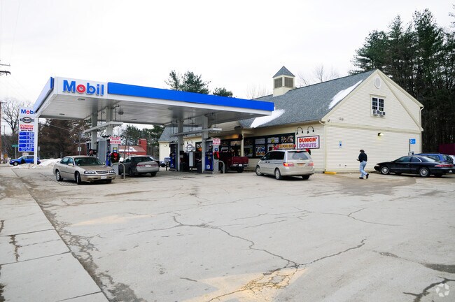

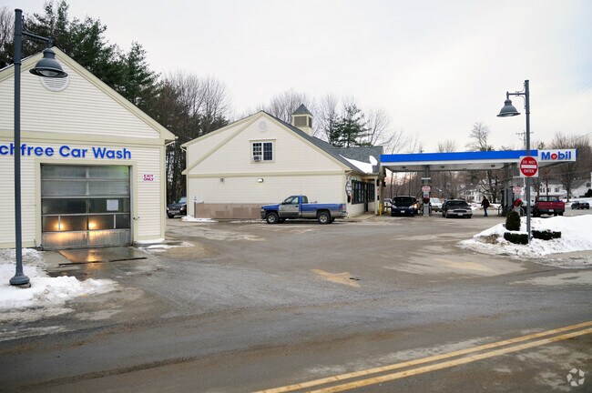
Property Detail
2143 Main St
Worcester, MA
Worcester
ATHO-000036-000105
Massachusetts
Commercialnec
0.83 AC
2025
Outlying Worcester
2025
Boston
703300
NEARBY LISTINGS FOR SALE OR LEASE
DEMOGRAPHICS near 2143 Main St
1 mile
3 mile
5 mile
2025 Total Population
3,210
12,322
19,046
2030 Population
3,373
12,775
19,678
Pop Growth 2025-2030
+ 5.08%
+ 3.68%
+ 3.32%
Average Age
43
43
44
2025 Total Households
1,313
5,032
7,868
HH Growth 2025-2030
+ 5.18%
+ 3.80%
+ 3.39%
Median Household Inc
$49,999
$67,861
$68,102
Avg Household Size
2.40
2.40
2.40
2025 Avg HH Vehicles
1.00
2.00
2.00
Median Home Value
$293,378
$289,510
$292,619
Median Year Built
1958
1954
1963
Nearby Places
Map Layers
Map Styles
 Street
 Aerial
Transit
 Traffic
 Biking
Places
Listings with unknown addresses are not visible on the map
- Restaurants
- Banks
- Shops
- Fitness
- Groceries
PUBLIC TRANSPORTATION
AIRPORT
Worcester Regional
Drive
Walk
Distance
Worcester Regional
60 min
33.5 mi
Nearby Properties
Address
Land Use
TOTAL SIZE
Lot Size
Zoning
Address
Land Use
TOTAL SIZE
Lot Size
Zoning
66,835 SF
12.39 AC
Address
Land Use
TOTAL SIZE
Lot Size
Zoning
76,943 SF
71.01 AC
Address
Land Use
TOTAL SIZE
Lot Size
Zoning
112,054 SF
10.48 AC
Address
Land Use
TOTAL SIZE
Lot Size
Zoning
22 AC
Address
Land Use
TOTAL SIZE
Lot Size
Zoning
66,766 SF
11 AC
Address
Land Use
TOTAL SIZE
Lot Size
Zoning
3.50 AC
Address
Land Use
TOTAL SIZE
Lot Size
Zoning
130,539 SF
Address
Land Use
TOTAL SIZE
Lot Size
Zoning
Address
Land Use
TOTAL SIZE
Lot Size
Zoning
49,820 SF
0.75 AC
Address
Land Use
TOTAL SIZE
Lot Size
Zoning
27,129 SF
3 AC
Address
Land Use
TOTAL SIZE
Lot Size
Zoning
43,043 SF
7.41 AC
A
Address
Land Use
TOTAL SIZE
Lot Size
Zoning
10.61 AC
Address
Land Use
TOTAL SIZE
Lot Size
Zoning
25,156 SF
4.80 AC
Address
Land Use
TOTAL SIZE
Lot Size
Zoning
30,327 SF
0.56 AC
Address
Land Use
TOTAL SIZE
Lot Size
Zoning
7.05 AC
Address
Land Use
TOTAL SIZE
Lot Size
Zoning
20,065 SF
Address
Land Use
TOTAL SIZE
Lot Size
Zoning
29,090 SF
0.57 AC
Address
Land Use
TOTAL SIZE
Lot Size
Zoning
3 AC
A
Address
Land Use
TOTAL SIZE
Lot Size
Zoning
237.06 AC
Address
Land Use
TOTAL SIZE
Lot Size
Zoning
10,204 SF
1.60 AC
Address
Land Use
TOTAL SIZE
Lot Size
Zoning
1,080.01 AC
Address
Land Use
TOTAL SIZE
Lot Size
Zoning
25,840 SF
5.99 AC
Address
Land Use
TOTAL SIZE
Lot Size
Zoning
61,096 SF
2.16 AC
Address
Land Use
TOTAL SIZE
Lot Size
Zoning
3.50 AC
Address
Land Use
TOTAL SIZE
Lot Size
Zoning
14,474 SF
1.03 AC
Address
Land Use
TOTAL SIZE
Lot Size
Zoning
2.10 AC
Address
Land Use
TOTAL SIZE
Lot Size
Zoning
14,723 SF
0.16 AC
Address
Land Use
TOTAL SIZE
Lot Size
Zoning
2.80 AC
Address
Land Use
TOTAL SIZE
Lot Size
Zoning
9,192 SF
0.82 AC
Address
Land Use
TOTAL SIZE
Lot Size
Zoning
32,286 SF
0.24 AC
The World's #1 Commercial Real Estate Marketplace
Connect with us
© 2026 CoStar Group
The information above has been obtained from sources believed reliable. While we do not doubt its accuracy we have not verified it and make no guarantee, warranty or representation about it. It is your responsibility to independently confirm its accuracy and completeness. Any projections, opinions, assumptions, or estimates used are for example only and do not represent the current or future performance of the property. The value of this transaction to you depends on tax and other factors which should be evaluated by your tax, financial, and legal advisors. You and your advisors should conduct a careful, independent investigation of the property to determine to your satisfaction the suitability of the property for your needs.