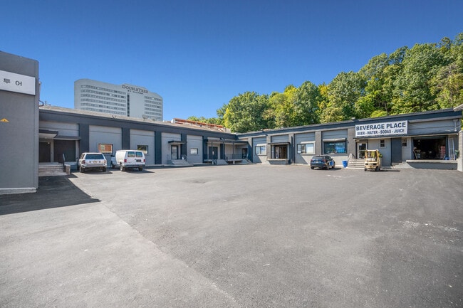
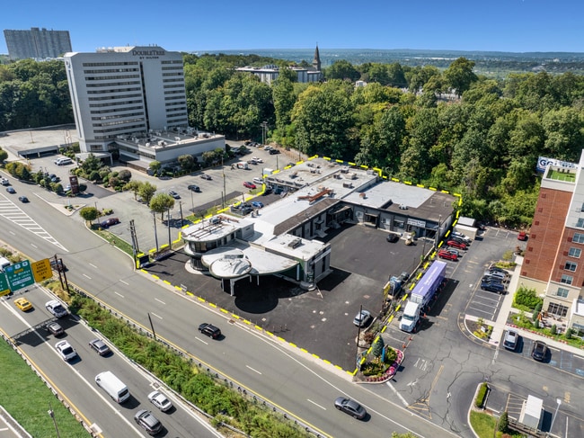
Property Record
2143 State Rt 4, Fort Lee, NJ 07024

Current Lease Availabilities
NEARBY LISTINGS FOR SALE OR LEASE
Property Detail
2143 State Rt 4
19-05452-0000-00001
2.210 AC
Commercialnec
Bergen
X
New Jersey
34003C0276H
1
2024
2.21 AC
2025
Englewood/Edgewater
019103
Northern New Jersey
39,630 SF
New York-Jersey City-White Plains, NY-NJ
DEMOGRAPHICS near 2143 State Rt 4
1 Mile
3 Mile
5 Mile
2024 Total Population
38,885
403,609
1,659,939
2029 Population
39,294
386,442
1,568,708
Pop Growth 2024-2029
+ 1.05%
(4.25%)
(5.50%)
Average Age
43
42
40
2024 Total Households
16,958
157,254
628,701
HH Growth 2024-2029
+ 1.26%
(4.25%)
(5.89%)
Median Household Inc
$90,944
$67,389
$52,637
Avg Household Size
2.20
2.50
2.50
2024 Avg HH Vehicles
1.00
1.00
1.00
Median Home Value
$447,741
$494,310
$518,111
Median Year Built
1969
1949
1952
Nearby Places
Map Layers
Map Styles
 Street
 Aerial
- Restaurants
- Banks
- Shops
- Fitness
- Groceries
PUBLIC TRANSPORTATION
COMMUTER RAIL
DRIVE
WALK
Distance
7 min
4.0 mi
University Heights Station (Hudson Line - Metro-North Commuter Railroad Company (Metro-North))
DRIVE
WALK
Distance
University Heights Station (Hudson Line - Metro-North Commuter Railroad Company (Metro-North))
9 min
4.7 mi
AIRPORT
LaGuardia
DRIVE
WALK
Distance
LaGuardia
22 min
12.0 mi
Newark Liberty International
DRIVE
WALK
Distance
Newark Liberty International
22 min
18.8 mi
John F Kennedy International
DRIVE
WALK
Distance
John F Kennedy International
33 min
23.1 mi
Freight Ports
NY - Red Hook Container Terminal
DRIVE
WALK
Distance
NY - Red Hook Container Terminal
34 min
17.5 mi
Nearby Properties
Address
Land Use
TOTAL SIZE
Lot Size
Zoning
Address
Land Use
TOTAL SIZE
Lot Size
Zoning
3,693,539 SF
8.37 AC
R8
Address
Land Use
TOTAL SIZE
Lot Size
Zoning
26.93 AC
R8
Address
Land Use
TOTAL SIZE
Lot Size
Zoning
24.08 AC
B2-A
Address
Land Use
TOTAL SIZE
Lot Size
Zoning
4.87 AC
R11
Address
Land Use
TOTAL SIZE
Lot Size
Zoning
1,651,267 SF
1.23 AC
R8
Address
Land Use
TOTAL SIZE
Lot Size
Zoning
7.64 AC
Address
Land Use
TOTAL SIZE
Lot Size
Zoning
Address
Land Use
TOTAL SIZE
Lot Size
Zoning
72 AC
P1
Address
Land Use
TOTAL SIZE
Lot Size
Zoning
2.61 AC
D5
Address
Land Use
TOTAL SIZE
Lot Size
Zoning
20.07 AC
H
Address
Land Use
TOTAL SIZE
Lot Size
Zoning
891,040 SF
5.63 AC
R8
Address
Land Use
TOTAL SIZE
Lot Size
Zoning
0.36 AC
R8
Address
Land Use
TOTAL SIZE
Lot Size
Zoning
23.12 AC
PARK
Address
Land Use
TOTAL SIZE
Lot Size
Zoning
74,550 SF
11.28 AC
OI
Address
Land Use
TOTAL SIZE
Lot Size
Zoning
3.75 AC
Address
Land Use
TOTAL SIZE
Lot Size
Zoning
42.68 AC
P1
Address
Land Use
TOTAL SIZE
Lot Size
Zoning
13.09 AC
C3
Address
Land Use
TOTAL SIZE
Lot Size
Zoning
2 AC
R11
Address
Land Use
TOTAL SIZE
Lot Size
Zoning
100,151 SF
22.13 AC
B2
Address
Land Use
TOTAL SIZE
Lot Size
Zoning
2.55 AC
D5
Address
Land Use
TOTAL SIZE
Lot Size
Zoning
807,327 SF
0.60 AC
R8
Address
Land Use
TOTAL SIZE
Lot Size
Zoning
39 AC
P1
Address
Land Use
TOTAL SIZE
Lot Size
Zoning
5.87 AC
R10
Address
Land Use
TOTAL SIZE
Lot Size
Zoning
2,531,670 SF
17.15 AC
R7-2
Address
Land Use
TOTAL SIZE
Lot Size
Zoning
Address
Land Use
TOTAL SIZE
Lot Size
Zoning
4.89 AC
R10
Address
Land Use
TOTAL SIZE
Lot Size
Zoning
317,485 SF
1.57 AC
R8
Address
Land Use
TOTAL SIZE
Lot Size
Zoning
43.65 AC
PARK
Address
Land Use
TOTAL SIZE
Lot Size
Zoning
26.11 AC
R1
Address
Land Use
TOTAL SIZE
Lot Size
Zoning
1.68 AC
R11
The World's #1 Commercial Real Estate Marketplace
Connect with us
© 2025 CoStar Group
The information above has been obtained from sources believed reliable. While we do not doubt its accuracy we have not verified it and make no guarantee, warranty or representation about it. It is your responsibility to independently confirm its accuracy and completeness. Any projections, opinions, assumptions, or estimates used are for example only and do not represent the current or future performance of the property. The value of this transaction to you depends on tax and other factors which should be evaluated by your tax, financial, and legal advisors. You and your advisors should conduct a careful, independent investigation of the property to determine to your satisfaction the suitability of the property for your needs.