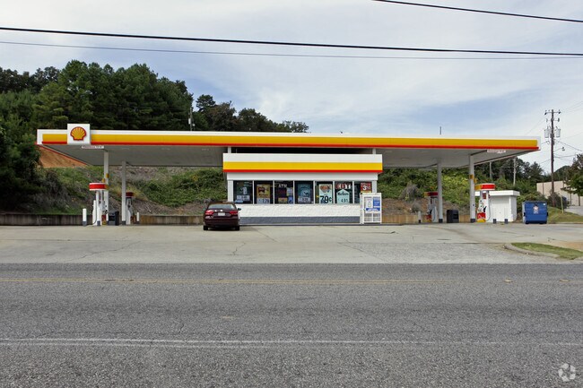
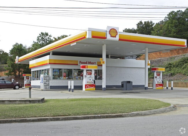
Property Record
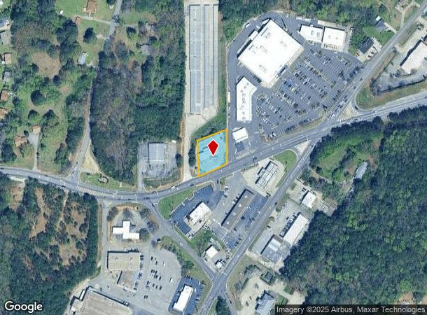
2143 Sweeney Hollow Rd, Birmingham, AL 35215

NEARBY LISTINGS FOR SALE OR LEASE
Property Detail
2143 Sweeney Hollow Rd
12-00-09-3-000-001.001
COM NE COR OF NE 1/4 OF SW 1/4 SEC 9 TP 16 R 1W TH S 616.4 FT TO POB TH CONT S 150 FT TH SWLY 150 FT TH N 150 FT TH NELY 150 FT TO POB SECT 09 TWSP 16S RA NGE1W
Storebuilding
Jefferson
X
Alabama
01073C0244J
0.52 AC
2023
Center Point
2024
Birmingham
011803
Birmingham-Hoover, AL
1,500 SF
DEMOGRAPHICS near 2143 Sweeney Hollow Rd
1 Mile
3 Mile
5 Mile
2024 Total Population
7,297
44,817
87,276
2029 Population
7,087
43,716
85,195
Pop Growth 2024-2029
(2.88%)
(2.46%)
(2.38%)
Average Age
37
37
38
2024 Total Households
2,758
16,786
32,667
HH Growth 2024-2029
(2.97%)
(2.50%)
(2.45%)
Median Household Inc
$54,358
$53,655
$57,229
Avg Household Size
2.60
2.60
2.60
2024 Avg HH Vehicles
2.00
2.00
2.00
Median Home Value
$147,653
$160,460
$167,998
Median Year Built
1987
1980
1979
Nearby Places
Map Layers
Map Styles
 Street
 Aerial
- Restaurants
- Banks
- Shops
- Fitness
- Groceries
PUBLIC TRANSPORTATION
AIRPORT
Birmingham-Shuttlesworth International
DRIVE
WALK
Distance
Birmingham-Shuttlesworth International
20 min
12.4 mi
Nearby Properties
Address
Land Use
TOTAL SIZE
Lot Size
Zoning
Address
Land Use
TOTAL SIZE
Lot Size
Zoning
204,463 SF
32.90 AC
PUD
Address
Land Use
TOTAL SIZE
Lot Size
Zoning
204,269 SF
17.94 AC
PUD
Address
Land Use
TOTAL SIZE
Lot Size
Zoning
207,383 SF
17 AC
CR5
Address
Land Use
TOTAL SIZE
Lot Size
Zoning
134,442 SF
26 AC
PUD
Address
Land Use
TOTAL SIZE
Lot Size
Zoning
192,596 SF
13.79 AC
CR5
Address
Land Use
TOTAL SIZE
Lot Size
Zoning
125,252 SF
8.07 AC
R4
Address
Land Use
TOTAL SIZE
Lot Size
Zoning
74,218 SF
4.50 AC
C2
Address
Land Use
TOTAL SIZE
Lot Size
Zoning
89,761 SF
11 AC
PUD
Address
Land Use
TOTAL SIZE
Lot Size
Zoning
116,732 SF
4.06 AC
R-4
Address
Land Use
TOTAL SIZE
Lot Size
Zoning
87,142 SF
10.80 AC
C-2
Address
Land Use
TOTAL SIZE
Lot Size
Zoning
43,451 SF
5.22 AC
INST
Address
Land Use
TOTAL SIZE
Lot Size
Zoning
109,878 SF
10 AC
C1
Address
Land Use
TOTAL SIZE
Lot Size
Zoning
74,159 SF
2.50 AC
INST
Address
Land Use
TOTAL SIZE
Lot Size
Zoning
43,298 SF
5.59 AC
INST
Address
Land Use
TOTAL SIZE
Lot Size
Zoning
4.21 AC
C2
Address
Land Use
TOTAL SIZE
Lot Size
Zoning
58,296 SF
6.25 AC
PUD
Address
Land Use
TOTAL SIZE
Lot Size
Zoning
56,360 SF
2.80 AC
INST
Address
Land Use
TOTAL SIZE
Lot Size
Zoning
39,251 SF
5.20 AC
C1
Address
Land Use
TOTAL SIZE
Lot Size
Zoning
69,066 SF
7.30 AC
C1
Address
Land Use
TOTAL SIZE
Lot Size
Zoning
25,408 SF
3.30 AC
C2
Address
Land Use
TOTAL SIZE
Lot Size
Zoning
20,036 SF
1.25 AC
PUD
Address
Land Use
TOTAL SIZE
Lot Size
Zoning
118,041 SF
5.10 AC
C1
Address
Land Use
TOTAL SIZE
Lot Size
Zoning
74,190 SF
8.80 AC
C2
Address
Land Use
TOTAL SIZE
Lot Size
Zoning
42,000 SF
5.10 AC
C1
Address
Land Use
TOTAL SIZE
Lot Size
Zoning
24,461 SF
1.35 AC
C1&C
Address
Land Use
TOTAL SIZE
Lot Size
Zoning
26,773 SF
22 AC
U1
Address
Land Use
TOTAL SIZE
Lot Size
Zoning
74,194 SF
3.80 AC
R4
Address
Land Use
TOTAL SIZE
Lot Size
Zoning
5,324 SF
9.80 AC
A1
Address
Land Use
TOTAL SIZE
Lot Size
Zoning
24,956 SF
1.30 AC
C2
Address
Land Use
TOTAL SIZE
Lot Size
Zoning
80,752 SF
7.86 AC
R4
The World's #1 Commercial Real Estate Marketplace
Connect with us
© 2025 CoStar Group
The information above has been obtained from sources believed reliable. While we do not doubt its accuracy we have not verified it and make no guarantee, warranty or representation about it. It is your responsibility to independently confirm its accuracy and completeness. Any projections, opinions, assumptions, or estimates used are for example only and do not represent the current or future performance of the property. The value of this transaction to you depends on tax and other factors which should be evaluated by your tax, financial, and legal advisors. You and your advisors should conduct a careful, independent investigation of the property to determine to your satisfaction the suitability of the property for your needs.