Property Record
21435 S Vanzant Rd, Springdale, AR 72764
NEARBY LISTINGS FOR SALE OR LEASE
-
-
View all Springdale listings for sale on LoopNet.com
Property Detail
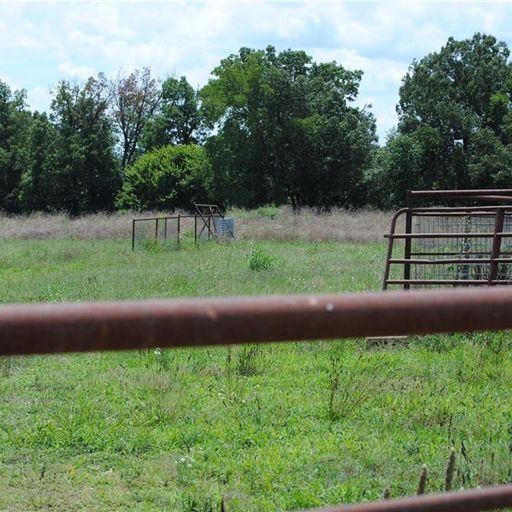
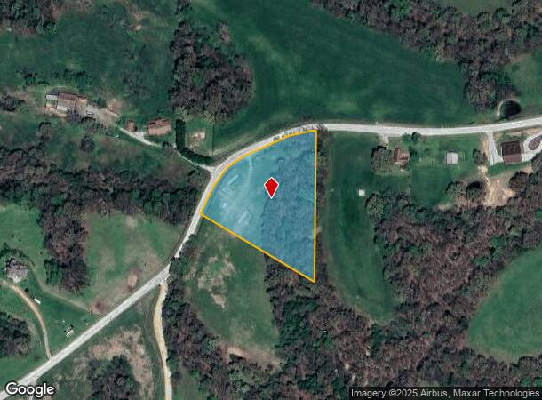
21435 S Vanzant Rd
Fayetteville-Springdale-Rogers, AR-MO
10-17-28
001-13831-002
PT NE SW & PT SE SW 3.10 AC FURTHER DESCRIBED FROM 2024-19814 AS: PART OF THE EAST HALF OF THE SOUTHWEST QUARTER OF SECTION 1
Residentialacreage
Washington
X
Arkansas
05143C0125G
3.10 AC
2025
Outlying Washington Cnty
2025
Fayetteville/Springdale/Rogers
010109
DEMOGRAPHICS near 21435 S Vanzant Rd
1 Mile
3 Mile
5 Mile
2024 Total Population
146
1,441
6,508
2029 Population
161
1,590
7,178
Pop Growth 2024-2029
+ 10.27%
+ 10.34%
+ 10.30%
Average Age
43
43
42
2024 Total Households
56
553
2,472
HH Growth 2024-2029
+ 10.71%
+ 10.67%
+ 10.52%
Median Household Inc
$76,250
$79,301
$79,890
Avg Household Size
2.60
2.60
2.60
2024 Avg HH Vehicles
2.00
2.00
2.00
Median Home Value
$241,304
$254,189
$261,009
Median Year Built
1988
1990
1993
Nearby Places
Map Layers
Map Styles
 Street
 Aerial
- Restaurants
- Banks
- Shops
- Fitness
- Groceries
PUBLIC TRANSPORTATION
AIRPORT
Northwest Arkansas Ntl
DRIVE
WALK
Distance
Northwest Arkansas Ntl
58 min
30.3 mi
Freight Ports
Tulsa Port of Inola
DRIVE
WALK
Distance
Tulsa Port of Inola
126 min
101.7 mi
SALE & LEASE HISTORY
LISTING DATE
SALE/LEASE

Jan 18, 2023
For Sale
Apr 18, 2023
For Sale
Nearby Properties
Address
Land Use
TOTAL SIZE
Lot Size
Zoning
Address
Land Use
TOTAL SIZE
Lot Size
Zoning
960 SF
48.97 AC
AA1
Address
Land Use
TOTAL SIZE
Lot Size
Zoning
6,198 SF
31.91 AC
AA1
Address
Land Use
TOTAL SIZE
Lot Size
Zoning
52,900 SF
7.84 AC
AA1
Address
Land Use
TOTAL SIZE
Lot Size
Zoning
38,756 SF
8 AC
AA1
Address
Land Use
TOTAL SIZE
Lot Size
Zoning
24,120 SF
5 AC
AA1
Address
Land Use
TOTAL SIZE
Lot Size
Zoning
23.55 AC
AA1
Address
Land Use
TOTAL SIZE
Lot Size
Zoning
12,000 SF
3.48 AC
Address
Land Use
TOTAL SIZE
Lot Size
Zoning
26,916 SF
8.84 AC
Address
Land Use
TOTAL SIZE
Lot Size
Zoning
9,146 SF
2.24 AC
Address
Land Use
TOTAL SIZE
Lot Size
Zoning
1,216 SF
5 AC
Address
Land Use
TOTAL SIZE
Lot Size
Zoning
3,840 SF
1.97 AC
AA1
Address
Land Use
TOTAL SIZE
Lot Size
Zoning
4,292 SF
13.17 AC
AA1
Address
Land Use
TOTAL SIZE
Lot Size
Zoning
638 SF
22 AC
AA1
Address
Land Use
TOTAL SIZE
Lot Size
Zoning
1,020 SF
2 AC
AA1
Address
Land Use
TOTAL SIZE
Lot Size
Zoning
4,130 SF
1.77 AC
AA1
Address
Land Use
TOTAL SIZE
Lot Size
Zoning
Address
Land Use
TOTAL SIZE
Lot Size
Zoning
3.05 AC
AA1
Address
Land Use
TOTAL SIZE
Lot Size
Zoning
3,280 SF
12.02 AC
AA1
Address
Land Use
TOTAL SIZE
Lot Size
Zoning
3,037 SF
1 AC
AA1
Address
Land Use
TOTAL SIZE
Lot Size
Zoning
Address
Land Use
TOTAL SIZE
Lot Size
Zoning
3,750 SF
1.51 AC
Address
Land Use
TOTAL SIZE
Lot Size
Zoning
2.57 AC
Address
Land Use
TOTAL SIZE
Lot Size
Zoning
12.07 AC
Address
Land Use
TOTAL SIZE
Lot Size
Zoning
10 AC
AA1
Address
Land Use
TOTAL SIZE
Lot Size
Zoning
0.86 AC
Address
Land Use
TOTAL SIZE
Lot Size
Zoning
38.12 AC
AA1
Address
Land Use
TOTAL SIZE
Lot Size
Zoning
672 SF
20.09 AC
AA1
Address
Land Use
TOTAL SIZE
Lot Size
Zoning
13.44 AC
AA1
Address
Land Use
TOTAL SIZE
Lot Size
Zoning
3,780 SF
6.70 AC
AA1
Address
Land Use
TOTAL SIZE
Lot Size
Zoning
1,216 SF
4.67 AC
AA1
The World's #1 Commercial Real Estate Marketplace
Connect with us
© 2026 CoStar Group
The information above has been obtained from sources believed reliable. While we do not doubt its accuracy we have not verified it and make no guarantee, warranty or representation about it. It is your responsibility to independently confirm its accuracy and completeness. Any projections, opinions, assumptions, or estimates used are for example only and do not represent the current or future performance of the property. The value of this transaction to you depends on tax and other factors which should be evaluated by your tax, financial, and legal advisors. You and your advisors should conduct a careful, independent investigation of the property to determine to your satisfaction the suitability of the property for your needs.