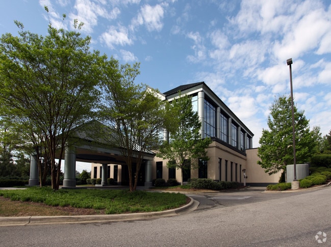
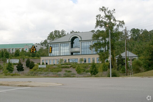
Property Record
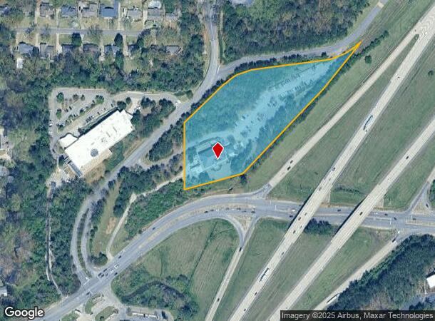
2145 Bonner Way, Birmingham, AL 35243
NEARBY LISTINGS FOR SALE OR LEASE
Property Detail
2145 Bonner Way
40-00-04-2-000-005.001
COM SW COR NW 1/4 NW 1/4 SEC 4 TP 19 R 2W TH E 183.1 FT TO POB TH NE 164.9 FT TH NELY 308 FT TH NE 178.5 FT TH SW 244.8 FT TH SWLY 540.6 FT TH SW 280 FT TH N 310 FT TH NE 260 FT TO POB SECT 04 TWSP 19S RANGE 2W
Medicalbuilding
Jefferson
X
Alabama
01117C0067F
5.30 AC
0
Hwy 280/Jefferson County
2024
Birmingham
012911
Birmingham-Hoover, AL
19,540 SF
DEMOGRAPHICS near 2145 Bonner Way
1 Mile
3 Mile
5 Mile
2024 Total Population
3,515
54,401
140,217
2029 Population
3,444
54,126
140,330
Pop Growth 2024-2029
(2.02%)
(0.51%)
+ 0.08%
Average Age
41
40
39
2024 Total Households
1,314
23,381
57,810
HH Growth 2024-2029
(2.44%)
(0.58%)
(0.01%)
Median Household Inc
$101,820
$83,013
$89,979
Avg Household Size
2.60
2.30
2.30
2024 Avg HH Vehicles
2.00
2.00
2.00
Median Home Value
$400,838
$364,743
$373,321
Median Year Built
1981
1984
1983
Nearby Places
Map Layers
Map Styles
 Street
 Aerial
- Restaurants
- Banks
- Shops
- Fitness
- Groceries
PUBLIC TRANSPORTATION
AIRPORT
Birmingham-Shuttlesworth International
DRIVE
WALK
Distance
Birmingham-Shuttlesworth International
25 min
14.9 mi
Nearby Properties
Address
Land Use
TOTAL SIZE
Lot Size
Zoning
Address
Land Use
TOTAL SIZE
Lot Size
Zoning
200,418 SF
6.50 AC
C1
Address
Land Use
TOTAL SIZE
Lot Size
Zoning
1,008,008 SF
73.91 AC
R4
Address
Land Use
TOTAL SIZE
Lot Size
Zoning
212,615 SF
19.66 AC
B-2
Address
Land Use
TOTAL SIZE
Lot Size
Zoning
140,853 SF
27 AC
B-2
Address
Land Use
TOTAL SIZE
Lot Size
Zoning
7,280 SF
35 AC
Address
Land Use
TOTAL SIZE
Lot Size
Zoning
347,636 SF
136.83 AC
Address
Land Use
TOTAL SIZE
Lot Size
Zoning
6 AC
C-1
Address
Land Use
TOTAL SIZE
Lot Size
Zoning
169,501 SF
18 AC
E-2
Address
Land Use
TOTAL SIZE
Lot Size
Zoning
136,498 SF
11 AC
C1
Address
Land Use
TOTAL SIZE
Lot Size
Zoning
30,967 SF
17.39 AC
Address
Land Use
TOTAL SIZE
Lot Size
Zoning
235,082 SF
26.10 AC
C1
Address
Land Use
TOTAL SIZE
Lot Size
Zoning
102,373 SF
12.33 AC
R1-E
Address
Land Use
TOTAL SIZE
Lot Size
Zoning
344,434 SF
15.52 AC
R4
Address
Land Use
TOTAL SIZE
Lot Size
Zoning
239,213 SF
17 AC
C1
Address
Land Use
TOTAL SIZE
Lot Size
Zoning
321,157 SF
33 AC
C
Address
Land Use
TOTAL SIZE
Lot Size
Zoning
59,454 SF
4.21 AC
C1
Address
Land Use
TOTAL SIZE
Lot Size
Zoning
365,402 SF
25 AC
R4
Address
Land Use
TOTAL SIZE
Lot Size
Zoning
11,492 SF
21.30 AC
Address
Land Use
TOTAL SIZE
Lot Size
Zoning
125,165 SF
8.07 AC
CP
Address
Land Use
TOTAL SIZE
Lot Size
Zoning
89,134 SF
6.50 AC
C-1
Address
Land Use
TOTAL SIZE
Lot Size
Zoning
294,855 SF
30 AC
R4
Address
Land Use
TOTAL SIZE
Lot Size
Zoning
5,506 SF
17.36 AC
Address
Land Use
TOTAL SIZE
Lot Size
Zoning
1,400 SF
21.35 AC
Address
Land Use
TOTAL SIZE
Lot Size
Zoning
121,872 SF
8.70 AC
PB
Address
Land Use
TOTAL SIZE
Lot Size
Zoning
170,850 SF
9.31 AC
INST
Address
Land Use
TOTAL SIZE
Lot Size
Zoning
252,432 SF
17.99 AC
R5
Address
Land Use
TOTAL SIZE
Lot Size
Zoning
219,277 SF
22.50 AC
R5
Address
Land Use
TOTAL SIZE
Lot Size
Zoning
83,792 SF
9.94 AC
Address
Land Use
TOTAL SIZE
Lot Size
Zoning
94,126 SF
10 AC
C-1
Address
Land Use
TOTAL SIZE
Lot Size
Zoning
83,476 SF
5.60 AC
C1
The World's #1 Commercial Real Estate Marketplace
Connect with us
© 2025 CoStar Group
The information above has been obtained from sources believed reliable. While we do not doubt its accuracy we have not verified it and make no guarantee, warranty or representation about it. It is your responsibility to independently confirm its accuracy and completeness. Any projections, opinions, assumptions, or estimates used are for example only and do not represent the current or future performance of the property. The value of this transaction to you depends on tax and other factors which should be evaluated by your tax, financial, and legal advisors. You and your advisors should conduct a careful, independent investigation of the property to determine to your satisfaction the suitability of the property for your needs.