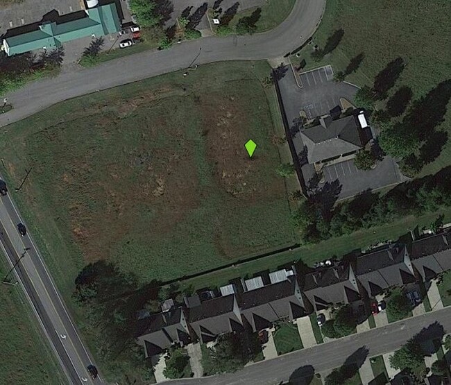
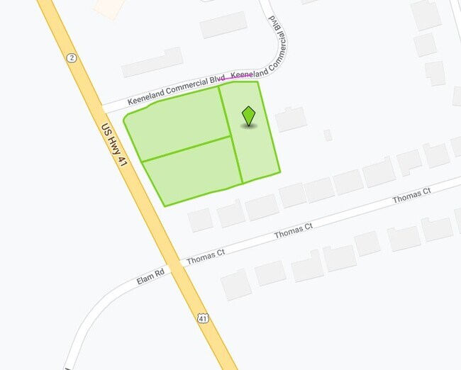
Property Record
2145 Manchester Pike, Murfreesboro, TN 37127
Property Detail
2145 Manchester Pike
Nashville-Davidson--Murfreesboro--Franklin, TN
LOT 12 KEENELAND COMMERCIAL CENTER RESUB PB 25 PG 25 107.67 X 238.22 IRR RESUB FOR LOTS 8 & 10-19
112H-B-009.00-000
RUTHERFORD
Commercialacreage
Tennessee
B and X Area of moderate flood hazard, usually the area between the limits of the 100-year and 500-year floods.
12
2025
0.72 AC
2025
Rutherford County
041202
Nashville
NEARBY LISTINGS FOR SALE OR LEASE
DEMOGRAPHICS near 2145 Manchester Pike
1 mile
3 mile
5 mile
2025 Total Population
4,049
52,288
119,252
2030 Population
4,383
56,455
128,767
Pop Growth 2025-2030
+ 8.25%
+ 7.97%
+ 7.98%
Average Age
40
35
36
2025 Total Households
1,486
19,672
46,870
HH Growth 2025-2030
+ 8.41%
+ 8.42%
+ 8.21%
Median Household Inc
$75,945
$62,477
$66,839
Avg Household Size
2.60
2.40
2.40
2025 Avg HH Vehicles
2.00
2.00
2.00
Median Home Value
$384,908
$378,148
$387,555
Median Year Built
1993
1994
1995
Nearby Places
Map Layers
Map Styles
 Street
 Aerial
Transit
 Traffic
 Biking
Places
Listings with unknown addresses are not visible on the map
- Restaurants
- Banks
- Shops
- Fitness
- Groceries
PUBLIC TRANSPORTATION
AIRPORT
Nashville International
Drive
Walk
Distance
Nashville International
39 min
31.1 mi
Nearby Properties
Address
Land Use
TOTAL SIZE
Lot Size
Zoning
Address
Land Use
TOTAL SIZE
Lot Size
Zoning
1,015,800 SF
83.85 AC
Address
Land Use
TOTAL SIZE
Lot Size
Zoning
520,119 SF
34.82 AC
Address
Land Use
TOTAL SIZE
Lot Size
Zoning
844,480 SF
49.10 AC
Address
Land Use
TOTAL SIZE
Lot Size
Zoning
166,604 SF
2.21 AC
Address
Land Use
TOTAL SIZE
Lot Size
Zoning
295,095 SF
80 AC
Address
Land Use
TOTAL SIZE
Lot Size
Zoning
10,760 SF
19.48 AC
Address
Land Use
TOTAL SIZE
Lot Size
Zoning
2,472 SF
44.34 AC
Address
Land Use
TOTAL SIZE
Lot Size
Zoning
120,225 SF
20.40 AC
Address
Land Use
TOTAL SIZE
Lot Size
Zoning
381,749 SF
74.59 AC
Address
Land Use
TOTAL SIZE
Lot Size
Zoning
172,096 SF
25 AC
Address
Land Use
TOTAL SIZE
Lot Size
Zoning
102,366 SF
7.90 AC
Address
Land Use
TOTAL SIZE
Lot Size
Zoning
4,842 SF
17.80 AC
Address
Land Use
TOTAL SIZE
Lot Size
Zoning
5,130 SF
17.07 AC
RM16
Address
Land Use
TOTAL SIZE
Lot Size
Zoning
4,409 SF
21.60 AC
RM16
Address
Land Use
TOTAL SIZE
Lot Size
Zoning
78,768 SF
1.50 AC
Address
Land Use
TOTAL SIZE
Lot Size
Zoning
3,104 SF
16.01 AC
RM16
Address
Land Use
TOTAL SIZE
Lot Size
Zoning
479,592 SF
56.83 AC
I
Address
Land Use
TOTAL SIZE
Lot Size
Zoning
120,638 SF
20.55 AC
Address
Land Use
TOTAL SIZE
Lot Size
Zoning
6,253 SF
38.80 AC
RM16
Address
Land Use
TOTAL SIZE
Lot Size
Zoning
57,146 SF
3.47 AC
Address
Land Use
TOTAL SIZE
Lot Size
Zoning
123,688 SF
15.27 AC
Address
Land Use
TOTAL SIZE
Lot Size
Zoning
379,080 SF
24.20 AC
Address
Land Use
TOTAL SIZE
Lot Size
Zoning
1,945 SF
16.22 AC
RM16
Address
Land Use
TOTAL SIZE
Lot Size
Zoning
110,449 SF
7.29 AC
Address
Land Use
TOTAL SIZE
Lot Size
Zoning
174,185 SF
25.23 AC
Address
Land Use
TOTAL SIZE
Lot Size
Zoning
152,768 SF
1.19 AC
Address
Land Use
TOTAL SIZE
Lot Size
Zoning
121,104 SF
24.92 AC
Address
Land Use
TOTAL SIZE
Lot Size
Zoning
3,147 SF
8.51 AC
Address
Land Use
TOTAL SIZE
Lot Size
Zoning
49,341 SF
0.23 AC
Address
Land Use
TOTAL SIZE
Lot Size
Zoning
6,788 SF
13.80 AC
RM12
The World's #1 Commercial Real Estate Marketplace
Connect with us
© 2026 CoStar Group
The information above has been obtained from sources believed reliable. While we do not doubt its accuracy we have not verified it and make no guarantee, warranty or representation about it. It is your responsibility to independently confirm its accuracy and completeness. Any projections, opinions, assumptions, or estimates used are for example only and do not represent the current or future performance of the property. The value of this transaction to you depends on tax and other factors which should be evaluated by your tax, financial, and legal advisors. You and your advisors should conduct a careful, independent investigation of the property to determine to your satisfaction the suitability of the property for your needs.