Property Record
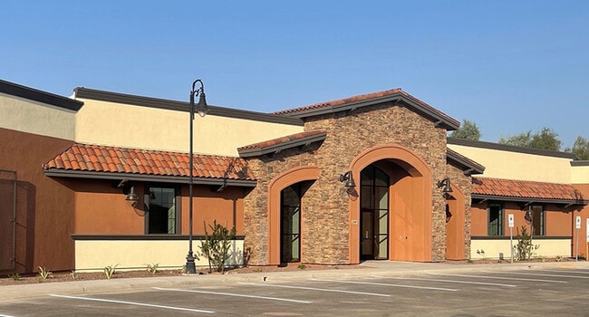
2145 W 28Th St, Yuma, AZ 85364

Property Detail
2145 W 28Th St
694-21-047
SUBDIVISION: TUSCANY MEDICAL & PROFESSIONAL PLAZA PHASE 2 LOT: 38 SECTION: 05 TOWNSHIP: 09S RANGE: 23W
Hospitalpublic
Yuma
B-2
Arizona
C and X Area of minimal flood hazard, usually depicted on FIRMs as above the 500-year flood level.
38
2025
0.60 AC
2026
Yuma & El Centro
000907
Other Market Areas
13,896 SF
Yuma, AZ
NEARBY LISTINGS FOR SALE OR LEASE
DEMOGRAPHICS near 2145 W 28Th St
1 mile
3 mile
5 mile
2025 Total Population
10,830
79,088
98,588
2030 Population
11,618
85,140
105,884
Pop Growth 2025-2030
+ 7.28%
+ 7.65%
+ 7.40%
Average Age
36
38
37
2025 Total Households
3,549
28,610
34,845
HH Growth 2025-2030
+ 8.09%
+ 8.78%
+ 8.43%
Median Household Inc
$67,898
$61,772
$59,229
Avg Household Size
2.90
2.70
2.70
2025 Avg HH Vehicles
2.00
2.00
2.00
Median Home Value
$252,718
$237,223
$230,672
Median Year Built
1989
1985
1985
Nearby Places
Map Layers
Map Styles
 Street
 Aerial
Layers
 Traffic
 Biking
Places
Listings with unknown addresses are not visible on the map
- Restaurants
- Banks
- Shops
- Fitness
- Groceries
PUBLIC TRANSPORTATION
COMMUTER RAIL
Drive
Walk
Distance
11 min
5.5 mi
AIRPORT
Yuma International
Drive
Walk
Distance
Yuma International
9 min
3.4 mi
Nearby Properties
Address
Land Use
TOTAL SIZE
Lot Size
Zoning
Address
Land Use
TOTAL SIZE
Lot Size
Zoning
383,999 SF
87.91 AC
R-1-6
Address
Land Use
TOTAL SIZE
Lot Size
Zoning
163,094 SF
27 AC
AG
Address
Land Use
TOTAL SIZE
Lot Size
Zoning
406,808 SF
28.05 AC
R-3
Address
Land Use
TOTAL SIZE
Lot Size
Zoning
206,107 SF
21.96 AC
B-2
Address
Land Use
TOTAL SIZE
Lot Size
Zoning
61,000 SF
36.50 AC
B-2
Address
Land Use
TOTAL SIZE
Lot Size
Zoning
79,891 SF
8.97 AC
R-1-6
Address
Land Use
TOTAL SIZE
Lot Size
Zoning
155,526 SF
52.75 AC
R-1-6
Address
Land Use
TOTAL SIZE
Lot Size
Zoning
212,439 SF
20.28 AC
B-1
Address
Land Use
TOTAL SIZE
Lot Size
Zoning
51,586 SF
6.71 AC
B-2
Address
Land Use
TOTAL SIZE
Lot Size
Zoning
264,412 SF
28.05 AC
LI
Address
Land Use
TOTAL SIZE
Lot Size
Zoning
95,263 SF
5.46 AC
B-2
Address
Land Use
TOTAL SIZE
Lot Size
Zoning
57,308 SF
12.32 AC
R-1-6
Address
Land Use
TOTAL SIZE
Lot Size
Zoning
50,918 SF
3.85 AC
TR
Address
Land Use
TOTAL SIZE
Lot Size
Zoning
68,961 SF
3.23 AC
B-2
Address
Land Use
TOTAL SIZE
Lot Size
Zoning
168,098 SF
8.77 AC
R-3
Address
Land Use
TOTAL SIZE
Lot Size
Zoning
48,251 SF
5.26 AC
B-2
Address
Land Use
TOTAL SIZE
Lot Size
Zoning
302,392 SF
16.80 AC
R-3
Address
Land Use
TOTAL SIZE
Lot Size
Zoning
165,296 SF
12.44 AC
R-3
Address
Land Use
TOTAL SIZE
Lot Size
Zoning
33,765 SF
2.81 AC
B-2
Address
Land Use
TOTAL SIZE
Lot Size
Zoning
90,280 SF
2.98 AC
B-2
Address
Land Use
TOTAL SIZE
Lot Size
Zoning
84,444 SF
17.21 AC
AG
Address
Land Use
TOTAL SIZE
Lot Size
Zoning
97,660 SF
8.81 AC
B-2
Address
Land Use
TOTAL SIZE
Lot Size
Zoning
91,382 SF
52.31 AC
HI
Address
Land Use
TOTAL SIZE
Lot Size
Zoning
56,885 SF
22.04 AC
R-1-6
Address
Land Use
TOTAL SIZE
Lot Size
Zoning
89,787 SF
35.18 AC
AG
Address
Land Use
TOTAL SIZE
Lot Size
Zoning
96,278 SF
9.71 AC
B-1
Address
Land Use
TOTAL SIZE
Lot Size
Zoning
148,326 SF
8.27 AC
R-3
Address
Land Use
TOTAL SIZE
Lot Size
Zoning
57,210 SF
7.19 AC
B-1
Address
Land Use
TOTAL SIZE
Lot Size
Zoning
55,729 SF
3.25 AC
B-2
The World's #1 Commercial Real Estate Marketplace
Connect with us
© 2026 CoStar Group
The information above has been obtained from sources believed reliable. While we do not doubt its accuracy we have not verified it and make no guarantee, warranty or representation about it. It is your responsibility to independently confirm its accuracy and completeness. Any projections, opinions, assumptions, or estimates used are for example only and do not represent the current or future performance of the property. The value of this transaction to you depends on tax and other factors which should be evaluated by your tax, financial, and legal advisors. You and your advisors should conduct a careful, independent investigation of the property to determine to your satisfaction the suitability of the property for your needs.