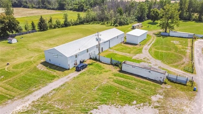
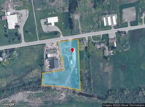
Property Record
2146 State Route 31, Port Byron, NY 13140

NEARBY LISTINGS FOR SALE OR LEASE
-
-
View all Port Byron listings for sale on LoopNet.com
Property Detail
2146 State Route 31
053889 82.00-1-29.112
Cayuga
Storesoffices
New York
X
29.112
36011C0236E
3.82 AC
2025
Syracuse Surrounding
2024
Other Market Areas
040300
Auburn, NY
5,600 SF
DEMOGRAPHICS near 2146 State Route 31
1 Mile
3 Mile
5 Mile
2024 Total Population
234
4,472
8,100
2029 Population
227
4,365
7,932
Pop Growth 2024-2029
(2.99%)
(2.39%)
(2.07%)
Average Age
43
44
44
2024 Total Households
91
1,798
3,244
HH Growth 2024-2029
(2.20%)
(2.56%)
(2.22%)
Median Household Inc
$51,250
$60,288
$67,784
Avg Household Size
2.40
2.40
2.40
2024 Avg HH Vehicles
2.00
2.00
2.00
Median Home Value
$128,333
$135,496
$144,449
Median Year Built
1948
1958
1964
Nearby Places
- Restaurants
- Banks
- Shops
- Fitness
- Groceries
PUBLIC TRANSPORTATION
AIRPORT
Syracuse Hancock International
DRIVE
WALK
Distance
Syracuse Hancock International
38 min
28.5 mi
Freight Ports
Albany, NY Port
DRIVE
WALK
Distance
Albany, NY Port
198 min
167.7 mi
SALE & LEASE HISTORY
LISTING DATE
SALE/LEASE

Sep 23, 2021
For Sale
Nearby Properties
Address
Land Use
TOTAL SIZE
Lot Size
Zoning
Address
Land Use
TOTAL SIZE
Lot Size
Zoning
40,000 SF
84.10 AC
AR
Address
Land Use
TOTAL SIZE
Lot Size
Zoning
135,792 SF
34.80 AC
R
Address
Land Use
TOTAL SIZE
Lot Size
Zoning
7,560 SF
12 AC
I
Address
Land Use
TOTAL SIZE
Lot Size
Zoning
45,878 SF
7.43 AC
R
Address
Land Use
TOTAL SIZE
Lot Size
Zoning
1,316 SF
1.86 AC
R
Address
Land Use
TOTAL SIZE
Lot Size
Zoning
45,996 SF
18.70 AC
R
Address
Land Use
TOTAL SIZE
Lot Size
Zoning
50,784 SF
8.90 AC
R
Address
Land Use
TOTAL SIZE
Lot Size
Zoning
1,581 SF
13.40 AC
I
Address
Land Use
TOTAL SIZE
Lot Size
Zoning
10,000 SF
1.13 AC
R-1
Address
Land Use
TOTAL SIZE
Lot Size
Zoning
5,432 SF
1.17 AC
C
Address
Land Use
TOTAL SIZE
Lot Size
Zoning
14,100 SF
0.53 AC
C
Address
Land Use
TOTAL SIZE
Lot Size
Zoning
9,750 SF
8 AC
I/RF
Address
Land Use
TOTAL SIZE
Lot Size
Zoning
3,056 SF
0.61 AC
C-1
Address
Land Use
TOTAL SIZE
Lot Size
Zoning
788 SF
20.28 AC
AR
Address
Land Use
TOTAL SIZE
Lot Size
Zoning
11,550 SF
0.80 AC
C
Address
Land Use
TOTAL SIZE
Lot Size
Zoning
17,900 SF
9.70 AC
I
Address
Land Use
TOTAL SIZE
Lot Size
Zoning
2,204 SF
22.50 AC
C
Address
Land Use
TOTAL SIZE
Lot Size
Zoning
8,824 SF
1.90 AC
CR
Address
Land Use
TOTAL SIZE
Lot Size
Zoning
4,248 SF
1 AC
R
Address
Land Use
TOTAL SIZE
Lot Size
Zoning
1,064 SF
6 AC
R-2
Address
Land Use
TOTAL SIZE
Lot Size
Zoning
40,000 SF
5.40 AC
R
Address
Land Use
TOTAL SIZE
Lot Size
Zoning
14,702 SF
1.79 AC
C
Address
Land Use
TOTAL SIZE
Lot Size
Zoning
12,756 SF
0.55 AC
R
Address
Land Use
TOTAL SIZE
Lot Size
Zoning
2,176 SF
1.20 AC
C
Address
Land Use
TOTAL SIZE
Lot Size
Zoning
2,737 SF
1.50 AC
C
Address
Land Use
TOTAL SIZE
Lot Size
Zoning
5,298 SF
4.80 AC
R-1
Address
Land Use
TOTAL SIZE
Lot Size
Zoning
13,018 SF
8.23 AC
C
Address
Land Use
TOTAL SIZE
Lot Size
Zoning
11,076 SF
1.90 AC
R
Address
Land Use
TOTAL SIZE
Lot Size
Zoning
2,072 SF
0.42 AC
C
Address
Land Use
TOTAL SIZE
Lot Size
Zoning
8,050 SF
0.80 AC
C-1
The World's #1 Commercial Real Estate Marketplace
Connect with us
© 2025 CoStar Group
The information above has been obtained from sources believed reliable. While we do not doubt its accuracy we have not verified it and make no guarantee, warranty or representation about it. It is your responsibility to independently confirm its accuracy and completeness. Any projections, opinions, assumptions, or estimates used are for example only and do not represent the current or future performance of the property. The value of this transaction to you depends on tax and other factors which should be evaluated by your tax, financial, and legal advisors. You and your advisors should conduct a careful, independent investigation of the property to determine to your satisfaction the suitability of the property for your needs.