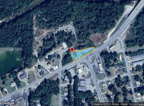
Property Record
Us Highway 31, Flomaton, AL 36441
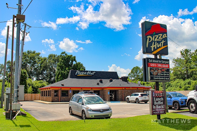
This Property Is For Sale
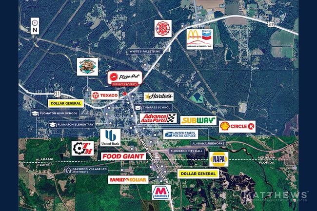
NEARBY LISTINGS FOR SALE OR LEASE
Property Detail
Us Highway 31
24-08-33-1-003-004.000
COM INT N LY R W US HWY #31 & W LINE OF SW1 4 OF NE1 4 SEC 33-T1N-R8E; TH NE L 279 (305 S) ALG SD N LY R W; S LY 11 S ALG SD N LY R W; NE LY 378 ALG SD N LY R W TO POB; TH CONT NE LY 9 S ALG SD N LY R W US HWY #31; N LY 11 S ALG SD N LY R W; NE LY 37
Restaurantbuilding
Escambia
AE
Alabama
01053C0444E
0.74 AC
2025
Alabama South Area
2024
Other Market Areas
970300
Atmore, AL
3,036 SF
DEMOGRAPHICS near Us Highway 31
1 Mile
3 Mile
5 Mile
2024 Total Population
1,024
3,892
7,012
2029 Population
1,006
3,902
7,063
Pop Growth 2024-2029
(1.76%)
+ 0.26%
+ 0.73%
Average Age
40
40
41
2024 Total Households
419
1,543
2,362
HH Growth 2024-2029
(1.67%)
+ 0.26%
+ 0.34%
Median Household Inc
$40,595
$32,859
$34,062
Avg Household Size
2.50
2.50
2.50
2024 Avg HH Vehicles
2.00
2.00
2.00
Median Home Value
$117,453
$90,051
$98,525
Median Year Built
1984
1985
1985
Nearby Places
Map Layers
Map Styles
 Street
 Aerial
- Restaurants
- Banks
- Shops
- Fitness
- Groceries
Nearby Properties
Address
Land Use
TOTAL SIZE
Lot Size
Zoning
Address
Land Use
TOTAL SIZE
Lot Size
Zoning
63,561 SF
8.37 AC
Address
Land Use
TOTAL SIZE
Lot Size
Zoning
34,538 SF
7.66 AC
INCORP
Address
Land Use
TOTAL SIZE
Lot Size
Zoning
83,668 SF
22.44 AC
INCORP
Address
Land Use
TOTAL SIZE
Lot Size
Zoning
27,844 SF
10 AC
INCORP
Address
Land Use
TOTAL SIZE
Lot Size
Zoning
38,000 SF
4.97 AC
INCORP
Address
Land Use
TOTAL SIZE
Lot Size
Zoning
7,795 SF
2.18 AC
INCORP
Address
Land Use
TOTAL SIZE
Lot Size
Zoning
4,591 SF
36.24 AC
RR
Address
Land Use
TOTAL SIZE
Lot Size
Zoning
26,362 SF
2.76 AC
INCORP
Address
Land Use
TOTAL SIZE
Lot Size
Zoning
28,667 SF
6.88 AC
INCORP
Address
Land Use
TOTAL SIZE
Lot Size
Zoning
27,430 SF
7.34 AC
INCORP
Address
Land Use
TOTAL SIZE
Lot Size
Zoning
5,551 SF
1.59 AC
INCORP
Address
Land Use
TOTAL SIZE
Lot Size
Zoning
9,230 SF
0.73 AC
INCORP
Address
Land Use
TOTAL SIZE
Lot Size
Zoning
22,654 SF
2 AC
INCORP
Address
Land Use
TOTAL SIZE
Lot Size
Zoning
8,500 SF
1.45 AC
INCORP
Address
Land Use
TOTAL SIZE
Lot Size
Zoning
8,000 SF
0.34 AC
INCORP
Address
Land Use
TOTAL SIZE
Lot Size
Zoning
19,323 SF
11.50 AC
INCORP
Address
Land Use
TOTAL SIZE
Lot Size
Zoning
4,435 SF
1.60 AC
INCORP
Address
Land Use
TOTAL SIZE
Lot Size
Zoning
12,733 SF
1 AC
INCORP
Address
Land Use
TOTAL SIZE
Lot Size
Zoning
3,051 SF
2.98 AC
INCORP
Address
Land Use
TOTAL SIZE
Lot Size
Zoning
18,668 SF
0.59 AC
Address
Land Use
TOTAL SIZE
Lot Size
Zoning
10,820 SF
1.11 AC
INCORP
Address
Land Use
TOTAL SIZE
Lot Size
Zoning
8,027 SF
24.01 AC
RR
Address
Land Use
TOTAL SIZE
Lot Size
Zoning
11,600 SF
1.11 AC
INCORP
Address
Land Use
TOTAL SIZE
Lot Size
Zoning
12,542 SF
3.92 AC
INCORP
Address
Land Use
TOTAL SIZE
Lot Size
Zoning
3,143 SF
0.96 AC
INCORP
Address
Land Use
TOTAL SIZE
Lot Size
Zoning
8,150 SF
0.62 AC
RMU
Address
Land Use
TOTAL SIZE
Lot Size
Zoning
3,606 SF
3.62 AC
INCORP
Address
Land Use
TOTAL SIZE
Lot Size
Zoning
4,200 SF
2.43 AC
INCORP
Address
Land Use
TOTAL SIZE
Lot Size
Zoning
1,333 SF
157.70 AC
RMU
Address
Land Use
TOTAL SIZE
Lot Size
Zoning
4,376 SF
119 AC
RR
The World's #1 Commercial Real Estate Marketplace
Connect with us
© 2025 CoStar Group
The information above has been obtained from sources believed reliable. While we do not doubt its accuracy we have not verified it and make no guarantee, warranty or representation about it. It is your responsibility to independently confirm its accuracy and completeness. Any projections, opinions, assumptions, or estimates used are for example only and do not represent the current or future performance of the property. The value of this transaction to you depends on tax and other factors which should be evaluated by your tax, financial, and legal advisors. You and your advisors should conduct a careful, independent investigation of the property to determine to your satisfaction the suitability of the property for your needs.