Property Record
2147 Acushnet Ave, New Bedford, MA 02745

Save to a Folder
{{folder.Name}}
{{folder.ListingIds.length}} Properties
{{folder.ListingIds.length}} Property
Create a New Folder
Property Detail
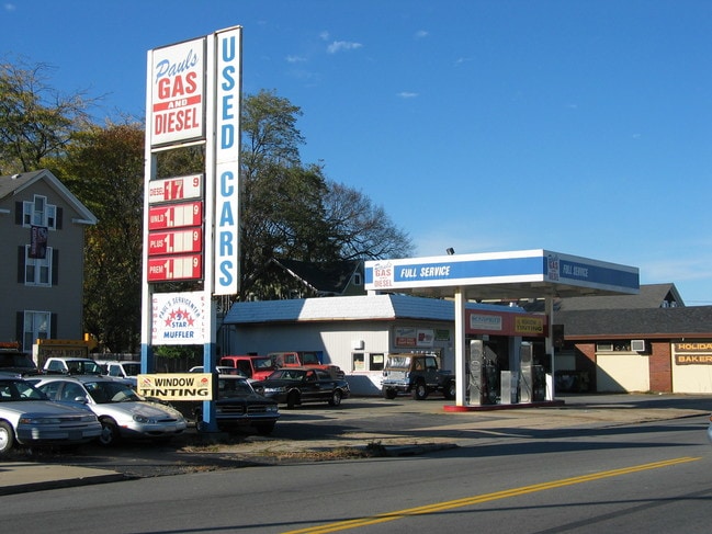
2147 Acushnet Ave
NEWB-000119-000000-000224
Bristol
Autorepair
Massachusetts
MUB
224
B and X Area of moderate flood hazard, usually the area between the limits of the 100-year and 500-year floods.
0.23 AC
2025
Attleboro/New Bedford
2025
Boston
650300
Providence-Warwick, RI-MA
2,150 SF
NEARBY LISTINGS FOR SALE OR LEASE
DEMOGRAPHICS near 2147 Acushnet Ave
1 mile
3 mile
5 mile
2025 Total Population
14,985
65,467
130,625
2030 Population
15,010
65,418
130,755
Pop Growth 2025-2030
+ 0.17%
(0.07%)
+ 0.10%
Average Age
41
40
41
2025 Total Households
6,522
27,165
53,308
HH Growth 2025-2030
+ 0.26%
(0.04%)
+ 0.11%
Median Household Inc
$70,478
$61,504
$63,657
Avg Household Size
2.20
2.30
2.30
2025 Avg HH Vehicles
2.00
2.00
2.00
Median Home Value
$352,750
$371,658
$398,791
Median Year Built
1948
1949
1949
Nearby Places
Map Layers
Map Styles
 Street
 Aerial
Layers
 Traffic
 Biking
Places
Listings with unknown addresses are not visible on the map
- Restaurants
- Banks
- Shops
- Fitness
- Groceries
PUBLIC TRANSPORTATION
AIRPORT
Rhode Island Tf Green International
Drive
Walk
Distance
Rhode Island Tf Green International
55 min
38.4 mi
SALE & LEASE HISTORY
LISTING DATE
SALE/LEASE

Jun 30, 2025
For Sale
Nearby Properties
Address
Land Use
TOTAL SIZE
Lot Size
Zoning
Address
Land Use
TOTAL SIZE
Lot Size
Zoning
23.22 AC
RB
Address
Land Use
TOTAL SIZE
Lot Size
Zoning
23.71 AC
RA
Address
Land Use
TOTAL SIZE
Lot Size
Zoning
252,482 SF
11.56 AC
RA
Address
Land Use
TOTAL SIZE
Lot Size
Zoning
243,052 SF
9.66 AC
RB
Address
Land Use
TOTAL SIZE
Lot Size
Zoning
269,020 SF
2.26 AC
MUB
Address
Land Use
TOTAL SIZE
Lot Size
Zoning
231,634 SF
2.45 AC
IB
Address
Land Use
TOTAL SIZE
Lot Size
Zoning
160,391 SF
2.86 AC
MUB
Address
Land Use
TOTAL SIZE
Lot Size
Zoning
214,698 SF
4.66 AC
IB
Address
Land Use
TOTAL SIZE
Lot Size
Zoning
24.95 AC
PB
Address
Land Use
TOTAL SIZE
Lot Size
Zoning
11.67 AC
RC
Address
Land Use
TOTAL SIZE
Lot Size
Zoning
188,739 SF
2.57 AC
IB
Address
Land Use
TOTAL SIZE
Lot Size
Zoning
134,355 SF
2.21 AC
IB
Address
Land Use
TOTAL SIZE
Lot Size
Zoning
183,196 SF
8.14 AC
MUB
Address
Land Use
TOTAL SIZE
Lot Size
Zoning
492.70 AC
IC
Address
Land Use
TOTAL SIZE
Lot Size
Zoning
119,865 SF
3.22 AC
IA
Address
Land Use
TOTAL SIZE
Lot Size
Zoning
212,875 SF
7.24 AC
WI
Address
Land Use
TOTAL SIZE
Lot Size
Zoning
116,158 SF
3.80 AC
IB
Address
Land Use
TOTAL SIZE
Lot Size
Zoning
2,190 SF
9.73 AC
IA
Address
Land Use
TOTAL SIZE
Lot Size
Zoning
225,292 SF
29.27 AC
IC
Address
Land Use
TOTAL SIZE
Lot Size
Zoning
8.69 AC
RA
Address
Land Use
TOTAL SIZE
Lot Size
Zoning
5,616 SF
132.66 AC
RA
Address
Land Use
TOTAL SIZE
Lot Size
Zoning
306.30 AC
IC
Address
Land Use
TOTAL SIZE
Lot Size
Zoning
6.46 AC
MUB
Address
Land Use
TOTAL SIZE
Lot Size
Zoning
165,183 SF
11.29 AC
PB
Address
Land Use
TOTAL SIZE
Lot Size
Zoning
3.15 AC
RA
Address
Land Use
TOTAL SIZE
Lot Size
Zoning
5.49 AC
RB
Address
Land Use
TOTAL SIZE
Lot Size
Zoning
85.25 AC
MUB
Address
Land Use
TOTAL SIZE
Lot Size
Zoning
5.30 AC
RC
Address
Land Use
TOTAL SIZE
Lot Size
Zoning
20.70 AC
I
Address
Land Use
TOTAL SIZE
Lot Size
Zoning
39,910 SF
2.29 AC
RB
The World's #1 Commercial Real Estate Marketplace
Connect with us
© 2026 CoStar Group
The information above has been obtained from sources believed reliable. While we do not doubt its accuracy we have not verified it and make no guarantee, warranty or representation about it. It is your responsibility to independently confirm its accuracy and completeness. Any projections, opinions, assumptions, or estimates used are for example only and do not represent the current or future performance of the property. The value of this transaction to you depends on tax and other factors which should be evaluated by your tax, financial, and legal advisors. You and your advisors should conduct a careful, independent investigation of the property to determine to your satisfaction the suitability of the property for your needs.