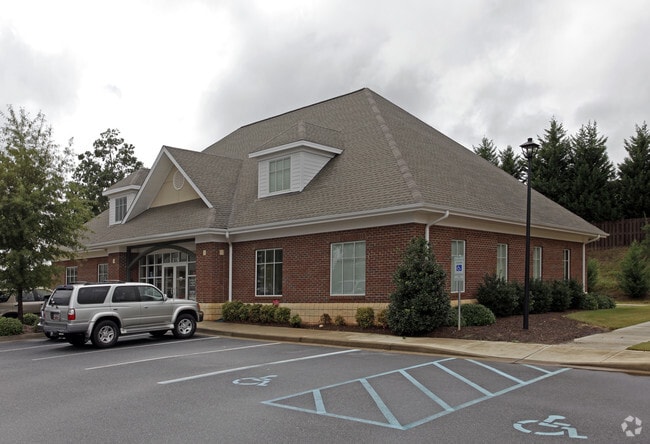
Property Record
215 Batesville Rd, Simpsonville, SC 29681


Current Lease Availabilities
NEARBY LISTINGS FOR SALE OR LEASE
Property Detail
215 Batesville Rd
Greenville-Anderson-Mauldin, SC
The Oaks At Five Forks
0531.03-01-038.06
MAP 0531.03; 2
Medicalbuilding
Greenville
X
South Carolina
45045C0436E
038.06
2025
0.12 AC
2024
Woodruff/I-385 Corridor
002813
Greenville/Spartanburg
DEMOGRAPHICS near 215 Batesville Rd
1 Mile
3 Mile
5 Mile
2024 Total Population
6,482
50,064
111,853
2029 Population
7,069
54,814
123,250
Pop Growth 2024-2029
+ 9.06%
+ 9.49%
+ 10.19%
Average Age
42
41
40
2024 Total Households
2,305
18,265
43,352
HH Growth 2024-2029
+ 9.15%
+ 9.62%
+ 10.31%
Median Household Inc
$129,667
$111,935
$94,443
Avg Household Size
2.80
2.70
2.50
2024 Avg HH Vehicles
2.00
2.00
2.00
Median Home Value
$412,310
$307,138
$290,060
Median Year Built
2001
1999
1999
Nearby Places
Map Layers
Map Styles
 Street
 Aerial
- Restaurants
- Banks
- Shops
- Fitness
- Groceries
PUBLIC TRANSPORTATION
AIRPORT
Greenville Spartanburg International
DRIVE
WALK
Distance
Greenville Spartanburg International
14 min
6.7 mi
Freight Ports
North Charleston Terminal
DRIVE
WALK
Distance
North Charleston Terminal
226 min
198.7 mi
Nearby Properties
Address
Land Use
TOTAL SIZE
Lot Size
Zoning
Address
Land Use
TOTAL SIZE
Lot Size
Zoning
16 AC
S1
Address
Land Use
TOTAL SIZE
Lot Size
Zoning
22.50 AC
S1
Address
Land Use
TOTAL SIZE
Lot Size
Zoning
2,355 SF
10.21 AC
RS
Address
Land Use
TOTAL SIZE
Lot Size
Zoning
7.53 AC
S1
Address
Land Use
TOTAL SIZE
Lot Size
Zoning
11.05 AC
S1
Address
Land Use
TOTAL SIZE
Lot Size
Zoning
6.27 AC
UVD
Address
Land Use
TOTAL SIZE
Lot Size
Zoning
38.86 AC
C2
Address
Land Use
TOTAL SIZE
Lot Size
Zoning
181.61 AC
C-2,I1
Address
Land Use
TOTAL SIZE
Lot Size
Zoning
17.53 AC
I1
Address
Land Use
TOTAL SIZE
Lot Size
Zoning
Address
Land Use
TOTAL SIZE
Lot Size
Zoning
5.19 AC
PD
Address
Land Use
TOTAL SIZE
Lot Size
Zoning
5.47 AC
C3
Address
Land Use
TOTAL SIZE
Lot Size
Zoning
24.12 AC
S1
Address
Land Use
TOTAL SIZE
Lot Size
Zoning
301 AC
RS
Address
Land Use
TOTAL SIZE
Lot Size
Zoning
91.80 AC
PD
Address
Land Use
TOTAL SIZE
Lot Size
Zoning
4.80 AC
I1
Address
Land Use
TOTAL SIZE
Lot Size
Zoning
50.13 AC
RM,S1
Address
Land Use
TOTAL SIZE
Lot Size
Zoning
9.90 AC
I1
Address
Land Use
TOTAL SIZE
Lot Size
Zoning
2.73 AC
C3
Address
Land Use
TOTAL SIZE
Lot Size
Zoning
4,128 SF
25.54 AC
RS
Address
Land Use
TOTAL SIZE
Lot Size
Zoning
1,242 SF
26.57 AC
RS
Address
Land Use
TOTAL SIZE
Lot Size
Zoning
2.97 AC
S1
Address
Land Use
TOTAL SIZE
Lot Size
Zoning
2.86 AC
S1
Address
Land Use
TOTAL SIZE
Lot Size
Zoning
Address
Land Use
TOTAL SIZE
Lot Size
Zoning
26.29 AC
RS
Address
Land Use
TOTAL SIZE
Lot Size
Zoning
7.20 AC
R20
Address
Land Use
TOTAL SIZE
Lot Size
Zoning
6.64 AC
RS
Address
Land Use
TOTAL SIZE
Lot Size
Zoning
17.21 AC
RM20
Address
Land Use
TOTAL SIZE
Lot Size
Zoning
34.33 AC
RS
Address
Land Use
TOTAL SIZE
Lot Size
Zoning
16.71 AC
RM10
The World's #1 Commercial Real Estate Marketplace
Connect with us
© 2026 CoStar Group
The information above has been obtained from sources believed reliable. While we do not doubt its accuracy we have not verified it and make no guarantee, warranty or representation about it. It is your responsibility to independently confirm its accuracy and completeness. Any projections, opinions, assumptions, or estimates used are for example only and do not represent the current or future performance of the property. The value of this transaction to you depends on tax and other factors which should be evaluated by your tax, financial, and legal advisors. You and your advisors should conduct a careful, independent investigation of the property to determine to your satisfaction the suitability of the property for your needs.