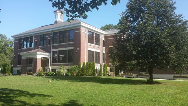
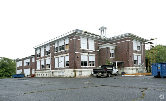
Property Record
215 Broad St, Eatontown, NJ 07724


Current Lease Availabilities
Property Detail
215 Broad St
12-00301-0000-00051
FACILITY NAME: SCHOOLS
Publicschool
MONMOUTH
CONREC
New Jersey
B and X Area of moderate flood hazard, usually the area between the limits of the 100-year and 500-year floods.
51
2024
2.07 AC
2025
Eastern Monmouth
812200
Northern New Jersey
14,482 SF
Lakewood-New Brunswick, NJ
NEARBY LISTINGS FOR SALE OR LEASE
DEMOGRAPHICS near 215 Broad St
1 mile
3 mile
5 mile
2025 Total Population
7,111
68,914
154,943
2030 Population
7,147
68,760
155,675
Pop Growth 2025-2030
+ 0.51%
(0.22%)
+ 0.47%
Average Age
43
41
42
2025 Total Households
3,053
25,975
60,140
HH Growth 2025-2030
+ 0.33%
(0.38%)
+ 0.37%
Median Household Inc
$93,612
$107,837
$110,930
Avg Household Size
2.30
2.50
2.50
2025 Avg HH Vehicles
2.00
2.00
2.00
Median Home Value
$472,992
$684,236
$728,621
Median Year Built
1974
1968
1971
Nearby Places
Map Layers
Map Styles
 Street
 Aerial
Layers
 Traffic
 Biking
Places
Listings with unknown addresses are not visible on the map
- Restaurants
- Banks
- Shops
- Fitness
- Groceries
PUBLIC TRANSPORTATION
COMMUTER RAIL
Little Silver (North Jersey Coast Line - NJ Transit Commuter Rail (NJ Transit))
Drive
Walk
Distance
Little Silver (North Jersey Coast Line - NJ Transit Commuter Rail (NJ Transit))
5 min
2.6 mi
Red Bank (North Jersey Coast Line - NJ Transit Commuter Rail (NJ Transit))
Drive
Walk
Distance
Red Bank (North Jersey Coast Line - NJ Transit Commuter Rail (NJ Transit))
8 min
4.0 mi
AIRPORT
Newark Liberty International
Drive
Walk
Distance
Newark Liberty International
55 min
43.7 mi
Freight Ports
New York Container Terminal
Drive
Walk
Distance
New York Container Terminal
49 min
35.8 mi
Nearby Properties
Address
Land Use
TOTAL SIZE
Lot Size
Zoning
Address
Land Use
TOTAL SIZE
Lot Size
Zoning
221.56 AC
CONREC
Address
Land Use
TOTAL SIZE
Lot Size
Zoning
75.16 AC
MF08
Address
Land Use
TOTAL SIZE
Lot Size
Zoning
Address
Land Use
TOTAL SIZE
Lot Size
Zoning
136.40 AC
B2
Address
Land Use
TOTAL SIZE
Lot Size
Zoning
22,877 SF
10.35 AC
IC
Address
Land Use
TOTAL SIZE
Lot Size
Zoning
84,653 SF
20.79 AC
C50
Address
Land Use
TOTAL SIZE
Lot Size
Zoning
2,446 SF
21.62 AC
R-5
Address
Land Use
TOTAL SIZE
Lot Size
Zoning
293,262 SF
28.40 AC
HC
Address
Land Use
TOTAL SIZE
Lot Size
Zoning
24.45 AC
MF08
Address
Land Use
TOTAL SIZE
Lot Size
Zoning
22,980 SF
5.27 AC
MU0
Address
Land Use
TOTAL SIZE
Lot Size
Zoning
194,812 SF
55.01 AC
MF15
Address
Land Use
TOTAL SIZE
Lot Size
Zoning
35.98 AC
MF08
Address
Land Use
TOTAL SIZE
Lot Size
Zoning
178,315 SF
24.54 AC
C50
Address
Land Use
TOTAL SIZE
Lot Size
Zoning
27 AC
MF08
Address
Land Use
TOTAL SIZE
Lot Size
Zoning
153,160 SF
10.12 AC
OB01
Address
Land Use
TOTAL SIZE
Lot Size
Zoning
14.23 AC
R-4
Address
Land Use
TOTAL SIZE
Lot Size
Zoning
181,867 SF
31.90 AC
RA
Address
Land Use
TOTAL SIZE
Lot Size
Zoning
77.36 AC
B2
Address
Land Use
TOTAL SIZE
Lot Size
Zoning
258,088 SF
27.90 AC
IO20
Address
Land Use
TOTAL SIZE
Lot Size
Zoning
142,311 SF
40.82 AC
I
Address
Land Use
TOTAL SIZE
Lot Size
Zoning
12,269 SF
3.60 AC
OVERLAY
Address
Land Use
TOTAL SIZE
Lot Size
Zoning
14.99 AC
MF08
Address
Land Use
TOTAL SIZE
Lot Size
Zoning
108,629 SF
12.05 AC
HC
Address
Land Use
TOTAL SIZE
Lot Size
Zoning
132,378 SF
8.10 AC
OB01
Address
Land Use
TOTAL SIZE
Lot Size
Zoning
14.73 AC
MF08
Address
Land Use
TOTAL SIZE
Lot Size
Zoning
101,880 SF
6 AC
SF05
Address
Land Use
TOTAL SIZE
Lot Size
Zoning
36.22 AC
SF10
Address
Land Use
TOTAL SIZE
Lot Size
Zoning
22,522 SF
6.25 AC
I
Address
Land Use
TOTAL SIZE
Lot Size
Zoning
101,700 SF
10.54 AC
OB01
Address
Land Use
TOTAL SIZE
Lot Size
Zoning
86,586 SF
4.83 AC
R-4
The World's #1 Commercial Real Estate Marketplace
Connect with us
© 2026 CoStar Group
The information above has been obtained from sources believed reliable. While we do not doubt its accuracy we have not verified it and make no guarantee, warranty or representation about it. It is your responsibility to independently confirm its accuracy and completeness. Any projections, opinions, assumptions, or estimates used are for example only and do not represent the current or future performance of the property. The value of this transaction to you depends on tax and other factors which should be evaluated by your tax, financial, and legal advisors. You and your advisors should conduct a careful, independent investigation of the property to determine to your satisfaction the suitability of the property for your needs.