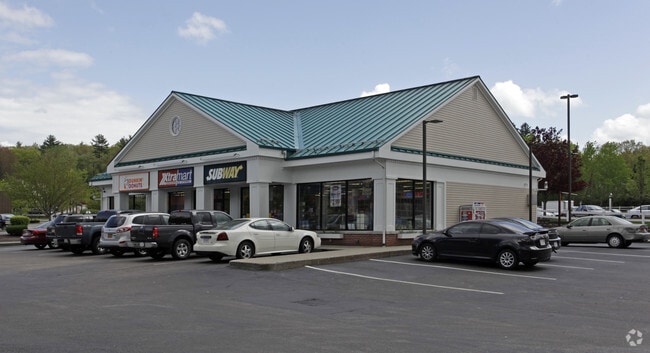
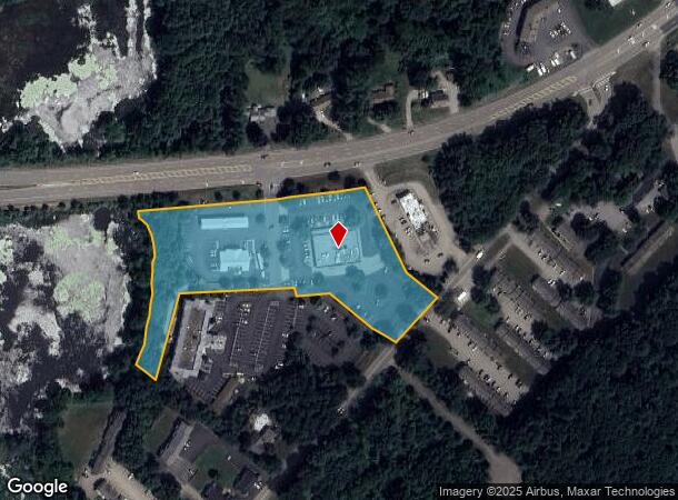
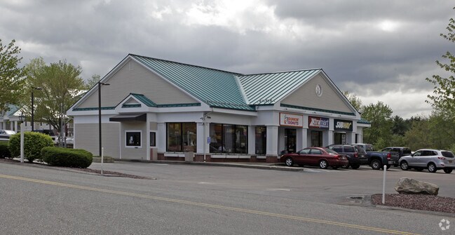
Property Record
215 Charlton Rd, Sturbridge, MA 01566
NEARBY LISTINGS FOR SALE OR LEASE
Property Detail
215 Charlton Rd
STUR-000208-000000-002538-000215
Worcester
Commercialnec
Massachusetts
A
2538
09015C0025F
4.37 AC
2025
Outlying Worcester
2025
Boston
758104
Worcester, MA-CT
10,148 SF
DEMOGRAPHICS near 215 Charlton Rd
1 Mile
3 Mile
5 Mile
2024 Total Population
1,441
13,811
32,537
2029 Population
1,459
13,764
32,373
Pop Growth 2024-2029
+ 1.25%
(0.34%)
(0.50%)
Average Age
41
41
42
2024 Total Households
564
5,582
13,172
HH Growth 2024-2029
+ 1.06%
(0.39%)
(0.53%)
Median Household Inc
$140,322
$80,649
$73,231
Avg Household Size
2.50
2.40
2.40
2024 Avg HH Vehicles
2.00
2.00
2.00
Median Home Value
$414,930
$354,658
$334,191
Median Year Built
1983
1969
1967
Nearby Places
Map Layers
Map Styles
 Street
 Aerial
- Restaurants
- Banks
- Shops
- Fitness
- Groceries
PUBLIC TRANSPORTATION
AIRPORT
Worcester Regional
DRIVE
WALK
Distance
Worcester Regional
36 min
21.3 mi
Freight Ports
Port of Davisville, RI
DRIVE
WALK
Distance
Port of Davisville, RI
94 min
72.5 mi
Nearby Properties
Address
Land Use
TOTAL SIZE
Lot Size
Zoning
Address
Land Use
TOTAL SIZE
Lot Size
Zoning
1,800 SF
10.02 AC
IG
Address
Land Use
TOTAL SIZE
Lot Size
Zoning
15,648 SF
50.82 AC
A
Address
Land Use
TOTAL SIZE
Lot Size
Zoning
127,762 SF
19.28 AC
Address
Land Use
TOTAL SIZE
Lot Size
Zoning
127,620 SF
6.40 AC
R2
Address
Land Use
TOTAL SIZE
Lot Size
Zoning
45.13 AC
GB
Address
Land Use
TOTAL SIZE
Lot Size
Zoning
102,966 SF
30.95 AC
Address
Land Use
TOTAL SIZE
Lot Size
Zoning
Address
Land Use
TOTAL SIZE
Lot Size
Zoning
2.14 AC
CC
Address
Land Use
TOTAL SIZE
Lot Size
Zoning
93,260 SF
9.10 AC
R1
Address
Land Use
TOTAL SIZE
Lot Size
Zoning
208,444 SF
14.09 AC
Address
Land Use
TOTAL SIZE
Lot Size
Zoning
40,910 SF
25.36 AC
Address
Land Use
TOTAL SIZE
Lot Size
Zoning
Address
Land Use
TOTAL SIZE
Lot Size
Zoning
195.60 AC
IG
Address
Land Use
TOTAL SIZE
Lot Size
Zoning
4,704 SF
76 AC
Address
Land Use
TOTAL SIZE
Lot Size
Zoning
105,660 SF
Address
Land Use
TOTAL SIZE
Lot Size
Zoning
93,552 SF
40.84 AC
Address
Land Use
TOTAL SIZE
Lot Size
Zoning
15,000 SF
2 AC
Address
Land Use
TOTAL SIZE
Lot Size
Zoning
5,024 SF
10.60 AC
Address
Land Use
TOTAL SIZE
Lot Size
Zoning
1 AC
CC
Address
Land Use
TOTAL SIZE
Lot Size
Zoning
43,817 SF
3.17 AC
Address
Land Use
TOTAL SIZE
Lot Size
Zoning
56,336 SF
5 AC
GB
Address
Land Use
TOTAL SIZE
Lot Size
Zoning
55,530 SF
4.74 AC
Address
Land Use
TOTAL SIZE
Lot Size
Zoning
68,898 SF
49.02 AC
Address
Land Use
TOTAL SIZE
Lot Size
Zoning
768 SF
12.90 AC
R1
Address
Land Use
TOTAL SIZE
Lot Size
Zoning
42,098 SF
2.95 AC
OR
Address
Land Use
TOTAL SIZE
Lot Size
Zoning
76,734 SF
7.75 AC
IG
Address
Land Use
TOTAL SIZE
Lot Size
Zoning
226.35 AC
M
Address
Land Use
TOTAL SIZE
Lot Size
Zoning
52,255 SF
Address
Land Use
TOTAL SIZE
Lot Size
Zoning
36,220 SF
1.42 AC
Address
Land Use
TOTAL SIZE
Lot Size
Zoning
65,104 SF
9.60 AC
The World's #1 Commercial Real Estate Marketplace
Connect with us
© 2026 CoStar Group
The information above has been obtained from sources believed reliable. While we do not doubt its accuracy we have not verified it and make no guarantee, warranty or representation about it. It is your responsibility to independently confirm its accuracy and completeness. Any projections, opinions, assumptions, or estimates used are for example only and do not represent the current or future performance of the property. The value of this transaction to you depends on tax and other factors which should be evaluated by your tax, financial, and legal advisors. You and your advisors should conduct a careful, independent investigation of the property to determine to your satisfaction the suitability of the property for your needs.