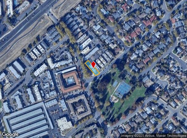
Property Record
215 Coventry Dr, Stockton, CA 95207
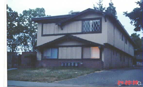

This Property Is For Sale
NEARBY LISTINGS FOR SALE OR LEASE
Property Detail
215 Coventry Dr
Stockton-Lodi, CA
Weberstown 07
104-110-10
REDRAW 851121 FR ORIG APN 099190100
Quadruplex
San Joaquin
X
California
06077C0460F
413
2025
0.17 AC
2025
Weberstown/Kentfield
003312
Stockton/Modesto
4,508 SF
DEMOGRAPHICS near 215 Coventry Dr
1 Mile
3 Mile
5 Mile
2024 Total Population
23,723
187,654
336,709
2029 Population
25,132
197,809
355,080
Pop Growth 2024-2029
+ 5.94%
+ 5.41%
+ 5.46%
Average Age
36
36
37
2024 Total Households
7,906
62,151
106,152
HH Growth 2024-2029
+ 5.92%
+ 5.52%
+ 5.54%
Median Household Inc
$52,566
$63,445
$67,912
Avg Household Size
2.80
2.90
3.00
2024 Avg HH Vehicles
2.00
2.00
2.00
Median Home Value
$327,872
$347,773
$377,478
Median Year Built
1971
1971
1975
Nearby Places
- Restaurants
- Banks
- Shops
- Fitness
- Groceries
PUBLIC TRANSPORTATION
COMMUTER RAIL
Stockton (Altamont Corridor Express - Altamont Commuter Express (ACE))
DRIVE
WALK
Distance
Stockton (Altamont Corridor Express - Altamont Commuter Express (ACE))
9 min
4.1 mi
DRIVE
WALK
Distance
10 min
4.4 mi
AIRPORT
Stockton Metro
DRIVE
WALK
Distance
Stockton Metro
18 min
9.3 mi
Freight Ports
Port of Stockton
DRIVE
WALK
Distance
Port of Stockton
11 min
5.0 mi
Nearby Properties
Address
Land Use
TOTAL SIZE
Lot Size
Zoning
Address
Land Use
TOTAL SIZE
Lot Size
Zoning
530,700 SF
8.35 AC
Address
Land Use
TOTAL SIZE
Lot Size
Zoning
30,080 SF
82.44 AC
Address
Land Use
TOTAL SIZE
Lot Size
Zoning
105,083 SF
24.90 AC
O
Address
Land Use
TOTAL SIZE
Lot Size
Zoning
152,000 SF
1.31 AC
Address
Land Use
TOTAL SIZE
Lot Size
Zoning
4.78 AC
Address
Land Use
TOTAL SIZE
Lot Size
Zoning
10,208 SF
47.57 AC
Address
Land Use
TOTAL SIZE
Lot Size
Zoning
9,750 SF
136.94 AC
AU20
Address
Land Use
TOTAL SIZE
Lot Size
Zoning
22.89 AC
Address
Land Use
TOTAL SIZE
Lot Size
Zoning
254,378 SF
17.07 AC
Address
Land Use
TOTAL SIZE
Lot Size
Zoning
121,574 SF
5.49 AC
RHD
Address
Land Use
TOTAL SIZE
Lot Size
Zoning
23,112 SF
9.20 AC
Address
Land Use
TOTAL SIZE
Lot Size
Zoning
207,540 SF
21.16 AC
Address
Land Use
TOTAL SIZE
Lot Size
Zoning
82,512 SF
4.14 AC
Address
Land Use
TOTAL SIZE
Lot Size
Zoning
1,312 SF
7.44 AC
Address
Land Use
TOTAL SIZE
Lot Size
Zoning
14,212 SF
26.11 AC
Address
Land Use
TOTAL SIZE
Lot Size
Zoning
107,184 SF
34.13 AC
Address
Land Use
TOTAL SIZE
Lot Size
Zoning
97,276 SF
5.46 AC
RHD
Address
Land Use
TOTAL SIZE
Lot Size
Zoning
8,000 SF
0.67 AC
Address
Land Use
TOTAL SIZE
Lot Size
Zoning
89,725 SF
4.02 AC
Address
Land Use
TOTAL SIZE
Lot Size
Zoning
190,923 SF
3.96 AC
Address
Land Use
TOTAL SIZE
Lot Size
Zoning
0.79 AC
Address
Land Use
TOTAL SIZE
Lot Size
Zoning
37,846 SF
2.94 AC
Address
Land Use
TOTAL SIZE
Lot Size
Zoning
51,892 SF
5.33 AC
Address
Land Use
TOTAL SIZE
Lot Size
Zoning
52,644 SF
2 AC
Address
Land Use
TOTAL SIZE
Lot Size
Zoning
14,035 SF
10.02 AC
Address
Land Use
TOTAL SIZE
Lot Size
Zoning
117,320 SF
2.86 AC
Address
Land Use
TOTAL SIZE
Lot Size
Zoning
77,568 SF
2.58 AC
Address
Land Use
TOTAL SIZE
Lot Size
Zoning
2.42 AC
Address
Land Use
TOTAL SIZE
Lot Size
Zoning
2,876 SF
10.54 AC
Address
Land Use
TOTAL SIZE
Lot Size
Zoning
67,195 SF
5.30 AC
The World's #1 Commercial Real Estate Marketplace
Connect with us
© 2025 CoStar Group
The information above has been obtained from sources believed reliable. While we do not doubt its accuracy we have not verified it and make no guarantee, warranty or representation about it. It is your responsibility to independently confirm its accuracy and completeness. Any projections, opinions, assumptions, or estimates used are for example only and do not represent the current or future performance of the property. The value of this transaction to you depends on tax and other factors which should be evaluated by your tax, financial, and legal advisors. You and your advisors should conduct a careful, independent investigation of the property to determine to your satisfaction the suitability of the property for your needs.