Property Record
215 Depot Rd, Coventry, CT 06238
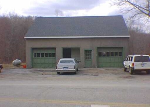

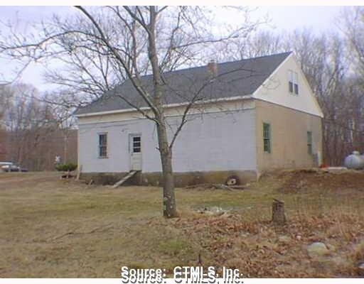
Property Detail
215 Depot Rd
COVE-000025-000051-000011
Capitol
Commercialbuilding
Connecticut
R/A
43
2025
4.38 AC
2025
Tolland County
850200
Hartford
1,632 SF
Hartford-West Hartford-East Hartford, CT
NEARBY LISTINGS FOR SALE OR LEASE
-
-
View all Coventry listings for sale on LoopNet.com
DEMOGRAPHICS near 215 Depot Rd
1 mile
3 mile
5 mile
2025 Total Population
861
12,363
54,517
2030 Population
883
12,729
55,773
Pop Growth 2025-2030
+ 2.56%
+ 2.96%
+ 2.30%
Average Age
43
39
35
2025 Total Households
348
4,259
16,897
HH Growth 2025-2030
+ 2.30%
+ 3.43%
+ 2.79%
Median Household Inc
$108,495
$99,722
$65,608
Avg Household Size
2.40
2.30
2.30
2025 Avg HH Vehicles
2.00
2.00
2.00
Median Home Value
$337,209
$330,189
$299,660
Median Year Built
1957
1970
1970
Nearby Places
Map Layers
Map Styles
 Street
 Aerial
Transit
 Traffic
 Biking
Places
Listings with unknown addresses are not visible on the map
- Restaurants
- Banks
- Shops
- Fitness
- Groceries
PUBLIC TRANSPORTATION
AIRPORT
Bradley International
Drive
Walk
Distance
Bradley International
62 min
38.1 mi
Freight Ports
Port of Davisville, RI
Drive
Walk
Distance
Port of Davisville, RI
89 min
65.6 mi
Nearby Properties
Address
Land Use
TOTAL SIZE
Lot Size
Zoning
Address
Land Use
TOTAL SIZE
Lot Size
Zoning
253,885 SF
I
Address
Land Use
TOTAL SIZE
Lot Size
Zoning
257,360 SF
1 AC
I
Address
Land Use
TOTAL SIZE
Lot Size
Zoning
120,135 SF
Address
Land Use
TOTAL SIZE
Lot Size
Zoning
153,234 SF
1 AC
I
Address
Land Use
TOTAL SIZE
Lot Size
Zoning
213,280 SF
1 AC
I
Address
Land Use
TOTAL SIZE
Lot Size
Zoning
203,904 SF
1 AC
I
Address
Land Use
TOTAL SIZE
Lot Size
Zoning
111,455 SF
1 AC
I
Address
Land Use
TOTAL SIZE
Lot Size
Zoning
255,750 SF
1 AC
I
Address
Land Use
TOTAL SIZE
Lot Size
Zoning
227,479 SF
2 AC
I
Address
Land Use
TOTAL SIZE
Lot Size
Zoning
Address
Land Use
TOTAL SIZE
Lot Size
Zoning
Address
Land Use
TOTAL SIZE
Lot Size
Zoning
Address
Land Use
TOTAL SIZE
Lot Size
Zoning
115,104 SF
1 AC
I
Address
Land Use
TOTAL SIZE
Lot Size
Zoning
88,000 SF
1 AC
Address
Land Use
TOTAL SIZE
Lot Size
Zoning
98 AC
GR40
Address
Land Use
TOTAL SIZE
Lot Size
Zoning
93.53 AC
RAR90
Address
Land Use
TOTAL SIZE
Lot Size
Zoning
120,939 SF
I
Address
Land Use
TOTAL SIZE
Lot Size
Zoning
54,072 SF
1 AC
I
Address
Land Use
TOTAL SIZE
Lot Size
Zoning
49,319 SF
1 AC
I
Address
Land Use
TOTAL SIZE
Lot Size
Zoning
405,600 SF
2 AC
I
Address
Land Use
TOTAL SIZE
Lot Size
Zoning
33,278 SF
1 AC
Address
Land Use
TOTAL SIZE
Lot Size
Zoning
60,036 SF
1 AC
I
Address
Land Use
TOTAL SIZE
Lot Size
Zoning
37,488 SF
I
Address
Land Use
TOTAL SIZE
Lot Size
Zoning
35,127 SF
I
Address
Land Use
TOTAL SIZE
Lot Size
Zoning
35,127 SF
I
Address
Land Use
TOTAL SIZE
Lot Size
Zoning
35,127 SF
I
Address
Land Use
TOTAL SIZE
Lot Size
Zoning
35,127 SF
I
Address
Land Use
TOTAL SIZE
Lot Size
Zoning
35,127 SF
I
Address
Land Use
TOTAL SIZE
Lot Size
Zoning
34,014 SF
I
Address
Land Use
TOTAL SIZE
Lot Size
Zoning
46,911 SF
6.98 AC
I
The World's #1 Commercial Real Estate Marketplace
Connect with us
© 2026 CoStar Group
The information above has been obtained from sources believed reliable. While we do not doubt its accuracy we have not verified it and make no guarantee, warranty or representation about it. It is your responsibility to independently confirm its accuracy and completeness. Any projections, opinions, assumptions, or estimates used are for example only and do not represent the current or future performance of the property. The value of this transaction to you depends on tax and other factors which should be evaluated by your tax, financial, and legal advisors. You and your advisors should conduct a careful, independent investigation of the property to determine to your satisfaction the suitability of the property for your needs.