Property Record
215 E Baseline Rd, Gilbert, AZ 85233
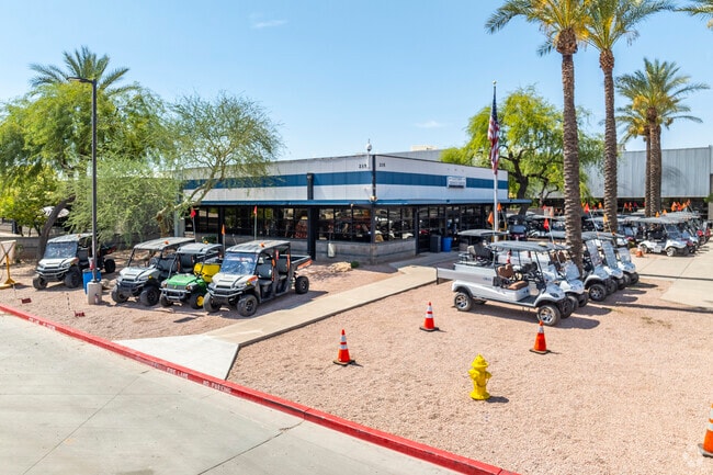

Property Detail
215 E Baseline Rd
302-10-007C
TH PT W2 LOT 1 (AKA W2 NE4 NE4 SEC 3) LY N OF N R/W LN S P R R EX N 65F RD & EX E 217.15F TH/OF AS MEAS ALG N LN LOT 1
Autorepair
Maricopa
I-1
Arizona
AH Areas with a 1% annual chance of shallow flooding, usually in the form of a pond, withan average depth ranging from 1 to 3 feet. These areas have a 26% chance of flooding over the life of a 30-year mortgage.
1
2025
6.30 AC
2025
Chandler N/Gilbert
422307
Phoenix
37,870 SF
Phoenix-Mesa-Chandler, AZ
NEARBY LISTINGS FOR SALE OR LEASE
DEMOGRAPHICS near 215 E Baseline Rd
1 mile
3 mile
5 mile
2024 Total Population
5,866
155,625
432,131
2029 Population
6,032
160,305
446,162
Pop Growth 2024-2029
+ 2.83%
+ 3.01%
+ 3.25%
Average Age
36
36
38
2024 Total Households
2,142
58,143
163,098
HH Growth 2024-2029
+ 2.80%
+ 3.05%
+ 3.41%
Median Household Inc
$73,979
$72,063
$80,909
Avg Household Size
2.60
2.60
2.60
2024 Avg HH Vehicles
2.00
2.00
2.00
Median Home Value
$442,090
$418,285
$430,363
Median Year Built
1986
1983
1984
Nearby Places
Map Layers
Map Styles
 Street
 Aerial
Transit
 Traffic
 Biking
Places
Listings with unknown addresses are not visible on the map
- Restaurants
- Banks
- Shops
- Fitness
- Groceries
PUBLIC TRANSPORTATION
AIRPORT
Phoenix Sky Harbor International
Drive
Walk
Distance
Phoenix Sky Harbor International
23 min
15.1 mi
Phoenix-Mesa Gateway
Drive
Walk
Distance
Phoenix-Mesa Gateway
24 min
15.2 mi
Freight Ports
Port of San Diego
Drive
Walk
Distance
Port of San Diego
410 min
373.4 mi
Nearby Properties
Address
Land Use
TOTAL SIZE
Lot Size
Zoning
Address
Land Use
TOTAL SIZE
Lot Size
Zoning
439,211 SF
77.92 AC
C-G
Address
Land Use
TOTAL SIZE
Lot Size
Zoning
7.90 AC
Address
Land Use
TOTAL SIZE
Lot Size
Zoning
184,558 SF
6.18 AC
Address
Land Use
TOTAL SIZE
Lot Size
Zoning
127,962 SF
18.60 AC
I-1
Address
Land Use
TOTAL SIZE
Lot Size
Zoning
1,418,890 SF
39 AC
PF
Address
Land Use
TOTAL SIZE
Lot Size
Zoning
5.92 AC
I-1
Address
Land Use
TOTAL SIZE
Lot Size
Zoning
805,814 SF
115.19 AC
C-G
Address
Land Use
TOTAL SIZE
Lot Size
Zoning
4.96 AC
Address
Land Use
TOTAL SIZE
Lot Size
Zoning
30,075 SF
6.86 AC
I-1
Address
Land Use
TOTAL SIZE
Lot Size
Zoning
301,190 SF
77.17 AC
PF
Address
Land Use
TOTAL SIZE
Lot Size
Zoning
377,442 SF
0.21 AC
C-DT
Address
Land Use
TOTAL SIZE
Lot Size
Zoning
739,944 SF
40.02 AC
MFM
Address
Land Use
TOTAL SIZE
Lot Size
Zoning
9.25 AC
I-1
Address
Land Use
TOTAL SIZE
Lot Size
Zoning
62,328 SF
2.65 AC
Address
Land Use
TOTAL SIZE
Lot Size
Zoning
281,301 SF
19.13 AC
I-1
Address
Land Use
TOTAL SIZE
Lot Size
Zoning
15,050 SF
1.42 AC
C-G
Address
Land Use
TOTAL SIZE
Lot Size
Zoning
13,336 SF
1.98 AC
I-2
Address
Land Use
TOTAL SIZE
Lot Size
Zoning
411,683 SF
15.53 AC
RM3
Address
Land Use
TOTAL SIZE
Lot Size
Zoning
357,952 SF
33.73 AC
LI
Address
Land Use
TOTAL SIZE
Lot Size
Zoning
418,678 SF
18.63 AC
C-G
Address
Land Use
TOTAL SIZE
Lot Size
Zoning
112,628 SF
17.37 AC
I-1
Address
Land Use
TOTAL SIZE
Lot Size
Zoning
309,031 SF
18.55 AC
Address
Land Use
TOTAL SIZE
Lot Size
Zoning
454,015 SF
10.03 AC
DB1
Address
Land Use
TOTAL SIZE
Lot Size
Zoning
16.57 AC
PF
Address
Land Use
TOTAL SIZE
Lot Size
Zoning
427,210 SF
38.33 AC
PF
Address
Land Use
TOTAL SIZE
Lot Size
Zoning
572,119 SF
22.45 AC
PF
Address
Land Use
TOTAL SIZE
Lot Size
Zoning
344,641 SF
21.43 AC
I-1
Address
Land Use
TOTAL SIZE
Lot Size
Zoning
16,133 SF
1.79 AC
PF
Address
Land Use
TOTAL SIZE
Lot Size
Zoning
315,463 SF
9.85 AC
C-G
Address
Land Use
TOTAL SIZE
Lot Size
Zoning
348,151 SF
20.69 AC
LI
The World's #1 Commercial Real Estate Marketplace
Connect with us
© 2026 CoStar Group
The information above has been obtained from sources believed reliable. While we do not doubt its accuracy we have not verified it and make no guarantee, warranty or representation about it. It is your responsibility to independently confirm its accuracy and completeness. Any projections, opinions, assumptions, or estimates used are for example only and do not represent the current or future performance of the property. The value of this transaction to you depends on tax and other factors which should be evaluated by your tax, financial, and legal advisors. You and your advisors should conduct a careful, independent investigation of the property to determine to your satisfaction the suitability of the property for your needs.