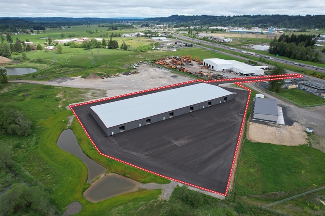
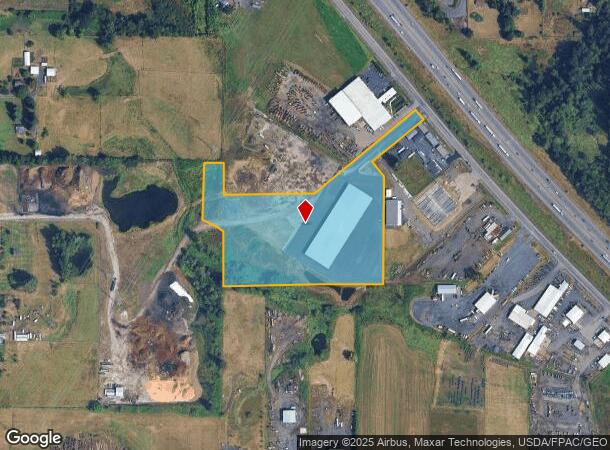
Property Record
215 Hamilton Rd N, Chehalis, WA 98532

Current Lease Availabilities
NEARBY LISTINGS FOR SALE OR LEASE
-
-
View all Chehalis listings for lease on LoopNet.com
Property Detail
215 Hamilton Rd N
017896-006-010
SECTION 15 TOWNSHIP 13N RANGE 02W PT NW4 NW4 SWLY HAMILTON RD
Residentialacreage
Lewis
AE
Washington
5301021781C
4.47 AC
2024
Washington State Area
2024
Other Market Areas
971400
Centralia, WA
DEMOGRAPHICS near 215 Hamilton Rd N
1 Mile
3 Mile
5 Mile
2024 Total Population
311
10,801
20,024
2029 Population
327
11,217
20,741
Pop Growth 2024-2029
+ 5.14%
+ 3.85%
+ 3.58%
Average Age
41
41
40
2024 Total Households
115
4,069
7,529
HH Growth 2024-2029
+ 5.22%
+ 3.88%
+ 3.57%
Median Household Inc
$108,333
$84,947
$81,289
Avg Household Size
2.60
2.60
2.60
2024 Avg HH Vehicles
2.00
2.00
2.00
Median Home Value
$474,999
$401,776
$408,333
Median Year Built
1997
1986
1981
Nearby Places
Map Layers
Map Styles
 Street
 Aerial
- Restaurants
- Banks
- Shops
- Fitness
- Groceries
PUBLIC TRANSPORTATION
COMMUTER RAIL
Centralia Amtrak Station (Amtrak Cascades - Amtrak, Coast Starlight - Amtrak)
DRIVE
WALK
Distance
Centralia Amtrak Station (Amtrak Cascades - Amtrak, Coast Starlight - Amtrak)
17 min
9.2 mi
Freight Ports
Port of Long View, WA
DRIVE
WALK
Distance
Port of Long View, WA
51 min
38.4 mi
Nearby Properties
Address
Land Use
TOTAL SIZE
Lot Size
Zoning
Address
Land Use
TOTAL SIZE
Lot Size
Zoning
317,972 SF
47.34 AC
IL
Address
Land Use
TOTAL SIZE
Lot Size
Zoning
114,778 SF
42.22 AC
RUGA
Address
Land Use
TOTAL SIZE
Lot Size
Zoning
2,704 SF
8.28 AC
IL
Address
Land Use
TOTAL SIZE
Lot Size
Zoning
739,659 SF
37.76 AC
IL
Address
Land Use
TOTAL SIZE
Lot Size
Zoning
15,000 SF
66.30 AC
EPFI
Address
Land Use
TOTAL SIZE
Lot Size
Zoning
3,012 SF
11.23 AC
R4
Address
Land Use
TOTAL SIZE
Lot Size
Zoning
82,667 SF
Address
Land Use
TOTAL SIZE
Lot Size
Zoning
8,280 SF
7.50 AC
EPFS
Address
Land Use
TOTAL SIZE
Lot Size
Zoning
172,800 SF
13.97 AC
IL
Address
Land Use
TOTAL SIZE
Lot Size
Zoning
118,034 SF
5.90 AC
IL
Address
Land Use
TOTAL SIZE
Lot Size
Zoning
6,004 SF
30.82 AC
C1
Address
Land Use
TOTAL SIZE
Lot Size
Zoning
2,741 SF
20.47 AC
EPFS
Address
Land Use
TOTAL SIZE
Lot Size
Zoning
1,755 SF
10.34 AC
IL
Address
Land Use
TOTAL SIZE
Lot Size
Zoning
2,464 SF
1 AC
CG
Address
Land Use
TOTAL SIZE
Lot Size
Zoning
62,352 SF
17.32 AC
IL
Address
Land Use
TOTAL SIZE
Lot Size
Zoning
83,978 SF
6.63 AC
Address
Land Use
TOTAL SIZE
Lot Size
Zoning
93,000 SF
6.54 AC
IL
Address
Land Use
TOTAL SIZE
Lot Size
Zoning
37,709 SF
5 AC
C1
Address
Land Use
TOTAL SIZE
Lot Size
Zoning
4.32 AC
RUGA
Address
Land Use
TOTAL SIZE
Lot Size
Zoning
56.31 AC
IL
Address
Land Use
TOTAL SIZE
Lot Size
Zoning
22,974 SF
8.73 AC
CF
Address
Land Use
TOTAL SIZE
Lot Size
Zoning
1.29 AC
C
Address
Land Use
TOTAL SIZE
Lot Size
Zoning
9,802 SF
10.38 AC
Address
Land Use
TOTAL SIZE
Lot Size
Zoning
1,056 SF
12.90 AC
EPFS
Address
Land Use
TOTAL SIZE
Lot Size
Zoning
1,040 SF
1.15 AC
CF
Address
Land Use
TOTAL SIZE
Lot Size
Zoning
8,669 SF
10.78 AC
Address
Land Use
TOTAL SIZE
Lot Size
Zoning
1,915 SF
2 AC
RUGA
Address
Land Use
TOTAL SIZE
Lot Size
Zoning
2,045 SF
1 AC
CG
Address
Land Use
TOTAL SIZE
Lot Size
Zoning
4,128 SF
11.58 AC
EPFP
Address
Land Use
TOTAL SIZE
Lot Size
Zoning
2,336 SF
2.69 AC
RUGA
The World's #1 Commercial Real Estate Marketplace
Connect with us
© 2025 CoStar Group
The information above has been obtained from sources believed reliable. While we do not doubt its accuracy we have not verified it and make no guarantee, warranty or representation about it. It is your responsibility to independently confirm its accuracy and completeness. Any projections, opinions, assumptions, or estimates used are for example only and do not represent the current or future performance of the property. The value of this transaction to you depends on tax and other factors which should be evaluated by your tax, financial, and legal advisors. You and your advisors should conduct a careful, independent investigation of the property to determine to your satisfaction the suitability of the property for your needs.