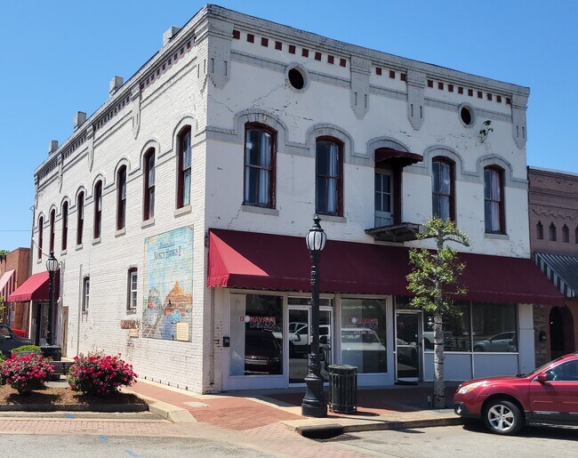
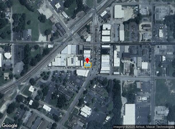
Property Record
215 Main St, Barnesville, GA 30204

NEARBY LISTINGS FOR SALE OR LEASE
-
-
View all Barnesville listings for lease on LoopNet.com
Property Detail
215 Main St
B23-031
BUILDING AND LOT - 215 MAIN ST
Officebuilding
Lamar
X
Georgia
13171C0092C
215
2024
0.06 AC
2025
Lamar County
970300
Atlanta
5,616 SF
Atlanta-Sandy Springs-Roswell, GA
DEMOGRAPHICS near 215 Main St
1 Mile
3 Mile
5 Mile
2024 Total Population
4,499
9,314
13,091
2029 Population
5,230
10,818
15,221
Pop Growth 2024-2029
+ 16.25%
+ 16.15%
+ 16.27%
Average Age
39
39
40
2024 Total Households
1,738
3,554
5,039
HH Growth 2024-2029
+ 17.20%
+ 17.05%
+ 16.95%
Median Household Inc
$41,272
$52,125
$53,974
Avg Household Size
2.40
2.40
2.50
2024 Avg HH Vehicles
2.00
2.00
2.00
Median Home Value
$158,564
$187,026
$193,389
Median Year Built
1973
1975
1979
Nearby Places
Map Layers
Map Styles
 Street
 Aerial
- Restaurants
- Banks
- Shops
- Fitness
- Groceries
SALE & LEASE HISTORY
LISTING DATE
SALE/LEASE

Apr 27, 2023
For Lease
Nearby Properties
Address
Land Use
TOTAL SIZE
Lot Size
Zoning
Address
Land Use
TOTAL SIZE
Lot Size
Zoning
68,664 SF
23.35 AC
024
Address
Land Use
TOTAL SIZE
Lot Size
Zoning
104,598 SF
12.98 AC
002
Address
Land Use
TOTAL SIZE
Lot Size
Zoning
6,975 SF
92.88 AC
003
Address
Land Use
TOTAL SIZE
Lot Size
Zoning
2,886 SF
100 AC
001
Address
Land Use
TOTAL SIZE
Lot Size
Zoning
49.18 AC
I1
Address
Land Use
TOTAL SIZE
Lot Size
Zoning
93,212 SF
36.18 AC
AG
Address
Land Use
TOTAL SIZE
Lot Size
Zoning
130,170 SF
24.50 AC
C-4
Address
Land Use
TOTAL SIZE
Lot Size
Zoning
467,708 SF
79.13 AC
AR
Address
Land Use
TOTAL SIZE
Lot Size
Zoning
11,326 SF
58.66 AC
001
Address
Land Use
TOTAL SIZE
Lot Size
Zoning
22,413 SF
10 AC
C-3
Address
Land Use
TOTAL SIZE
Lot Size
Zoning
144,324 SF
10.67 AC
I-1
Address
Land Use
TOTAL SIZE
Lot Size
Zoning
22,500 SF
10 AC
Address
Land Use
TOTAL SIZE
Lot Size
Zoning
71,104 SF
4.03 AC
R-2
Address
Land Use
TOTAL SIZE
Lot Size
Zoning
28,079 SF
15.61 AC
001
Address
Land Use
TOTAL SIZE
Lot Size
Zoning
32,160 SF
8 AC
R-2
Address
Land Use
TOTAL SIZE
Lot Size
Zoning
20,898 SF
1.67 AC
001
Address
Land Use
TOTAL SIZE
Lot Size
Zoning
24,960 SF
2.52 AC
R-2
Address
Land Use
TOTAL SIZE
Lot Size
Zoning
115,705 SF
29.06 AC
001
Address
Land Use
TOTAL SIZE
Lot Size
Zoning
11,260 SF
4.50 AC
R-2
Address
Land Use
TOTAL SIZE
Lot Size
Zoning
24,590 SF
5.40 AC
R1-B
Address
Land Use
TOTAL SIZE
Lot Size
Zoning
4,108 SF
26.02 AC
001
Address
Land Use
TOTAL SIZE
Lot Size
Zoning
34,506 SF
4.51 AC
C-2
Address
Land Use
TOTAL SIZE
Lot Size
Zoning
13,320 SF
9.51 AC
R2
Address
Land Use
TOTAL SIZE
Lot Size
Zoning
14,859 SF
2.40 AC
C-4
Address
Land Use
TOTAL SIZE
Lot Size
Zoning
13,916 SF
18.43 AC
I-1
Address
Land Use
TOTAL SIZE
Lot Size
Zoning
11,520 SF
1.37 AC
019
Address
Land Use
TOTAL SIZE
Lot Size
Zoning
45,844 SF
6.26 AC
I-1
Address
Land Use
TOTAL SIZE
Lot Size
Zoning
23,040 SF
6.08 AC
R2
Address
Land Use
TOTAL SIZE
Lot Size
Zoning
12,954 SF
0.94 AC
C-2
Address
Land Use
TOTAL SIZE
Lot Size
Zoning
8,810 SF
1.29 AC
002
The World's #1 Commercial Real Estate Marketplace
Connect with us
© 2025 CoStar Group
The information above has been obtained from sources believed reliable. While we do not doubt its accuracy we have not verified it and make no guarantee, warranty or representation about it. It is your responsibility to independently confirm its accuracy and completeness. Any projections, opinions, assumptions, or estimates used are for example only and do not represent the current or future performance of the property. The value of this transaction to you depends on tax and other factors which should be evaluated by your tax, financial, and legal advisors. You and your advisors should conduct a careful, independent investigation of the property to determine to your satisfaction the suitability of the property for your needs.