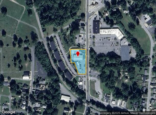
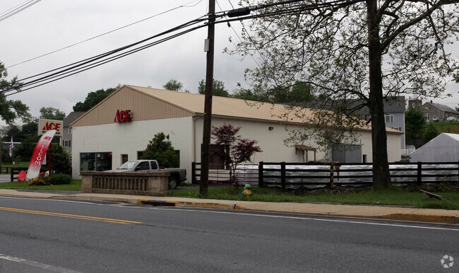
Property Record
215 N Church St, Thurmont, MD 21788

NEARBY LISTINGS FOR SALE OR LEASE
Property Detail
215 N Church St
15-335572
Thurmont
Storebuilding
0.997 ACRES 215 CHURCH ST. THURMONT
AE
Frederick
24021C0043E
Maryland
2024
1 AC
2025
Frederick
753001
Washington, DC
5,000 SF
Washington-Arlington-Alexandria, DC-VA-MD-WV
DEMOGRAPHICS near 215 N Church St
1 Mile
3 Mile
5 Mile
2024 Total Population
4,972
8,747
12,701
2029 Population
5,592
9,856
14,253
Pop Growth 2024-2029
+ 12.47%
+ 12.68%
+ 12.22%
Average Age
41
43
42
2024 Total Households
2,026
3,503
4,659
HH Growth 2024-2029
+ 12.83%
+ 13.07%
+ 13.07%
Median Household Inc
$75,741
$79,300
$78,717
Avg Household Size
2.40
2.50
2.50
2024 Avg HH Vehicles
2.00
2.00
2.00
Median Home Value
$313,986
$311,441
$329,597
Median Year Built
1976
1977
1975
Nearby Places
Map Layers
Map Styles
 Street
 Aerial
- Restaurants
- Banks
- Shops
- Fitness
- Groceries
PUBLIC TRANSPORTATION
AIRPORT
Hagerstown Regional/Richard A Henson Field
DRIVE
WALK
Distance
Hagerstown Regional/Richard A Henson Field
47 min
23.2 mi
Freight Ports
Port of Baltimore
DRIVE
WALK
Distance
Port of Baltimore
83 min
62.1 mi
Nearby Properties
Address
Land Use
TOTAL SIZE
Lot Size
Zoning
Address
Land Use
TOTAL SIZE
Lot Size
Zoning
204,749 SF
41.79 AC
R1
Address
Land Use
TOTAL SIZE
Lot Size
Zoning
2,560 SF
5 AC
RC
Address
Land Use
TOTAL SIZE
Lot Size
Zoning
67,069 SF
13.47 AC
R3
Address
Land Use
TOTAL SIZE
Lot Size
Zoning
141,864 SF
7.06 AC
INST
Address
Land Use
TOTAL SIZE
Lot Size
Zoning
21,971 SF
100 AC
RC
Address
Land Use
TOTAL SIZE
Lot Size
Zoning
226,655 SF
22.10 AC
I
Address
Land Use
TOTAL SIZE
Lot Size
Zoning
38,514 SF
10 AC
R2
Address
Land Use
TOTAL SIZE
Lot Size
Zoning
25,088 SF
4.17 AC
INST
Address
Land Use
TOTAL SIZE
Lot Size
Zoning
112,962 SF
45.80 AC
LI
Address
Land Use
TOTAL SIZE
Lot Size
Zoning
59,148 SF
6.55 AC
GB
Address
Land Use
TOTAL SIZE
Lot Size
Zoning
54,070 SF
12.52 AC
GB
Address
Land Use
TOTAL SIZE
Lot Size
Zoning
27,104 SF
5.97 AC
GB
Address
Land Use
TOTAL SIZE
Lot Size
Zoning
164,156 SF
5.13 AC
I
Address
Land Use
TOTAL SIZE
Lot Size
Zoning
158,120 SF
50.17 AC
I
Address
Land Use
TOTAL SIZE
Lot Size
Zoning
45,960 SF
4.07 AC
R5
Address
Land Use
TOTAL SIZE
Lot Size
Zoning
12,111 SF
13.64 AC
R2
Address
Land Use
TOTAL SIZE
Lot Size
Zoning
23,574 SF
2.90 AC
GB
Address
Land Use
TOTAL SIZE
Lot Size
Zoning
65,374 SF
11.43 AC
I
Address
Land Use
TOTAL SIZE
Lot Size
Zoning
34,095 SF
3.14 AC
GB
Address
Land Use
TOTAL SIZE
Lot Size
Zoning
28,548 SF
21.50 AC
A
Address
Land Use
TOTAL SIZE
Lot Size
Zoning
18,542 SF
3.28 AC
GB
Address
Land Use
TOTAL SIZE
Lot Size
Zoning
15,000 SF
2.94 AC
GB
Address
Land Use
TOTAL SIZE
Lot Size
Zoning
15,100 SF
0.96 AC
TB
Address
Land Use
TOTAL SIZE
Lot Size
Zoning
17,784 SF
2.36 AC
GB
Address
Land Use
TOTAL SIZE
Lot Size
Zoning
17,300 SF
4.28 AC
R1
Address
Land Use
TOTAL SIZE
Lot Size
Zoning
3,117 SF
0.59 AC
GB
Address
Land Use
TOTAL SIZE
Lot Size
Zoning
6,831 SF
0.76 AC
GB
Address
Land Use
TOTAL SIZE
Lot Size
Zoning
13,200 SF
1.43 AC
GB
Address
Land Use
TOTAL SIZE
Lot Size
Zoning
19,163 SF
1.39 AC
TB
Address
Land Use
TOTAL SIZE
Lot Size
Zoning
12,388 SF
2.92 AC
I
The World's #1 Commercial Real Estate Marketplace
Connect with us
© 2025 CoStar Group
The information above has been obtained from sources believed reliable. While we do not doubt its accuracy we have not verified it and make no guarantee, warranty or representation about it. It is your responsibility to independently confirm its accuracy and completeness. Any projections, opinions, assumptions, or estimates used are for example only and do not represent the current or future performance of the property. The value of this transaction to you depends on tax and other factors which should be evaluated by your tax, financial, and legal advisors. You and your advisors should conduct a careful, independent investigation of the property to determine to your satisfaction the suitability of the property for your needs.