Property Record
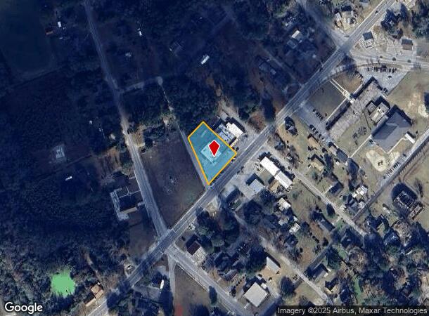
215 N Jones Rd, Olanta, SC 29114
NEARBY LISTINGS FOR SALE OR LEASE
-
-
View all Olanta listings for sale on LoopNet.com
Property Detail
215 N Jones Rd
Supermarket
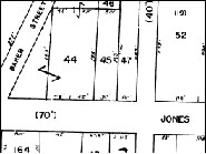
JONES ST & BAKER ST L A
X
Florence
45027C0050C
South Carolina
2024
0.71 AC
2024
Other Market Areas
002400
Florence, SC
9,020 SF
04520-03-044
DEMOGRAPHICS near 215 N Jones Rd
1 Mile
3 Mile
5 Mile
2024 Total Population
474
1,208
3,076
2029 Population
449
1,147
2,923
Pop Growth 2024-2029
(5.27%)
(5.05%)
(4.97%)
Average Age
41
41
41
2024 Total Households
191
480
1,207
HH Growth 2024-2029
(4.71%)
(5.00%)
(4.97%)
Median Household Inc
$52,000
$45,536
$55,781
Avg Household Size
2.50
2.50
2.50
2024 Avg HH Vehicles
2.00
2.00
2.00
Median Home Value
$77,319
$77,235
$88,888
Median Year Built
1975
1976
1977
Nearby Places
Map Layers
Map Styles
 Street
 Aerial
- Restaurants
- Banks
- Shops
- Fitness
- Groceries
Nearby Properties
Address
Land Use
TOTAL SIZE
Lot Size
Zoning
Address
Land Use
TOTAL SIZE
Lot Size
Zoning
1,485 SF
1.04 AC
Address
Land Use
TOTAL SIZE
Lot Size
Zoning
2,653 SF
1.05 AC
Address
Land Use
TOTAL SIZE
Lot Size
Zoning
42,745 SF
6.06 AC
R4
Address
Land Use
TOTAL SIZE
Lot Size
Zoning
9,100 SF
2.11 AC
Address
Land Use
TOTAL SIZE
Lot Size
Zoning
7,151 SF
0.43 AC
B3
Address
Land Use
TOTAL SIZE
Lot Size
Zoning
1,458 SF
298.97 AC
Address
Land Use
TOTAL SIZE
Lot Size
Zoning
10,920 SF
1.45 AC
Address
Land Use
TOTAL SIZE
Lot Size
Zoning
317 AC
Address
Land Use
TOTAL SIZE
Lot Size
Zoning
62,829 SF
15 AC
Address
Land Use
TOTAL SIZE
Lot Size
Zoning
80.49 AC
Address
Land Use
TOTAL SIZE
Lot Size
Zoning
6,640 SF
1.05 AC
B3
Address
Land Use
TOTAL SIZE
Lot Size
Zoning
Address
Land Use
TOTAL SIZE
Lot Size
Zoning
153.11 AC
Address
Land Use
TOTAL SIZE
Lot Size
Zoning
1,200 SF
0.18 AC
B3
Address
Land Use
TOTAL SIZE
Lot Size
Zoning
2,500 SF
177.14 AC
Address
Land Use
TOTAL SIZE
Lot Size
Zoning
Address
Land Use
TOTAL SIZE
Lot Size
Zoning
4,350 SF
0.75 AC
B3
Address
Land Use
TOTAL SIZE
Lot Size
Zoning
150.80 AC
Address
Land Use
TOTAL SIZE
Lot Size
Zoning
942 SF
125 AC
Address
Land Use
TOTAL SIZE
Lot Size
Zoning
140 AC
Address
Land Use
TOTAL SIZE
Lot Size
Zoning
129 AC
Address
Land Use
TOTAL SIZE
Lot Size
Zoning
130.75 AC
Address
Land Use
TOTAL SIZE
Lot Size
Zoning
126 AC
Address
Land Use
TOTAL SIZE
Lot Size
Zoning
1,341 SF
110 AC
Address
Land Use
TOTAL SIZE
Lot Size
Zoning
117.70 AC
Address
Land Use
TOTAL SIZE
Lot Size
Zoning
117.01 AC
Address
Land Use
TOTAL SIZE
Lot Size
Zoning
Address
Land Use
TOTAL SIZE
Lot Size
Zoning
Address
Land Use
TOTAL SIZE
Lot Size
Zoning
4,904 SF
98.53 AC
The World's #1 Commercial Real Estate Marketplace
Connect with us
© 2026 CoStar Group
The information above has been obtained from sources believed reliable. While we do not doubt its accuracy we have not verified it and make no guarantee, warranty or representation about it. It is your responsibility to independently confirm its accuracy and completeness. Any projections, opinions, assumptions, or estimates used are for example only and do not represent the current or future performance of the property. The value of this transaction to you depends on tax and other factors which should be evaluated by your tax, financial, and legal advisors. You and your advisors should conduct a careful, independent investigation of the property to determine to your satisfaction the suitability of the property for your needs.