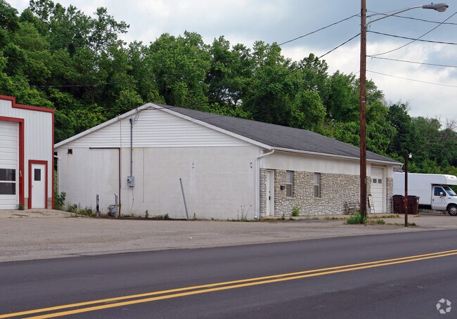
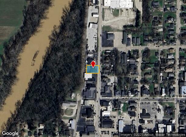
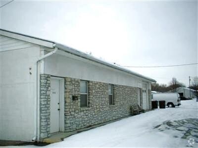
Property Record
215 N State St, West Harrison, IN 47060
NEARBY LISTINGS FOR SALE OR LEASE
Property Detail
215 N State St
15-01-13-404-006.001-007
S13t7nr1w
Commercialnec
01-12 W HARRISON 13-7-1 0.2293A PER SURVEY TRACT 1 (9, 989.33 SQ FT)
AE
Dearborn
18029C0064C
Indiana
2024
0.23 AC
2024
Dearborn County
080204
Cincinnati/Dayton
2,242 SF
Cincinnati, OH-KY-IN
DEMOGRAPHICS near 215 N State St
1 Mile
3 Mile
5 Mile
2024 Total Population
4,145
14,595
29,023
2029 Population
4,099
14,457
29,029
Pop Growth 2024-2029
(1.11%)
(0.95%)
+ 0.02%
Average Age
39
41
41
2024 Total Households
1,726
5,821
11,135
HH Growth 2024-2029
(1.10%)
(1.01%)
(0.13%)
Median Household Inc
$60,300
$77,273
$87,055
Avg Household Size
2.40
2.50
2.60
2024 Avg HH Vehicles
2.00
2.00
2.00
Median Home Value
$151,387
$187,883
$226,234
Median Year Built
1965
1984
1988
Nearby Places
Map Layers
Map Styles
 Street
 Aerial
- Restaurants
- Banks
- Shops
- Fitness
- Groceries
PUBLIC TRANSPORTATION
AIRPORT
Cincinnati/Northern Kentucky International
DRIVE
WALK
Distance
Cincinnati/Northern Kentucky International
46 min
30.6 mi
Nearby Properties
Address
Land Use
TOTAL SIZE
Lot Size
Zoning
Address
Land Use
TOTAL SIZE
Lot Size
Zoning
102.29 AC
Address
Land Use
TOTAL SIZE
Lot Size
Zoning
35.80 AC
Address
Land Use
TOTAL SIZE
Lot Size
Zoning
2,040 SF
27.24 AC
Address
Land Use
TOTAL SIZE
Lot Size
Zoning
85,849 SF
14.25 AC
Address
Land Use
TOTAL SIZE
Lot Size
Zoning
22.19 AC
Address
Land Use
TOTAL SIZE
Lot Size
Zoning
8.43 AC
Address
Land Use
TOTAL SIZE
Lot Size
Zoning
Address
Land Use
TOTAL SIZE
Lot Size
Zoning
27,234 SF
12.68 AC
Address
Land Use
TOTAL SIZE
Lot Size
Zoning
19.13 AC
Address
Land Use
TOTAL SIZE
Lot Size
Zoning
61.50 AC
H
Address
Land Use
TOTAL SIZE
Lot Size
Zoning
11.90 AC
Address
Land Use
TOTAL SIZE
Lot Size
Zoning
7.86 AC
Address
Land Use
TOTAL SIZE
Lot Size
Zoning
12.34 AC
Address
Land Use
TOTAL SIZE
Lot Size
Zoning
Address
Land Use
TOTAL SIZE
Lot Size
Zoning
5,320 SF
26.52 AC
Address
Land Use
TOTAL SIZE
Lot Size
Zoning
27,586 SF
8 AC
Address
Land Use
TOTAL SIZE
Lot Size
Zoning
49,011 SF
11.22 AC
H
Address
Land Use
TOTAL SIZE
Lot Size
Zoning
19.28 AC
Address
Land Use
TOTAL SIZE
Lot Size
Zoning
43,445 SF
6 AC
Address
Land Use
TOTAL SIZE
Lot Size
Zoning
14.95 AC
Address
Land Use
TOTAL SIZE
Lot Size
Zoning
7.48 AC
Address
Land Use
TOTAL SIZE
Lot Size
Zoning
12,120 SF
7.47 AC
Address
Land Use
TOTAL SIZE
Lot Size
Zoning
Address
Land Use
TOTAL SIZE
Lot Size
Zoning
25.54 AC
A
Address
Land Use
TOTAL SIZE
Lot Size
Zoning
5.32 AC
D
Address
Land Use
TOTAL SIZE
Lot Size
Zoning
35,000 SF
14.90 AC
Address
Land Use
TOTAL SIZE
Lot Size
Zoning
12,120 SF
4.01 AC
Address
Land Use
TOTAL SIZE
Lot Size
Zoning
14.68 AC
Address
Land Use
TOTAL SIZE
Lot Size
Zoning
3.78 AC
D
Address
Land Use
TOTAL SIZE
Lot Size
Zoning
7.12 AC
The World's #1 Commercial Real Estate Marketplace
Connect with us
© 2025 CoStar Group
The information above has been obtained from sources believed reliable. While we do not doubt its accuracy we have not verified it and make no guarantee, warranty or representation about it. It is your responsibility to independently confirm its accuracy and completeness. Any projections, opinions, assumptions, or estimates used are for example only and do not represent the current or future performance of the property. The value of this transaction to you depends on tax and other factors which should be evaluated by your tax, financial, and legal advisors. You and your advisors should conduct a careful, independent investigation of the property to determine to your satisfaction the suitability of the property for your needs.