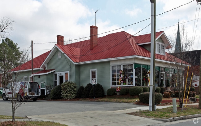
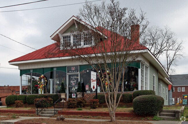
Property Record
215 S 3Rd St, Smithfield, NC 27577

Property Detail
215 S 3Rd St
15025028
74/124 169418-73
Religious
JOHNSTON
OFF
North Carolina
B and X Area of moderate flood hazard, usually the area between the limits of the 100-year and 500-year floods.
1.46 AC
0
Johnston County
2025
Raleigh/Durham
040800
Raleigh-Cary, NC
12,752 SF
NEARBY LISTINGS FOR SALE OR LEASE
DEMOGRAPHICS near 215 S 3Rd St
1 mile
3 mile
5 mile
2024 Total Population
5,459
15,148
30,749
2029 Population
6,134
17,020
34,488
Pop Growth 2024-2029
+ 12.36%
+ 12.36%
+ 12.16%
Average Age
41
42
40
2024 Total Households
2,151
5,990
11,572
HH Growth 2024-2029
+ 12.60%
+ 12.57%
+ 12.35%
Median Household Inc
$34,309
$44,904
$50,392
Avg Household Size
2.40
2.40
2.50
2024 Avg HH Vehicles
2.00
2.00
2.00
Median Home Value
$274,586
$237,312
$242,687
Median Year Built
1970
1976
1982
Nearby Places
Map Layers
Map Styles
 Street
 Aerial
Transit
 Traffic
 Biking
Places
Listings with unknown addresses are not visible on the map
- Restaurants
- Banks
- Shops
- Fitness
- Groceries
PUBLIC TRANSPORTATION
COMMUTER RAIL
Drive
Walk
Distance
11 min
6.2 mi
AIRPORT
Raleigh-Durham International
Drive
Walk
Distance
Raleigh-Durham International
59 min
44.2 mi
Nearby Properties
Address
Land Use
TOTAL SIZE
Lot Size
Zoning
Address
Land Use
TOTAL SIZE
Lot Size
Zoning
581,400 SF
169.67 AC
IND
Address
Land Use
TOTAL SIZE
Lot Size
Zoning
59,114 SF
100.50 AC
OFF
Address
Land Use
TOTAL SIZE
Lot Size
Zoning
202,660 SF
90.41 AC
IND
Address
Land Use
TOTAL SIZE
Lot Size
Zoning
16.84 AC
OFF
Address
Land Use
TOTAL SIZE
Lot Size
Zoning
118,710 SF
34.77 AC
OFF
Address
Land Use
TOTAL SIZE
Lot Size
Zoning
158,778 SF
35.88 AC
OFF
Address
Land Use
TOTAL SIZE
Lot Size
Zoning
85,041 SF
35.02 AC
SUP
Address
Land Use
TOTAL SIZE
Lot Size
Zoning
264,880 SF
19.07 AC
IND
Address
Land Use
TOTAL SIZE
Lot Size
Zoning
71,860 SF
1.28 AC
OFF
Address
Land Use
TOTAL SIZE
Lot Size
Zoning
697,252 SF
114.71 AC
IND
Address
Land Use
TOTAL SIZE
Lot Size
Zoning
249,045 SF
27.03 AC
IND
Address
Land Use
TOTAL SIZE
Lot Size
Zoning
95,952 SF
0.34 AC
OFF
Address
Land Use
TOTAL SIZE
Lot Size
Zoning
197,722 SF
25.55 AC
COM
Address
Land Use
TOTAL SIZE
Lot Size
Zoning
79,034 SF
30 AC
OFF
Address
Land Use
TOTAL SIZE
Lot Size
Zoning
57,014 SF
15.03 AC
COM
Address
Land Use
TOTAL SIZE
Lot Size
Zoning
75,657 SF
15.30 AC
OFF
Address
Land Use
TOTAL SIZE
Lot Size
Zoning
24,830 SF
28.89 AC
OFF
Address
Land Use
TOTAL SIZE
Lot Size
Zoning
39,191 SF
7.46 AC
COM
Address
Land Use
TOTAL SIZE
Lot Size
Zoning
72,165 SF
24.21 AC
COM
Address
Land Use
TOTAL SIZE
Lot Size
Zoning
78,588 SF
7.99 AC
SUP
Address
Land Use
TOTAL SIZE
Lot Size
Zoning
41,545 SF
4.86 AC
OFF
Address
Land Use
TOTAL SIZE
Lot Size
Zoning
64,134 SF
3.03 AC
COM
Address
Land Use
TOTAL SIZE
Lot Size
Zoning
120,872 SF
13.57 AC
COM
Address
Land Use
TOTAL SIZE
Lot Size
Zoning
26,980 SF
42.14 AC
OFF
Address
Land Use
TOTAL SIZE
Lot Size
Zoning
42,806 SF
1.99 AC
COM
Address
Land Use
TOTAL SIZE
Lot Size
Zoning
112,276 SF
10.57 AC
COM
Address
Land Use
TOTAL SIZE
Lot Size
Zoning
31,195 SF
10 AC
OFF
Address
Land Use
TOTAL SIZE
Lot Size
Zoning
50,350 SF
2.05 AC
COM
Address
Land Use
TOTAL SIZE
Lot Size
Zoning
15,120 SF
0.89 AC
COM
Address
Land Use
TOTAL SIZE
Lot Size
Zoning
2,065 SF
24.99 AC
COM
The World's #1 Commercial Real Estate Marketplace
Connect with us
© 2026 CoStar Group
The information above has been obtained from sources believed reliable. While we do not doubt its accuracy we have not verified it and make no guarantee, warranty or representation about it. It is your responsibility to independently confirm its accuracy and completeness. Any projections, opinions, assumptions, or estimates used are for example only and do not represent the current or future performance of the property. The value of this transaction to you depends on tax and other factors which should be evaluated by your tax, financial, and legal advisors. You and your advisors should conduct a careful, independent investigation of the property to determine to your satisfaction the suitability of the property for your needs.