Property Record
215 S Complex Dr, Kalispell, MT 59901
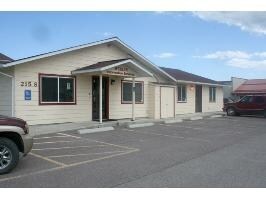

Property Detail
215 S Complex Dr
Kalispell, MT
KAL INDUSTRIAL CENTER UNIT 1, S10, T27 N, R21 W, LOT 12, ASSR# 0000980056
07-3834-10-1-02-35-0000
Flathead
Officebuilding
Montana
B and X Area of moderate flood hazard, usually the area between the limits of the 100-year and 500-year floods.
12
2025
1.22 AC
2025
Glacier Country
001401
Other Market Areas
10,200 SF
NEARBY LISTINGS FOR SALE OR LEASE
-
-
View all Kalispell listings for lease on LoopNet.com
DEMOGRAPHICS near 215 S Complex Dr
1 mile
3 mile
5 mile
2025 Total Population
324
2,418
9,357
2030 Population
330
2,479
9,814
Pop Growth 2025-2030
+ 1.85%
+ 2.52%
+ 4.88%
Average Age
41
41
40
2025 Total Households
123
909
3,537
HH Growth 2025-2030
+ 1.63%
+ 2.42%
+ 4.81%
Median Household Inc
$59,838
$66,368
$81,177
Avg Household Size
2.50
2.60
2.50
2025 Avg HH Vehicles
2.00
3.00
2.00
Median Home Value
$742,647
$724,849
$562,080
Median Year Built
1990
1991
1992
Nearby Places
Map Layers
Map Styles
 Street
 Aerial
Layers
 Traffic
 Biking
Places
Listings with unknown addresses are not visible on the map
- Restaurants
- Banks
- Shops
- Fitness
- Groceries
PUBLIC TRANSPORTATION
AIRPORT
Glacier Park International
Drive
Walk
Distance
Glacier Park International
25 min
15.6 mi
Freight Ports
Port of Everett
Drive
Walk
Distance
Port of Everett
627 min
532.7 mi
SALE & LEASE HISTORY
LISTING DATE
SALE/LEASE

Sep 05, 2021
For Lease
Nearby Properties
Address
Land Use
TOTAL SIZE
Lot Size
Zoning
Address
Land Use
TOTAL SIZE
Lot Size
Zoning
90,186 SF
10.60 AC
Address
Land Use
TOTAL SIZE
Lot Size
Zoning
4,536 SF
11.86 AC
Address
Land Use
TOTAL SIZE
Lot Size
Zoning
48,678 SF
5.86 AC
Address
Land Use
TOTAL SIZE
Lot Size
Zoning
101,080 SF
6.52 AC
1
Address
Land Use
TOTAL SIZE
Lot Size
Zoning
18,500 SF
11.66 AC
Address
Land Use
TOTAL SIZE
Lot Size
Zoning
21,598 SF
9.27 AC
Address
Land Use
TOTAL SIZE
Lot Size
Zoning
14,920 SF
14.59 AC
Address
Land Use
TOTAL SIZE
Lot Size
Zoning
32,744 SF
3.11 AC
Address
Land Use
TOTAL SIZE
Lot Size
Zoning
6,400 SF
10.88 AC
Address
Land Use
TOTAL SIZE
Lot Size
Zoning
12,910 SF
1.61 AC
Address
Land Use
TOTAL SIZE
Lot Size
Zoning
6,000 SF
7.07 AC
Address
Land Use
TOTAL SIZE
Lot Size
Zoning
7,412 SF
9.75 AC
1-1H LIGHT
Address
Land Use
TOTAL SIZE
Lot Size
Zoning
9,731 SF
5.30 AC
Address
Land Use
TOTAL SIZE
Lot Size
Zoning
12,000 SF
5 AC
Address
Land Use
TOTAL SIZE
Lot Size
Zoning
8,064 SF
25.80 AC
Address
Land Use
TOTAL SIZE
Lot Size
Zoning
600 SF
3.15 AC
1
Address
Land Use
TOTAL SIZE
Lot Size
Zoning
25,270 SF
5.08 AC
Address
Land Use
TOTAL SIZE
Lot Size
Zoning
12,500 SF
6.94 AC
Address
Land Use
TOTAL SIZE
Lot Size
Zoning
4,600 SF
2.23 AC
Address
Land Use
TOTAL SIZE
Lot Size
Zoning
25.78 AC
Address
Land Use
TOTAL SIZE
Lot Size
Zoning
23,810 SF
8.17 AC
Address
Land Use
TOTAL SIZE
Lot Size
Zoning
18,900 SF
5.16 AC
Address
Land Use
TOTAL SIZE
Lot Size
Zoning
6,618 SF
19.18 AC
Address
Land Use
TOTAL SIZE
Lot Size
Zoning
20,300 SF
9.09 AC
Address
Land Use
TOTAL SIZE
Lot Size
Zoning
13,000 SF
9.46 AC
1
Address
Land Use
TOTAL SIZE
Lot Size
Zoning
11,780 SF
10.25 AC
Address
Land Use
TOTAL SIZE
Lot Size
Zoning
14,312 SF
7.22 AC
Address
Land Use
TOTAL SIZE
Lot Size
Zoning
16,500 SF
4 AC
1
Address
Land Use
TOTAL SIZE
Lot Size
Zoning
14,728 SF
1.57 AC
Address
Land Use
TOTAL SIZE
Lot Size
Zoning
7,500 SF
4.99 AC
The World's #1 Commercial Real Estate Marketplace
Connect with us
© 2026 CoStar Group
The information above has been obtained from sources believed reliable. While we do not doubt its accuracy we have not verified it and make no guarantee, warranty or representation about it. It is your responsibility to independently confirm its accuracy and completeness. Any projections, opinions, assumptions, or estimates used are for example only and do not represent the current or future performance of the property. The value of this transaction to you depends on tax and other factors which should be evaluated by your tax, financial, and legal advisors. You and your advisors should conduct a careful, independent investigation of the property to determine to your satisfaction the suitability of the property for your needs.