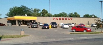
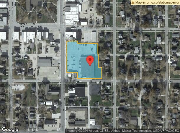
Property Record
215 S Main St, Osceola, IA 50213
NEARBY LISTINGS FOR SALE OR LEASE
-
-
View all Osceola listings for sale on LoopNet.com
Property Detail
215 S Main St
12374
Osc-Original
Supermarket
ORIGINAL OSCEOLAA TRACT OF LAND IN LOTS 3 4 5 6 7 8 & 9AND ALLEYS INBETWEEN BLOCK 17
X
Clarke
19039C0192B
Iowa
2024
3-9
2025
2.38 AC
960100
Iowa West Area
24,278 SF
Other Market Areas
DEMOGRAPHICS near 215 S Main St
1 Mile
3 Mile
5 Mile
2024 Total Population
4,844
5,787
6,302
2029 Population
4,809
5,745
6,250
Pop Growth 2024-2029
(0.72%)
(0.73%)
(0.83%)
Average Age
39
40
40
2024 Total Households
1,934
2,299
2,499
HH Growth 2024-2029
(0.72%)
(0.70%)
(0.80%)
Median Household Inc
$55,477
$53,673
$55,032
Avg Household Size
2.50
2.50
2.50
2024 Avg HH Vehicles
2.00
2.00
2.00
Median Home Value
$117,586
$127,374
$135,034
Median Year Built
1972
1973
1973
Nearby Places
Map Layers
Map Styles
 Street
 Aerial
- Restaurants
- Banks
- Shops
- Fitness
- Groceries
PUBLIC TRANSPORTATION
COMMUTER RAIL
DRIVE
WALK
Distance
1 min
8 min
0.4 mi
AIRPORT
Des Moines International
DRIVE
WALK
Distance
Des Moines International
55 min
43.4 mi
Nearby Properties
Address
Land Use
TOTAL SIZE
Lot Size
Zoning
Address
Land Use
TOTAL SIZE
Lot Size
Zoning
27,744 SF
60.24 AC
Address
Land Use
TOTAL SIZE
Lot Size
Zoning
3,100 SF
95.01 AC
Address
Land Use
TOTAL SIZE
Lot Size
Zoning
1,800 SF
14 AC
Address
Land Use
TOTAL SIZE
Lot Size
Zoning
65,186 SF
5.88 AC
Address
Land Use
TOTAL SIZE
Lot Size
Zoning
99,596 SF
18.13 AC
Address
Land Use
TOTAL SIZE
Lot Size
Zoning
34,738 SF
6.97 AC
Address
Land Use
TOTAL SIZE
Lot Size
Zoning
864 SF
24.73 AC
Address
Land Use
TOTAL SIZE
Lot Size
Zoning
29,900 SF
5.34 AC
Address
Land Use
TOTAL SIZE
Lot Size
Zoning
6,801 SF
1.74 AC
Address
Land Use
TOTAL SIZE
Lot Size
Zoning
212,800 SF
51.07 AC
Address
Land Use
TOTAL SIZE
Lot Size
Zoning
15,923 SF
3.33 AC
Address
Land Use
TOTAL SIZE
Lot Size
Zoning
35,499 SF
6.17 AC
Address
Land Use
TOTAL SIZE
Lot Size
Zoning
13,316 SF
3 AC
Address
Land Use
TOTAL SIZE
Lot Size
Zoning
46,646 SF
12 AC
Address
Land Use
TOTAL SIZE
Lot Size
Zoning
795 SF
4.17 AC
Address
Land Use
TOTAL SIZE
Lot Size
Zoning
25,979 SF
Address
Land Use
TOTAL SIZE
Lot Size
Zoning
4,225 SF
2.07 AC
Address
Land Use
TOTAL SIZE
Lot Size
Zoning
88,224 SF
25.93 AC
Address
Land Use
TOTAL SIZE
Lot Size
Zoning
6,966 SF
6.22 AC
Address
Land Use
TOTAL SIZE
Lot Size
Zoning
8,237 SF
4 AC
Address
Land Use
TOTAL SIZE
Lot Size
Zoning
9,707 SF
0.39 AC
Address
Land Use
TOTAL SIZE
Lot Size
Zoning
34,600 SF
11.34 AC
Address
Land Use
TOTAL SIZE
Lot Size
Zoning
22,293 SF
1.45 AC
Address
Land Use
TOTAL SIZE
Lot Size
Zoning
4,348 SF
1.02 AC
Address
Land Use
TOTAL SIZE
Lot Size
Zoning
5,760 SF
11.86 AC
Address
Land Use
TOTAL SIZE
Lot Size
Zoning
1,646 SF
1.75 AC
Address
Land Use
TOTAL SIZE
Lot Size
Zoning
10,920 SF
4.57 AC
Address
Land Use
TOTAL SIZE
Lot Size
Zoning
10,363 SF
1.14 AC
Address
Land Use
TOTAL SIZE
Lot Size
Zoning
13,882 SF
3.25 AC
The World's #1 Commercial Real Estate Marketplace
Connect with us
© 2026 CoStar Group
The information above has been obtained from sources believed reliable. While we do not doubt its accuracy we have not verified it and make no guarantee, warranty or representation about it. It is your responsibility to independently confirm its accuracy and completeness. Any projections, opinions, assumptions, or estimates used are for example only and do not represent the current or future performance of the property. The value of this transaction to you depends on tax and other factors which should be evaluated by your tax, financial, and legal advisors. You and your advisors should conduct a careful, independent investigation of the property to determine to your satisfaction the suitability of the property for your needs.