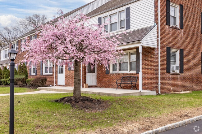
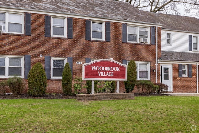
Property Record
215 S Park Dr, Woodbridge, NJ 07095
NEARBY LISTINGS FOR SALE OR LEASE
Property Detail
215 S Park Dr
New York-Jersey City-White Plains, NY-NJ
Incl
25-00282-0000-00002
3.6540
Apartment
Middlesex
X
New Jersey
34023C0066F
2
2024
3.65 AC
2025
Downtown Woodbridge
003001
Northern New Jersey
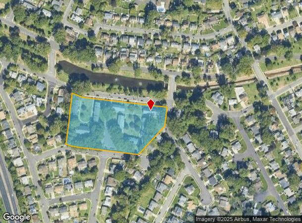
DEMOGRAPHICS near 215 S Park Dr
1 Mile
3 Mile
5 Mile
2024 Total Population
18,346
138,394
342,334
2029 Population
18,343
136,859
337,828
Pop Growth 2024-2029
(0.02%)
(1.11%)
(1.32%)
Average Age
40
39
40
2024 Total Households
7,018
47,796
119,591
HH Growth 2024-2029
(0.19%)
(1.14%)
(1.35%)
Median Household Inc
$94,822
$89,808
$96,007
Avg Household Size
2.50
2.80
2.80
2024 Avg HH Vehicles
2.00
2.00
2.00
Median Home Value
$334,420
$349,818
$422,398
Median Year Built
1971
1961
1967
Nearby Places
Map Layers
Map Styles
 Street
 Aerial
- Restaurants
- Banks
- Shops
- Fitness
- Groceries
PUBLIC TRANSPORTATION
COMMUTER RAIL
Woodbridge (North Jersey Coast Line - NJ Transit Commuter Rail (NJ Transit))
DRIVE
WALK
Distance
Woodbridge (North Jersey Coast Line - NJ Transit Commuter Rail (NJ Transit))
2 min
14 min
0.7 mi
Avenel (North Jersey Coast Line - NJ Transit Commuter Rail (NJ Transit))
DRIVE
WALK
Distance
Avenel (North Jersey Coast Line - NJ Transit Commuter Rail (NJ Transit))
5 min
2.7 mi
AIRPORT
Newark Liberty International
DRIVE
WALK
Distance
Newark Liberty International
26 min
15.7 mi
LaGuardia
DRIVE
WALK
Distance
LaGuardia
58 min
36.2 mi
John F Kennedy International
DRIVE
WALK
Distance
John F Kennedy International
57 min
38.9 mi
Freight Ports
New York Container Terminal
DRIVE
WALK
Distance
New York Container Terminal
18 min
11.5 mi
Nearby Properties
Address
Land Use
TOTAL SIZE
Lot Size
Zoning
Address
Land Use
TOTAL SIZE
Lot Size
Zoning
65.84 AC
PB
Address
Land Use
TOTAL SIZE
Lot Size
Zoning
329,350 SF
15.99 AC
Address
Land Use
TOTAL SIZE
Lot Size
Zoning
37.32 AC
S-3B
Address
Land Use
TOTAL SIZE
Lot Size
Zoning
298,080 SF
13.79 AC
LI
Address
Land Use
TOTAL SIZE
Lot Size
Zoning
10,240 SF
22.96 AC
LI
Address
Land Use
TOTAL SIZE
Lot Size
Zoning
Address
Land Use
TOTAL SIZE
Lot Size
Zoning
11.63 AC
S-3D
Address
Land Use
TOTAL SIZE
Lot Size
Zoning
80,000 SF
23.37 AC
R50
Address
Land Use
TOTAL SIZE
Lot Size
Zoning
0.14 AC
C-4
Address
Land Use
TOTAL SIZE
Lot Size
Zoning
10.69 AC
R-MM
Address
Land Use
TOTAL SIZE
Lot Size
Zoning
15.15 AC
RMMF
Address
Land Use
TOTAL SIZE
Lot Size
Zoning
71.66 AC
M-3
Address
Land Use
TOTAL SIZE
Lot Size
Zoning
2.51 AC
H
Address
Land Use
TOTAL SIZE
Lot Size
Zoning
28.90 AC
S-3B
Address
Land Use
TOTAL SIZE
Lot Size
Zoning
52.97 AC
M-3
Address
Land Use
TOTAL SIZE
Lot Size
Zoning
231,654 SF
10.94 AC
LI
Address
Land Use
TOTAL SIZE
Lot Size
Zoning
64.66 AC
S-3A
Address
Land Use
TOTAL SIZE
Lot Size
Zoning
9.90 AC
LI
Address
Land Use
TOTAL SIZE
Lot Size
Zoning
38,900 SF
10.34 AC
LI
Address
Land Use
TOTAL SIZE
Lot Size
Zoning
0.66 AC
C-4
Address
Land Use
TOTAL SIZE
Lot Size
Zoning
6.79 AC
R-50
Address
Land Use
TOTAL SIZE
Lot Size
Zoning
112,820 SF
5.29 AC
LI
Address
Land Use
TOTAL SIZE
Lot Size
Zoning
191.81 AC
R75
Address
Land Use
TOTAL SIZE
Lot Size
Zoning
6,822 SF
29.22 AC
S-2C
Address
Land Use
TOTAL SIZE
Lot Size
Zoning
65.20 AC
Address
Land Use
TOTAL SIZE
Lot Size
Zoning
Address
Land Use
TOTAL SIZE
Lot Size
Zoning
91,086 SF
5.73 AC
LI
Address
Land Use
TOTAL SIZE
Lot Size
Zoning
39.14 AC
M-3
Address
Land Use
TOTAL SIZE
Lot Size
Zoning
176.42 AC
Address
Land Use
TOTAL SIZE
Lot Size
Zoning
35.05 AC
M-3
The World's #1 Commercial Real Estate Marketplace
Connect with us
© 2025 CoStar Group
The information above has been obtained from sources believed reliable. While we do not doubt its accuracy we have not verified it and make no guarantee, warranty or representation about it. It is your responsibility to independently confirm its accuracy and completeness. Any projections, opinions, assumptions, or estimates used are for example only and do not represent the current or future performance of the property. The value of this transaction to you depends on tax and other factors which should be evaluated by your tax, financial, and legal advisors. You and your advisors should conduct a careful, independent investigation of the property to determine to your satisfaction the suitability of the property for your needs.