Property Record
215 Se Interstate Dr, Lawton, OK 73501


Save to a Folder
{{folder.Name}}
{{folder.ListingIds.length}} Properties
{{folder.ListingIds.length}} Property
Create a New Folder
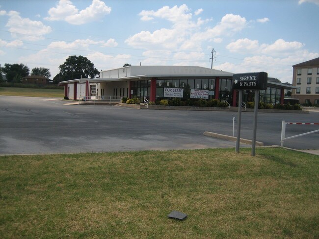
Property Detail
215 Se Interstate Dr
Lawton, OK
32-2N-11W C T BEG NW/C NW/4 NE/4; THN E 70' S 60' THN S'RLY ON A CURVE TO THE LEFT HAV A RAD=672.96' 377.16' (S31*54'11'E) 22
0022939
Comanche
Vehiclerentalsvehiclesales
Oklahoma
C and X Area of minimal flood hazard, usually depicted on FIRMs as above the 500-year flood level.
3
2025
2.03 AC
2025
Oklahoma West Area
001902
Other Market Areas
14,400 SF
NEARBY LISTINGS FOR SALE OR LEASE
DEMOGRAPHICS near 215 Se Interstate Dr
1 mile
3 mile
5 mile
2025 Total Population
1,301
39,551
73,934
2030 Population
1,344
40,115
74,301
Pop Growth 2025-2030
+ 3.31%
+ 1.43%
+ 0.50%
Average Age
37
38
36
2025 Total Households
555
15,889
27,089
HH Growth 2025-2030
+ 3.24%
+ 1.53%
+ 0.62%
Median Household Inc
$44,765
$46,675
$49,967
Avg Household Size
2.20
2.20
2.40
2025 Avg HH Vehicles
1.00
1.00
2.00
Median Home Value
$72,222
$113,509
$126,661
Median Year Built
1972
1971
1971
Nearby Places
Map Layers
Map Styles
 Street
 Aerial
Layers
 Traffic
 Biking
Places
Listings with unknown addresses are not visible on the map
- Restaurants
- Banks
- Shops
- Fitness
- Groceries
PUBLIC TRANSPORTATION
AIRPORT
Lawton-Fort Sill Regional
Drive
Walk
Distance
Lawton-Fort Sill Regional
14 min
6.1 mi
Freight Ports
Tulsa Port Of Catoosa
Drive
Walk
Distance
Tulsa Port Of Catoosa
225 min
209.7 mi
Nearby Properties
Address
Land Use
TOTAL SIZE
Lot Size
Zoning
Address
Land Use
TOTAL SIZE
Lot Size
Zoning
74,800 SF
4.77 AC
Address
Land Use
TOTAL SIZE
Lot Size
Zoning
2,288 SF
2.94 AC
Address
Land Use
TOTAL SIZE
Lot Size
Zoning
14,523 SF
14.99 AC
Address
Land Use
TOTAL SIZE
Lot Size
Zoning
32,000 SF
5.32 AC
Address
Land Use
TOTAL SIZE
Lot Size
Zoning
52,295 SF
2.50 AC
Address
Land Use
TOTAL SIZE
Lot Size
Zoning
22,987 SF
6.60 AC
Address
Land Use
TOTAL SIZE
Lot Size
Zoning
14,000 SF
17.18 AC
Address
Land Use
TOTAL SIZE
Lot Size
Zoning
3,200 SF
6.49 AC
Address
Land Use
TOTAL SIZE
Lot Size
Zoning
114,352 SF
2.63 AC
Address
Land Use
TOTAL SIZE
Lot Size
Zoning
800 SF
15.64 AC
Address
Land Use
TOTAL SIZE
Lot Size
Zoning
195,881 SF
15.39 AC
Address
Land Use
TOTAL SIZE
Lot Size
Zoning
12,068 SF
5.31 AC
Address
Land Use
TOTAL SIZE
Lot Size
Zoning
35,582 SF
3.77 AC
Address
Land Use
TOTAL SIZE
Lot Size
Zoning
63,223 SF
5.75 AC
Address
Land Use
TOTAL SIZE
Lot Size
Zoning
123,414 SF
17.50 AC
Address
Land Use
TOTAL SIZE
Lot Size
Zoning
13,800 SF
13.13 AC
Address
Land Use
TOTAL SIZE
Lot Size
Zoning
2,688 SF
4.50 AC
Address
Land Use
TOTAL SIZE
Lot Size
Zoning
6,251 SF
5.07 AC
Address
Land Use
TOTAL SIZE
Lot Size
Zoning
3,292 SF
1.13 AC
Address
Land Use
TOTAL SIZE
Lot Size
Zoning
14,620 SF
1.13 AC
Address
Land Use
TOTAL SIZE
Lot Size
Zoning
52,568 SF
1.50 AC
Address
Land Use
TOTAL SIZE
Lot Size
Zoning
18,312 SF
3.08 AC
Address
Land Use
TOTAL SIZE
Lot Size
Zoning
2,940 SF
7.82 AC
Address
Land Use
TOTAL SIZE
Lot Size
Zoning
61,984 SF
1.58 AC
Address
Land Use
TOTAL SIZE
Lot Size
Zoning
23,800 SF
4.34 AC
Address
Land Use
TOTAL SIZE
Lot Size
Zoning
11,368 SF
7.42 AC
Address
Land Use
TOTAL SIZE
Lot Size
Zoning
5,022 SF
1.88 AC
Address
Land Use
TOTAL SIZE
Lot Size
Zoning
46,400 SF
2.50 AC
Address
Land Use
TOTAL SIZE
Lot Size
Zoning
75,382 SF
7.54 AC
Address
Land Use
TOTAL SIZE
Lot Size
Zoning
4,384 SF
1.29 AC
The World's #1 Commercial Real Estate Marketplace
Connect with us
© 2026 CoStar Group
The information above has been obtained from sources believed reliable. While we do not doubt its accuracy we have not verified it and make no guarantee, warranty or representation about it. It is your responsibility to independently confirm its accuracy and completeness. Any projections, opinions, assumptions, or estimates used are for example only and do not represent the current or future performance of the property. The value of this transaction to you depends on tax and other factors which should be evaluated by your tax, financial, and legal advisors. You and your advisors should conduct a careful, independent investigation of the property to determine to your satisfaction the suitability of the property for your needs.