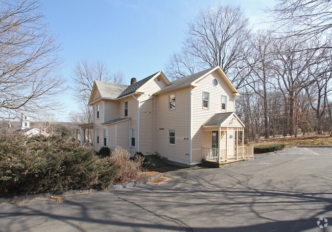
Property Record
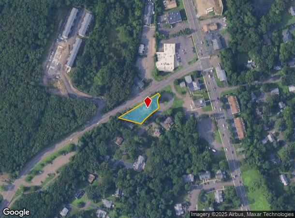
215 Sherman Ave, Hamden, CT 06518

NEARBY LISTINGS FOR SALE OR LEASE
Property Detail
215 Sherman Ave
HAMD-003030-000093
New Haven
Commercialbuilding
Connecticut
X
0000
09009C0292J
0.43 AC
2024
Hamden
2025
Westchester/So Connecticut
165900
New Haven, CT
2,127 SF
DEMOGRAPHICS near 215 Sherman Ave
1 Mile
3 Mile
5 Mile
2024 Total Population
6,961
35,741
99,383
2029 Population
7,028
35,846
99,527
Pop Growth 2024-2029
+ 0.96%
+ 0.29%
+ 0.14%
Average Age
31
41
43
2024 Total Households
1,308
13,352
39,534
HH Growth 2024-2029
+ 1.83%
+ 0.24%
+ 0.17%
Median Household Inc
$110,620
$100,843
$94,198
Avg Household Size
2.30
2.30
2.30
2024 Avg HH Vehicles
2.00
2.00
2.00
Median Home Value
$288,943
$297,238
$290,777
Median Year Built
1979
1974
1968
Nearby Places
Map Layers
Map Styles
 Street
 Aerial
- Restaurants
- Banks
- Shops
- Fitness
- Groceries
PUBLIC TRANSPORTATION
COMMUTER RAIL
Wallingford Amtrak (Amtrak Hartford Line - Amtrak, Hartford Line - Amtrak, Northeast Regional - Amtrak, Valley Flyer - Amtrak)
DRIVE
WALK
Distance
Wallingford Amtrak (Amtrak Hartford Line - Amtrak, Hartford Line - Amtrak, Northeast Regional - Amtrak, Valley Flyer - Amtrak)
11 min
6.3 mi
Wallingford (Hartford Line - CONN DOT)
DRIVE
WALK
Distance
Wallingford (Hartford Line - CONN DOT)
12 min
6.6 mi
AIRPORT
Tweed/New Haven
DRIVE
WALK
Distance
Tweed/New Haven
22 min
13.0 mi
Freight Ports
Port of New Haven
DRIVE
WALK
Distance
Port of New Haven
18 min
10.7 mi
SALE & LEASE HISTORY
LISTING DATE
SALE/LEASE

Oct 23, 2019
For Lease
Nearby Properties
Address
Land Use
TOTAL SIZE
Lot Size
Zoning
Address
Land Use
TOTAL SIZE
Lot Size
Zoning
855,000 SF
142.06 AC
IL80
Address
Land Use
TOTAL SIZE
Lot Size
Zoning
33,122 SF
23.06 AC
T4
Address
Land Use
TOTAL SIZE
Lot Size
Zoning
28,824 SF
44.93 AC
T4
Address
Land Use
TOTAL SIZE
Lot Size
Zoning
15.32 AC
T4
Address
Land Use
TOTAL SIZE
Lot Size
Zoning
30.46 AC
T5
Address
Land Use
TOTAL SIZE
Lot Size
Zoning
8.61 AC
R5
Address
Land Use
TOTAL SIZE
Lot Size
Zoning
10.70 AC
IL30
Address
Land Use
TOTAL SIZE
Lot Size
Zoning
119,658 SF
7.48 AC
O12
Address
Land Use
TOTAL SIZE
Lot Size
Zoning
3 AC
T5
Address
Land Use
TOTAL SIZE
Lot Size
Zoning
17,949 SF
8.02 AC
CB40
Address
Land Use
TOTAL SIZE
Lot Size
Zoning
64,401 SF
19.16 AC
R3
Address
Land Use
TOTAL SIZE
Lot Size
Zoning
85,974 SF
7.05 AC
T-4
Address
Land Use
TOTAL SIZE
Lot Size
Zoning
123,853 SF
3.70 AC
R5
Address
Land Use
TOTAL SIZE
Lot Size
Zoning
9.80 AC
CA20
Address
Land Use
TOTAL SIZE
Lot Size
Zoning
7.04 AC
R5
Address
Land Use
TOTAL SIZE
Lot Size
Zoning
4.45 AC
CB40
Address
Land Use
TOTAL SIZE
Lot Size
Zoning
11.88 AC
T5
Address
Land Use
TOTAL SIZE
Lot Size
Zoning
77,042 SF
39.29 AC
R2
Address
Land Use
TOTAL SIZE
Lot Size
Zoning
8.90 AC
CB40
Address
Land Use
TOTAL SIZE
Lot Size
Zoning
7.46 AC
R5
Address
Land Use
TOTAL SIZE
Lot Size
Zoning
52,689 SF
3.92 AC
T4
Address
Land Use
TOTAL SIZE
Lot Size
Zoning
4.53 AC
T5
Address
Land Use
TOTAL SIZE
Lot Size
Zoning
12.77 AC
R20
Address
Land Use
TOTAL SIZE
Lot Size
Zoning
13.96 AC
IL30
Address
Land Use
TOTAL SIZE
Lot Size
Zoning
95,823 SF
4.23 AC
T4T5
Address
Land Use
TOTAL SIZE
Lot Size
Zoning
50,897 SF
3.86 AC
T4
Address
Land Use
TOTAL SIZE
Lot Size
Zoning
3.81 AC
T5
Address
Land Use
TOTAL SIZE
Lot Size
Zoning
88,351 SF
5.77 AC
IL30
Address
Land Use
TOTAL SIZE
Lot Size
Zoning
91,610 SF
5 AC
R4
Address
Land Use
TOTAL SIZE
Lot Size
Zoning
65,713 SF
15.66 AC
R40
The World's #1 Commercial Real Estate Marketplace
Connect with us
© 2026 CoStar Group
The information above has been obtained from sources believed reliable. While we do not doubt its accuracy we have not verified it and make no guarantee, warranty or representation about it. It is your responsibility to independently confirm its accuracy and completeness. Any projections, opinions, assumptions, or estimates used are for example only and do not represent the current or future performance of the property. The value of this transaction to you depends on tax and other factors which should be evaluated by your tax, financial, and legal advisors. You and your advisors should conduct a careful, independent investigation of the property to determine to your satisfaction the suitability of the property for your needs.