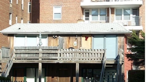
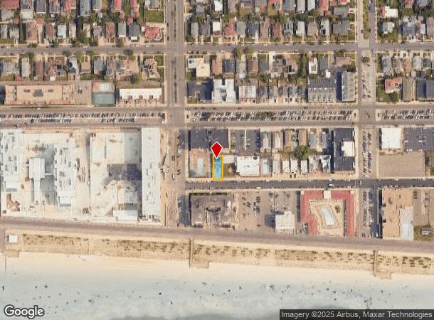
Property Record
215 Shore Rd, Long Beach, NY 11561
NEARBY LISTINGS FOR SALE OR LEASE
-
-
View all Long Beach listings for sale on LoopNet.com
Property Detail
215 Shore Rd
1000-59-130-00-0046-0
TOWN #5 SCH DIST 028
Apartment
Nassau
AE
New York
36059C0308G
46-47
2025
0.09 AC
2025
Long Beach
416702
Long Island (New York)
3,348 SF
Nassau County-Suffolk County, NY
DEMOGRAPHICS near 215 Shore Rd
1 Mile
3 Mile
5 Mile
2024 Total Population
23,493
50,613
177,840
2029 Population
22,929
49,428
174,082
Pop Growth 2024-2029
(2.40%)
(2.34%)
(2.11%)
Average Age
45
44
42
2024 Total Households
10,646
21,511
64,375
HH Growth 2024-2029
(1.90%)
(2.14%)
(2.12%)
Median Household Inc
$107,968
$114,584
$114,989
Avg Household Size
2.10
2.20
2.70
2024 Avg HH Vehicles
1.00
2.00
2.00
Median Home Value
$633,876
$677,255
$695,257
Median Year Built
1961
1959
1956
Nearby Places
- Restaurants
- Banks
- Shops
- Fitness
- Groceries
PUBLIC TRANSPORTATION
COMMUTER RAIL
Long Beach Station (Long Beach Branch - Long Island Rail Road)
DRIVE
WALK
Distance
Long Beach Station (Long Beach Branch - Long Island Rail Road)
3 min
18 min
1.0 mi
Island Park Station (Long Beach Branch - Long Island Rail Road)
DRIVE
WALK
Distance
Island Park Station (Long Beach Branch - Long Island Rail Road)
4 min
1.5 mi
AIRPORT
John F Kennedy International
DRIVE
WALK
Distance
John F Kennedy International
27 min
15.6 mi
LaGuardia
DRIVE
WALK
Distance
LaGuardia
37 min
22.6 mi
Newark Liberty International
DRIVE
WALK
Distance
Newark Liberty International
64 min
42.3 mi
Freight Ports
NY - Red Hook Container Terminal
DRIVE
WALK
Distance
NY - Red Hook Container Terminal
48 min
27.0 mi
Nearby Properties
Address
Land Use
TOTAL SIZE
Lot Size
Zoning
Address
Land Use
TOTAL SIZE
Lot Size
Zoning
Address
Land Use
TOTAL SIZE
Lot Size
Zoning
648 SF
111.40 AC
Address
Land Use
TOTAL SIZE
Lot Size
Zoning
88.30 AC
Address
Land Use
TOTAL SIZE
Lot Size
Zoning
350.74 AC
Address
Land Use
TOTAL SIZE
Lot Size
Zoning
58,400 SF
58.17 AC
Address
Land Use
TOTAL SIZE
Lot Size
Zoning
133.85 AC
Address
Land Use
TOTAL SIZE
Lot Size
Zoning
195,575 SF
35.93 AC
Address
Land Use
TOTAL SIZE
Lot Size
Zoning
197,920 SF
16.50 AC
Address
Land Use
TOTAL SIZE
Lot Size
Zoning
92.92 AC
Address
Land Use
TOTAL SIZE
Lot Size
Zoning
80.84 AC
Address
Land Use
TOTAL SIZE
Lot Size
Zoning
Address
Land Use
TOTAL SIZE
Lot Size
Zoning
66.41 AC
Address
Land Use
TOTAL SIZE
Lot Size
Zoning
6,258 SF
34.59 AC
Address
Land Use
TOTAL SIZE
Lot Size
Zoning
1,664 SF
32.13 AC
Address
Land Use
TOTAL SIZE
Lot Size
Zoning
61.52 AC
Address
Land Use
TOTAL SIZE
Lot Size
Zoning
61.52 AC
Address
Land Use
TOTAL SIZE
Lot Size
Zoning
58.86 AC
Address
Land Use
TOTAL SIZE
Lot Size
Zoning
60.30 AC
Address
Land Use
TOTAL SIZE
Lot Size
Zoning
484,552 SF
11.56 AC
Address
Land Use
TOTAL SIZE
Lot Size
Zoning
37.90 AC
Address
Land Use
TOTAL SIZE
Lot Size
Zoning
120,000 SF
39.77 AC
Address
Land Use
TOTAL SIZE
Lot Size
Zoning
225,176 SF
15.55 AC
Address
Land Use
TOTAL SIZE
Lot Size
Zoning
45,642 SF
5.07 AC
Address
Land Use
TOTAL SIZE
Lot Size
Zoning
197,806 SF
13.36 AC
Address
Land Use
TOTAL SIZE
Lot Size
Zoning
128,438 SF
1.35 AC
Address
Land Use
TOTAL SIZE
Lot Size
Zoning
30.43 AC
Address
Land Use
TOTAL SIZE
Lot Size
Zoning
208,598 SF
3.28 AC
Address
Land Use
TOTAL SIZE
Lot Size
Zoning
5,100 SF
12.27 AC
Address
Land Use
TOTAL SIZE
Lot Size
Zoning
900 SF
35.71 AC
Address
Land Use
TOTAL SIZE
Lot Size
Zoning
The World's #1 Commercial Real Estate Marketplace
Connect with us
© 2025 CoStar Group
The information above has been obtained from sources believed reliable. While we do not doubt its accuracy we have not verified it and make no guarantee, warranty or representation about it. It is your responsibility to independently confirm its accuracy and completeness. Any projections, opinions, assumptions, or estimates used are for example only and do not represent the current or future performance of the property. The value of this transaction to you depends on tax and other factors which should be evaluated by your tax, financial, and legal advisors. You and your advisors should conduct a careful, independent investigation of the property to determine to your satisfaction the suitability of the property for your needs.