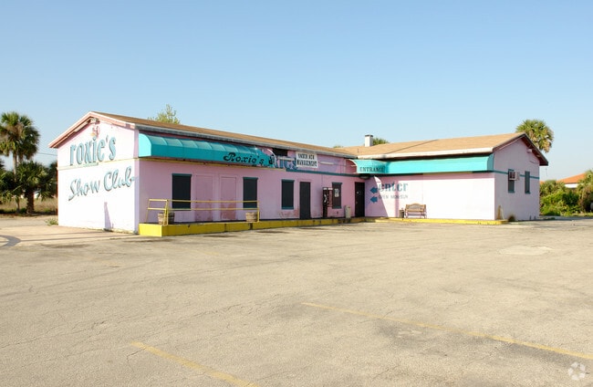
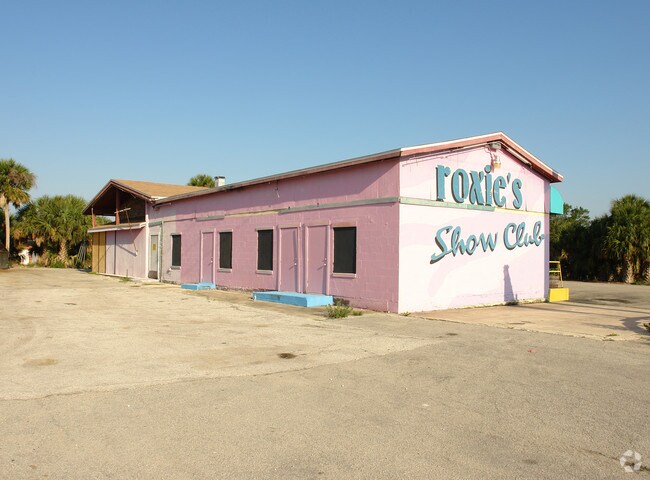
Property Record
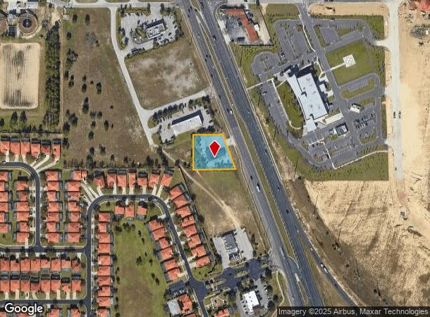
215 Us Highway 27, Clermont, FL 34714
NEARBY LISTINGS FOR SALE OR LEASE
Property Detail
215 Us Highway 27
35-24-26-0004-000-01100
BEG AT INTERSECTION OF W R/W OF HWY 27 WITH S LINE OF N 180.28 FT OF SE 1/4 OF SE 1/4 RUN NWLY ALONG HWY 175 FT W 145 FT S 164.25 FT E 205.38 FT TO POB ORB 974 PG 1482 ORB 1041 PG 2023 ORB 1627 PG 1731
Bartavern
Lake
X
Florida
12105C0100G
11
2024
0.68 AC
2026
Lake County
031318
Orlando
2,717 SF
Orlando-Kissimmee-Sanford, FL
DEMOGRAPHICS near 215 Us Highway 27
1 Mile
3 Mile
5 Mile
2024 Total Population
8,928
52,785
90,153
2029 Population
10,508
64,098
109,160
Pop Growth 2024-2029
+ 17.70%
+ 21.43%
+ 21.08%
Average Age
39
38
37
2024 Total Households
4,349
20,033
32,687
HH Growth 2024-2029
+ 17.27%
+ 21.24%
+ 20.98%
Median Household Inc
$49,671
$61,687
$66,760
Avg Household Size
2.00
2.60
2.70
2024 Avg HH Vehicles
1.00
2.00
2.00
Median Home Value
$168,582
$255,794
$281,928
Median Year Built
2001
2004
2006
Nearby Places
Map Layers
Map Styles
 Street
 Aerial
- Restaurants
- Banks
- Shops
- Fitness
- Groceries
PUBLIC TRANSPORTATION
AIRPORT
Orlando International
DRIVE
WALK
Distance
Orlando International
41 min
28.4 mi
Freight Ports
Port of Tampa Bay
DRIVE
WALK
Distance
Port of Tampa Bay
78 min
64.7 mi
Nearby Properties
Address
Land Use
TOTAL SIZE
Lot Size
Zoning
Address
Land Use
TOTAL SIZE
Lot Size
Zoning
414,620 SF
16.64 AC
P-D
Address
Land Use
TOTAL SIZE
Lot Size
Zoning
480,142 SF
29.57 AC
OPD
Address
Land Use
TOTAL SIZE
Lot Size
Zoning
489,411 SF
19.04 AC
Address
Land Use
TOTAL SIZE
Lot Size
Zoning
364,023 SF
18.77 AC
OPD
Address
Land Use
TOTAL SIZE
Lot Size
Zoning
418,368 SF
12.66 AC
Address
Land Use
TOTAL SIZE
Lot Size
Zoning
128,000 SF
19.60 AC
P-D
Address
Land Use
TOTAL SIZE
Lot Size
Zoning
381,117 SF
10.72 AC
Address
Land Use
TOTAL SIZE
Lot Size
Zoning
321,417 SF
23.19 AC
Address
Land Use
TOTAL SIZE
Lot Size
Zoning
306,139 SF
19.77 AC
P-D
Address
Land Use
TOTAL SIZE
Lot Size
Zoning
333,280 SF
14.73 AC
Address
Land Use
TOTAL SIZE
Lot Size
Zoning
353,423 SF
16.51 AC
PUD
Address
Land Use
TOTAL SIZE
Lot Size
Zoning
316,273 SF
12.24 AC
Address
Land Use
TOTAL SIZE
Lot Size
Zoning
442,457 SF
28.76 AC
RC
Address
Land Use
TOTAL SIZE
Lot Size
Zoning
357,292 SF
1.34 AC
P-D
Address
Land Use
TOTAL SIZE
Lot Size
Zoning
277,616 SF
19.03 AC
Address
Land Use
TOTAL SIZE
Lot Size
Zoning
330,913 SF
16.74 AC
PUD
Address
Land Use
TOTAL SIZE
Lot Size
Zoning
375,326 SF
20.03 AC
PUD
Address
Land Use
TOTAL SIZE
Lot Size
Zoning
272,106 SF
12.22 AC
Address
Land Use
TOTAL SIZE
Lot Size
Zoning
315,346 SF
22.69 AC
PUD
Address
Land Use
TOTAL SIZE
Lot Size
Zoning
299,696 SF
9.79 AC
PUD
Address
Land Use
TOTAL SIZE
Lot Size
Zoning
283,492 SF
11.97 AC
PUD
Address
Land Use
TOTAL SIZE
Lot Size
Zoning
189.88 AC
P-D
Address
Land Use
TOTAL SIZE
Lot Size
Zoning
114,592 SF
18.46 AC
OCT
Address
Land Use
TOTAL SIZE
Lot Size
Zoning
196,553 SF
6.13 AC
Address
Land Use
TOTAL SIZE
Lot Size
Zoning
71,280 SF
4.91 AC
P-D
Address
Land Use
TOTAL SIZE
Lot Size
Zoning
97.51 AC
P-D
Address
Land Use
TOTAL SIZE
Lot Size
Zoning
71,280 SF
0.59 AC
P-D
Address
Land Use
TOTAL SIZE
Lot Size
Zoning
330,563 SF
20.07 AC
PUD
Address
Land Use
TOTAL SIZE
Lot Size
Zoning
16,371 SF
266.28 AC
C1
Address
Land Use
TOTAL SIZE
Lot Size
Zoning
154,933 SF
20.94 AC
OPD
The World's #1 Commercial Real Estate Marketplace
Connect with us
© 2025 CoStar Group
The information above has been obtained from sources believed reliable. While we do not doubt its accuracy we have not verified it and make no guarantee, warranty or representation about it. It is your responsibility to independently confirm its accuracy and completeness. Any projections, opinions, assumptions, or estimates used are for example only and do not represent the current or future performance of the property. The value of this transaction to you depends on tax and other factors which should be evaluated by your tax, financial, and legal advisors. You and your advisors should conduct a careful, independent investigation of the property to determine to your satisfaction the suitability of the property for your needs.