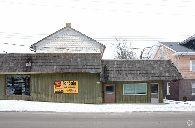
Property Record
215 W Cedar St, Chillicothe, IL 61523

Save to a Folder
{{folder.Name}}
{{folder.ListingIds.length}} Properties
{{folder.ListingIds.length}} Property
Create a New Folder
Property Detail
215 W Cedar St
Peoria
JAMISON & HARTS ADD SW 1/4 SEC 21-11N-9E LOTS 2 & 3 BLK 17
Peoria, IL
PEORIA
0521310013
Illinois
Commercialnec
2,3
2024
0.50 AC
2024
Outlying Peoria County
003602
NEARBY LISTINGS FOR SALE OR LEASE
DEMOGRAPHICS near 215 W Cedar St
1 mile
3 mile
5 mile
2025 Total Population
3,843
6,818
9,854
2030 Population
3,798
6,726
9,718
Pop Growth 2025-2030
(1.17%)
(1.35%)
(1.38%)
Average Age
42
42
43
2025 Total Households
1,681
2,863
4,084
HH Growth 2025-2030
(1.13%)
(1.33%)
(1.37%)
Median Household Inc
$62,699
$67,943
$75,171
Avg Household Size
2.20
2.30
2.40
2025 Avg HH Vehicles
2.00
2.00
2.00
Median Home Value
$117,932
$139,043
$154,594
Median Year Built
1958
1966
1968
Nearby Places
Map Layers
Map Styles
 Street
 Aerial
Layers
 Traffic
 Biking
Places
Listings with unknown addresses are not visible on the map
- Restaurants
- Banks
- Shops
- Fitness
- Groceries
PUBLIC TRANSPORTATION
AIRPORT
General Downing - Peoria International
Drive
Walk
Distance
General Downing - Peoria International
36 min
25.6 mi
Nearby Properties
Address
Land Use
TOTAL SIZE
Lot Size
Zoning
Address
Land Use
TOTAL SIZE
Lot Size
Zoning
3,540 SF
6.08 AC
Address
Land Use
TOTAL SIZE
Lot Size
Zoning
Address
Land Use
TOTAL SIZE
Lot Size
Zoning
3.06 AC
Address
Land Use
TOTAL SIZE
Lot Size
Zoning
1.76 AC
Address
Land Use
TOTAL SIZE
Lot Size
Zoning
0.22 AC
Address
Land Use
TOTAL SIZE
Lot Size
Zoning
2,728 SF
1.97 AC
Address
Land Use
TOTAL SIZE
Lot Size
Zoning
Address
Land Use
TOTAL SIZE
Lot Size
Zoning
Address
Land Use
TOTAL SIZE
Lot Size
Zoning
2,406 SF
0.92 AC
Address
Land Use
TOTAL SIZE
Lot Size
Zoning
1.63 AC
Address
Land Use
TOTAL SIZE
Lot Size
Zoning
0.50 AC
Address
Land Use
TOTAL SIZE
Lot Size
Zoning
1.14 AC
Address
Land Use
TOTAL SIZE
Lot Size
Zoning
2,168 SF
0.84 AC
Address
Land Use
TOTAL SIZE
Lot Size
Zoning
1,352 SF
1.39 AC
Address
Land Use
TOTAL SIZE
Lot Size
Zoning
Address
Land Use
TOTAL SIZE
Lot Size
Zoning
3.71 AC
Address
Land Use
TOTAL SIZE
Lot Size
Zoning
732 SF
0.66 AC
Address
Land Use
TOTAL SIZE
Lot Size
Zoning
0.80 AC
Address
Land Use
TOTAL SIZE
Lot Size
Zoning
0.62 AC
Address
Land Use
TOTAL SIZE
Lot Size
Zoning
1,344 SF
0.93 AC
Address
Land Use
TOTAL SIZE
Lot Size
Zoning
1,000 SF
14.79 AC
Address
Land Use
TOTAL SIZE
Lot Size
Zoning
Address
Land Use
TOTAL SIZE
Lot Size
Zoning
Address
Land Use
TOTAL SIZE
Lot Size
Zoning
Address
Land Use
TOTAL SIZE
Lot Size
Zoning
0.44 AC
Address
Land Use
TOTAL SIZE
Lot Size
Zoning
0.63 AC
Address
Land Use
TOTAL SIZE
Lot Size
Zoning
0.29 AC
Address
Land Use
TOTAL SIZE
Lot Size
Zoning
1.14 AC
Address
Land Use
TOTAL SIZE
Lot Size
Zoning
0.43 AC
The World's #1 Commercial Real Estate Marketplace
Connect with us
© 2026 CoStar Group
The information above has been obtained from sources believed reliable. While we do not doubt its accuracy we have not verified it and make no guarantee, warranty or representation about it. It is your responsibility to independently confirm its accuracy and completeness. Any projections, opinions, assumptions, or estimates used are for example only and do not represent the current or future performance of the property. The value of this transaction to you depends on tax and other factors which should be evaluated by your tax, financial, and legal advisors. You and your advisors should conduct a careful, independent investigation of the property to determine to your satisfaction the suitability of the property for your needs.