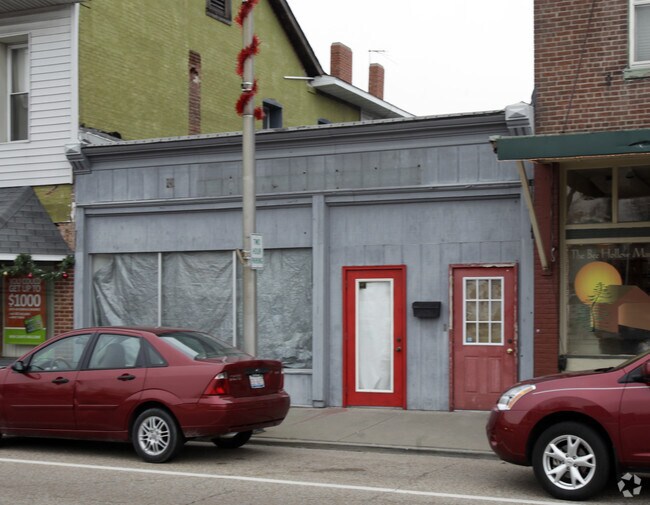
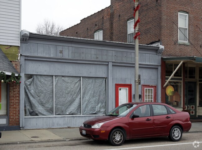
Property Record
215 W Main St, Mascoutah, IL 62258


NEARBY LISTINGS FOR SALE OR LEASE
-
-
View all Mascoutah listings for sale on LoopNet.com
Property Detail
215 W Main St
St. Louis
Dietzs Add
St. Louis, MO-IL
DIETZS ADD LOT/SEC-7-BLK/RG-1 LOTS 6 THRU 12 W 1/2 LT 5 & PT LT 4 & PT VAC ALLEY A02533302
10-31.0-220-025
St. Clair
Restaurantdrivein
Illinois
2024
4,6
2024
0.92 AC
504357
Metro East Illinois
4,054 SF
DEMOGRAPHICS near 215 W Main St
1 Mile
3 Mile
5 Mile
2024 Total Population
4,267
8,663
12,516
2029 Population
4,155
8,418
12,107
Pop Growth 2024-2029
(2.62%)
(2.83%)
(3.27%)
Average Age
39
39
36
2024 Total Households
1,646
3,179
4,363
HH Growth 2024-2029
(2.55%)
(2.77%)
(3.19%)
Median Household Inc
$92,165
$93,700
$90,400
Avg Household Size
2.50
2.60
2.80
2024 Avg HH Vehicles
2.00
2.00
2.00
Median Home Value
$185,889
$212,841
$218,452
Median Year Built
1977
1980
1988
Nearby Places
Map Layers
Map Styles
 Street
 Aerial
- Restaurants
- Banks
- Shops
- Fitness
- Groceries
PUBLIC TRANSPORTATION
COMMUTER RAIL
Shiloh-Scott (Lambert Airport Shiloh-Scott - St. Louis MetroLink (MetroLink))
DRIVE
WALK
Distance
Shiloh-Scott (Lambert Airport Shiloh-Scott - St. Louis MetroLink (MetroLink))
13 min
7.3 mi
College (Lambert Airport Shiloh-Scott - St. Louis MetroLink (MetroLink))
DRIVE
WALK
Distance
College (Lambert Airport Shiloh-Scott - St. Louis MetroLink (MetroLink))
14 min
7.8 mi
AIRPORT
Scott AFB/Midamerica St Louis
DRIVE
WALK
Distance
Scott AFB/Midamerica St Louis
16 min
7.9 mi
Freight Ports
Port Milwaukee
DRIVE
WALK
Distance
Port Milwaukee
425 min
367.2 mi
Nearby Properties
Address
Land Use
TOTAL SIZE
Lot Size
Zoning
Address
Land Use
TOTAL SIZE
Lot Size
Zoning
5.25 AC
Address
Land Use
TOTAL SIZE
Lot Size
Zoning
4,480 SF
10.76 AC
Address
Land Use
TOTAL SIZE
Lot Size
Zoning
7,740 SF
3.05 AC
Address
Land Use
TOTAL SIZE
Lot Size
Zoning
4,624 SF
3.18 AC
Address
Land Use
TOTAL SIZE
Lot Size
Zoning
51,250 SF
9.70 AC
Address
Land Use
TOTAL SIZE
Lot Size
Zoning
100,000 SF
4.60 AC
Address
Land Use
TOTAL SIZE
Lot Size
Zoning
19,313 SF
1.43 AC
Address
Land Use
TOTAL SIZE
Lot Size
Zoning
27,954 SF
2.04 AC
Address
Land Use
TOTAL SIZE
Lot Size
Zoning
15,240 SF
5.95 AC
Address
Land Use
TOTAL SIZE
Lot Size
Zoning
15,315 SF
1.67 AC
Address
Land Use
TOTAL SIZE
Lot Size
Zoning
73,800 SF
6.50 AC
Address
Land Use
TOTAL SIZE
Lot Size
Zoning
28,000 SF
7.69 AC
Address
Land Use
TOTAL SIZE
Lot Size
Zoning
24,720 SF
9.88 AC
Address
Land Use
TOTAL SIZE
Lot Size
Zoning
14,617 SF
1.83 AC
Address
Land Use
TOTAL SIZE
Lot Size
Zoning
4,352 SF
0.97 AC
Address
Land Use
TOTAL SIZE
Lot Size
Zoning
5,273 SF
6.97 AC
Address
Land Use
TOTAL SIZE
Lot Size
Zoning
1,248 SF
1.05 AC
Address
Land Use
TOTAL SIZE
Lot Size
Zoning
7,426 SF
0.81 AC
Address
Land Use
TOTAL SIZE
Lot Size
Zoning
3,924 SF
1.05 AC
Address
Land Use
TOTAL SIZE
Lot Size
Zoning
19,200 SF
5.87 AC
Address
Land Use
TOTAL SIZE
Lot Size
Zoning
19,678 SF
Address
Land Use
TOTAL SIZE
Lot Size
Zoning
Address
Land Use
TOTAL SIZE
Lot Size
Zoning
1.52 AC
Address
Land Use
TOTAL SIZE
Lot Size
Zoning
3,802 SF
1.85 AC
Address
Land Use
TOTAL SIZE
Lot Size
Zoning
3,626 SF
1.54 AC
Address
Land Use
TOTAL SIZE
Lot Size
Zoning
4,580 SF
1.33 AC
Address
Land Use
TOTAL SIZE
Lot Size
Zoning
2,550 SF
1.20 AC
Address
Land Use
TOTAL SIZE
Lot Size
Zoning
6,417 SF
0.68 AC
Address
Land Use
TOTAL SIZE
Lot Size
Zoning
5,513 SF
0.69 AC
Address
Land Use
TOTAL SIZE
Lot Size
Zoning
32,862 SF
5.51 AC
The World's #1 Commercial Real Estate Marketplace
Connect with us
© 2026 CoStar Group
The information above has been obtained from sources believed reliable. While we do not doubt its accuracy we have not verified it and make no guarantee, warranty or representation about it. It is your responsibility to independently confirm its accuracy and completeness. Any projections, opinions, assumptions, or estimates used are for example only and do not represent the current or future performance of the property. The value of this transaction to you depends on tax and other factors which should be evaluated by your tax, financial, and legal advisors. You and your advisors should conduct a careful, independent investigation of the property to determine to your satisfaction the suitability of the property for your needs.