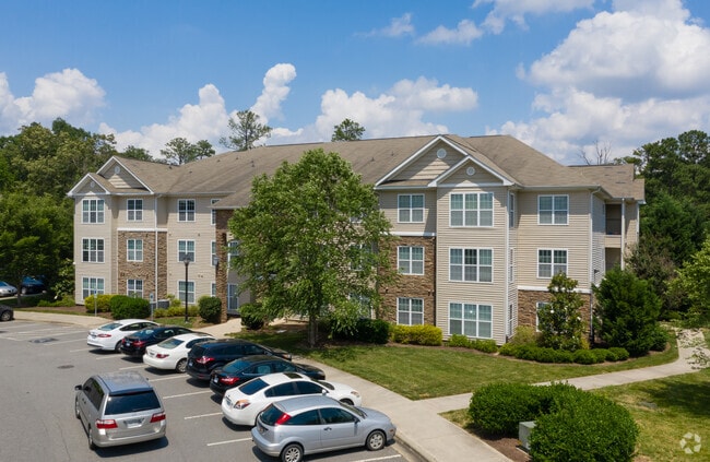
Property Record
215 William Penn Plz, Durham, NC 27704


Property Detail
215 William Penn Plz
172255
PROP-BRC INDEPENDENCE PAR K LLC/LT#03 GR PT PL:000186-000331
Gardenaptcourtapt5plusunits
Durham
OI(D)
North Carolina
B and X Area of moderate flood hazard, usually the area between the limits of the 100-year and 500-year floods.
3
2025
22.99 AC
2025
Weaver
001709
Raleigh/Durham
6,753 SF
Durham-Chapel Hill, NC
NEARBY LISTINGS FOR SALE OR LEASE
-
-
View all Durham listings for sale on LoopNet.com
DEMOGRAPHICS near 215 William Penn Plz
1 mile
3 mile
5 mile
2025 Total Population
9,573
63,377
154,604
2030 Population
10,103
66,971
163,852
Pop Growth 2025-2030
+ 5.54%
+ 5.67%
+ 5.98%
Average Age
38
39
38
2025 Total Households
3,735
26,725
62,743
HH Growth 2025-2030
+ 5.70%
+ 5.95%
+ 6.42%
Median Household Inc
$50,350
$71,405
$68,482
Avg Household Size
2.40
2.30
2.30
2025 Avg HH Vehicles
1.00
2.00
2.00
Median Home Value
$333,623
$390,028
$388,275
Median Year Built
1989
1983
1983
Nearby Places
Map Layers
Map Styles
 Street
 Aerial
Layers
 Traffic
 Biking
Places
Listings with unknown addresses are not visible on the map
- Restaurants
- Banks
- Shops
- Fitness
- Groceries
PUBLIC TRANSPORTATION
COMMUTER RAIL
Durham Amtrak Station (Carolinian - Amtrak, Piedmont - Amtrak)
Drive
Walk
Distance
Durham Amtrak Station (Carolinian - Amtrak, Piedmont - Amtrak)
10 min
4.0 mi
AIRPORT
Raleigh-Durham International
Drive
Walk
Distance
Raleigh-Durham International
28 min
16.2 mi
Freight Ports
Virginia Port Authority - Richmond
Drive
Walk
Distance
Virginia Port Authority - Richmond
170 min
147.0 mi
Nearby Properties
Address
Land Use
TOTAL SIZE
Lot Size
Zoning
Address
Land Use
TOTAL SIZE
Lot Size
Zoning
749,544 SF
100.49 AC
OI,RS-8
Address
Land Use
TOTAL SIZE
Lot Size
Zoning
26,512 SF
6.40 AC
CD-C
Address
Land Use
TOTAL SIZE
Lot Size
Zoning
758,666 SF
99.64 AC
PDR 2.000
Address
Land Use
TOTAL SIZE
Lot Size
Zoning
24,741 SF
5.67 AC
CD-S1
Address
Land Use
TOTAL SIZE
Lot Size
Zoning
3.20 AC
CD-S1
Address
Land Use
TOTAL SIZE
Lot Size
Zoning
69,430 SF
2.61 AC
DD-C
Address
Land Use
TOTAL SIZE
Lot Size
Zoning
12,440 SF
36.51 AC
PDR 2.000
Address
Land Use
TOTAL SIZE
Lot Size
Zoning
218,946 SF
1.91 AC
DD-S1
Address
Land Use
TOTAL SIZE
Lot Size
Zoning
368,569 SF
2.77 AC
Address
Land Use
TOTAL SIZE
Lot Size
Zoning
250,392 SF
16.67 AC
DD-S2
Address
Land Use
TOTAL SIZE
Lot Size
Zoning
485,295 SF
27.35 AC
RS-8
Address
Land Use
TOTAL SIZE
Lot Size
Zoning
69.37 AC
IL
Address
Land Use
TOTAL SIZE
Lot Size
Zoning
137,472 SF
1.04 AC
DD-C
Address
Land Use
TOTAL SIZE
Lot Size
Zoning
3.61 AC
DD-S1
Address
Land Use
TOTAL SIZE
Lot Size
Zoning
114,840 SF
1.03 AC
DD-S1
Address
Land Use
TOTAL SIZE
Lot Size
Zoning
166,866 SF
76.52 AC
RS-10
Address
Land Use
TOTAL SIZE
Lot Size
Zoning
12,468 SF
13.33 AC
RU-M(D)
Address
Land Use
TOTAL SIZE
Lot Size
Zoning
97.24 AC
UC(D)
Address
Land Use
TOTAL SIZE
Lot Size
Zoning
6,822 SF
24.64 AC
PDR 2.000
Address
Land Use
TOTAL SIZE
Lot Size
Zoning
354,480 SF
34.53 AC
IL
Address
Land Use
TOTAL SIZE
Lot Size
Zoning
2,104 SF
0.49 AC
DD-S1
Address
Land Use
TOTAL SIZE
Lot Size
Zoning
4,644 SF
19.04 AC
RU-M
Address
Land Use
TOTAL SIZE
Lot Size
Zoning
15,720 SF
16.18 AC
PDR 10.000
Address
Land Use
TOTAL SIZE
Lot Size
Zoning
19,769 SF
9.12 AC
OI(D)
Address
Land Use
TOTAL SIZE
Lot Size
Zoning
7,056 SF
25.68 AC
RS-M
Address
Land Use
TOTAL SIZE
Lot Size
Zoning
117,537 SF
4.39 AC
CD-P(N)
Address
Land Use
TOTAL SIZE
Lot Size
Zoning
6,936 SF
11.42 AC
PDR 2.000
Address
Land Use
TOTAL SIZE
Lot Size
Zoning
176,751 SF
17.77 AC
OI
Address
Land Use
TOTAL SIZE
Lot Size
Zoning
8,824 SF
15.96 AC
RS-M
The World's #1 Commercial Real Estate Marketplace
Connect with us
© 2026 CoStar Group
The information above has been obtained from sources believed reliable. While we do not doubt its accuracy we have not verified it and make no guarantee, warranty or representation about it. It is your responsibility to independently confirm its accuracy and completeness. Any projections, opinions, assumptions, or estimates used are for example only and do not represent the current or future performance of the property. The value of this transaction to you depends on tax and other factors which should be evaluated by your tax, financial, and legal advisors. You and your advisors should conduct a careful, independent investigation of the property to determine to your satisfaction the suitability of the property for your needs.