Property Record
2150 Association Dr, Okemos, MI 48864
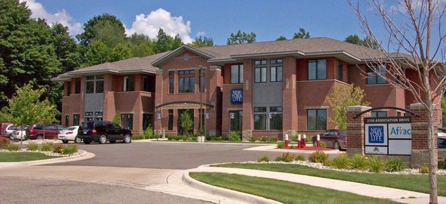

Property Detail
2150 Association Dr
02-02-33-453-004
UNIT 4, SCHOLLE POND OFFICE PARK INGHAM CO CONDO SUB PLAN NO 115 THRU 3RD AMEND SEC 33, T4NR1W 2.14 A
Officebuilding
Ingham
PO
Michigan
B and X Area of moderate flood hazard, usually the area between the limits of the 100-year and 500-year floods.
2.08 AC
2025
East Lansing
2025
West Michigan
005003
Lansing-East Lansing, MI
21,388 SF
NEARBY LISTINGS FOR SALE OR LEASE
DEMOGRAPHICS near 2150 Association Dr
1 mile
3 mile
5 mile
2025 Total Population
6,149
22,645
90,927
2030 Population
6,293
22,915
93,785
Pop Growth 2025-2030
+ 2.34%
+ 1.19%
+ 3.14%
Average Age
38
38
34
2025 Total Households
2,350
9,022
34,334
HH Growth 2025-2030
+ 2.51%
+ 1.27%
+ 3.32%
Median Household Inc
$108,674
$103,644
$70,566
Avg Household Size
2.60
2.40
2.20
2025 Avg HH Vehicles
2.00
2.00
2.00
Median Home Value
$378,622
$357,361
$296,145
Median Year Built
1987
1984
1982
Nearby Places
Map Layers
Map Styles
 Street
 Aerial
Layers
 Traffic
 Biking
Places
Listings with unknown addresses are not visible on the map
- Restaurants
- Banks
- Shops
- Fitness
- Groceries
PUBLIC TRANSPORTATION
COMMUTER RAIL
Drive
Walk
Distance
12 min
7.6 mi
AIRPORT
Capital Region International
Drive
Walk
Distance
Capital Region International
23 min
14.0 mi
SALE & LEASE HISTORY
LISTING DATE
SALE/LEASE

Sep 27, 2021
For Sale
Sep 26, 2024
For Lease
Sep 25, 2016
For Lease
Mar 06, 2025
For Lease
Aug 09, 2017
For Lease
Nearby Properties
Address
Land Use
TOTAL SIZE
Lot Size
Zoning
Address
Land Use
TOTAL SIZE
Lot Size
Zoning
49,959 SF
15.71 AC
RP
Address
Land Use
TOTAL SIZE
Lot Size
Zoning
98,513 SF
7.86 AC
C-2
Address
Land Use
TOTAL SIZE
Lot Size
Zoning
8,775 SF
78.38 AC
G-1 BUS
Address
Land Use
TOTAL SIZE
Lot Size
Zoning
251,183 SF
80.28 AC
Address
Land Use
TOTAL SIZE
Lot Size
Zoning
812,293 SF
62.18 AC
C-3
Address
Land Use
TOTAL SIZE
Lot Size
Zoning
51,122 SF
9.05 AC
RAA
Address
Land Use
TOTAL SIZE
Lot Size
Zoning
129,030 SF
RP
Address
Land Use
TOTAL SIZE
Lot Size
Zoning
61,198 SF
13.10 AC
C-2
Address
Land Use
TOTAL SIZE
Lot Size
Zoning
119,182 SF
19.33 AC
C-3
Address
Land Use
TOTAL SIZE
Lot Size
Zoning
38,332 SF
7.44 AC
C-2
Address
Land Use
TOTAL SIZE
Lot Size
Zoning
25,308 SF
45.28 AC
RD
Address
Land Use
TOTAL SIZE
Lot Size
Zoning
15,067 SF
15.64 AC
RC
Address
Land Use
TOTAL SIZE
Lot Size
Zoning
25,430 SF
12.03 AC
RC
Address
Land Use
TOTAL SIZE
Lot Size
Zoning
78,098 SF
5.33 AC
C-3
Address
Land Use
TOTAL SIZE
Lot Size
Zoning
26,458 SF
16.65 AC
B-1
Address
Land Use
TOTAL SIZE
Lot Size
Zoning
11,374 SF
21.59 AC
RC
Address
Land Use
TOTAL SIZE
Lot Size
Zoning
119,182 SF
9.68 AC
Address
Land Use
TOTAL SIZE
Lot Size
Zoning
15,760 SF
8.49 AC
RCC
Address
Land Use
TOTAL SIZE
Lot Size
Zoning
72,020 SF
2.50 AC
C-2
Address
Land Use
TOTAL SIZE
Lot Size
Zoning
44,572 SF
4.23 AC
GO
Address
Land Use
TOTAL SIZE
Lot Size
Zoning
53,177 SF
9.03 AC
RA
Address
Land Use
TOTAL SIZE
Lot Size
Zoning
40,078 SF
19.38 AC
RC
Address
Land Use
TOTAL SIZE
Lot Size
Zoning
223,026 SF
30.20 AC
C-2
Address
Land Use
TOTAL SIZE
Lot Size
Zoning
64,646 SF
3.54 AC
PO
Address
Land Use
TOTAL SIZE
Lot Size
Zoning
18,648 SF
5.89 AC
Address
Land Use
TOTAL SIZE
Lot Size
Zoning
34,322 SF
16.53 AC
RC
Address
Land Use
TOTAL SIZE
Lot Size
Zoning
23,454 SF
3.68 AC
Address
Land Use
TOTAL SIZE
Lot Size
Zoning
65,976 SF
2.79 AC
C-2
Address
Land Use
TOTAL SIZE
Lot Size
Zoning
9,094 SF
7.20 AC
C-3
Address
Land Use
TOTAL SIZE
Lot Size
Zoning
14,982 SF
9.80 AC
RC
The World's #1 Commercial Real Estate Marketplace
Connect with us
© 2026 CoStar Group
The information above has been obtained from sources believed reliable. While we do not doubt its accuracy we have not verified it and make no guarantee, warranty or representation about it. It is your responsibility to independently confirm its accuracy and completeness. Any projections, opinions, assumptions, or estimates used are for example only and do not represent the current or future performance of the property. The value of this transaction to you depends on tax and other factors which should be evaluated by your tax, financial, and legal advisors. You and your advisors should conduct a careful, independent investigation of the property to determine to your satisfaction the suitability of the property for your needs.