Property Record
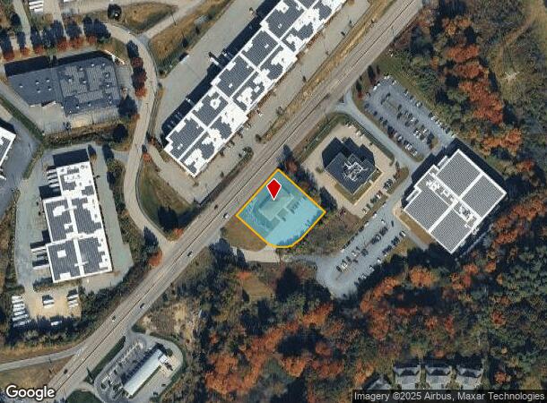
2150 Route 1, Walpole, MA 02081
NEARBY LISTINGS FOR SALE OR LEASE
Property Detail
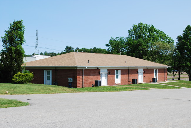
2150 Route 1
Officebuilding
Norfolk
X
Massachusetts
25021C0351F
0.92 AC
2025
I-95 Corridor South
2025
Boston
411102
Boston-Cambridge-Newton, MA-NH
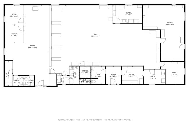
4,312 SF
WALP-000054-000019
DEMOGRAPHICS near 2150 Route 1
1 Mile
3 Mile
5 Mile
2024 Total Population
2,545
28,973
79,863
2029 Population
2,452
29,021
79,562
Pop Growth 2024-2029
(3.65%)
+ 0.17%
(0.38%)
Average Age
39
41
41
2024 Total Households
923
10,578
29,171
HH Growth 2024-2029
(4.12%)
+ 0.26%
(0.40%)
Median Household Inc
$137,239
$124,836
$133,454
Avg Household Size
2.60
2.70
2.70
2024 Avg HH Vehicles
2.00
2.00
2.00
Median Home Value
$678,261
$621,106
$654,391
Median Year Built
1996
1973
1973
Nearby Places
Map Layers
Map Styles
 Street
 Aerial
- Restaurants
- Banks
- Shops
- Fitness
- Groceries
PUBLIC TRANSPORTATION
COMMUTER RAIL
Walpole (Foxboro Line (Special Events Only) - Massachusetts Bay Transportation Authority Commuter Rail (Purple Line), Franklin Line - Massachusetts Bay Transportation Authority Commuter Rail (Purple Line))
DRIVE
WALK
Distance
Walpole (Foxboro Line (Special Events Only) - Massachusetts Bay Transportation Authority Commuter Rail (Purple Line), Franklin Line - Massachusetts Bay Transportation Authority Commuter Rail (Purple Line))
6 min
3.1 mi
Foxboro (Special Events Only) (Foxboro Line (Special Events Only) - Massachusetts Bay Transportation Authority Commuter Rail (Purple Line))
DRIVE
WALK
Distance
Foxboro (Special Events Only) (Foxboro Line (Special Events Only) - Massachusetts Bay Transportation Authority Commuter Rail (Purple Line))
6 min
3.7 mi
AIRPORT
General Edward Lawrence Logan International
DRIVE
WALK
Distance
General Edward Lawrence Logan International
40 min
27.8 mi
Rhode Island Tf Green International
DRIVE
WALK
Distance
Rhode Island Tf Green International
51 min
36.1 mi
Worcester Regional
DRIVE
WALK
Distance
Worcester Regional
70 min
49.6 mi
SALE & LEASE HISTORY
LISTING DATE
SALE/LEASE

May 30, 2018
For Sale
Mar 24, 2025
For Sale
Mar 13, 2019
For Sale
Jun 07, 2019
For Lease
Jun 07, 2019
For Sale
Jul 11, 2018
For Lease
Jan 22, 2020
For Lease
Jan 20, 2020
For Sale
Nearby Properties
Address
Land Use
TOTAL SIZE
Lot Size
Zoning
Address
Land Use
TOTAL SIZE
Lot Size
Zoning
Address
Land Use
TOTAL SIZE
Lot Size
Zoning
198,498 SF
14 AC
Address
Land Use
TOTAL SIZE
Lot Size
Zoning
205,897 SF
37.36 AC
Address
Land Use
TOTAL SIZE
Lot Size
Zoning
245,693 SF
2.57 AC
Address
Land Use
TOTAL SIZE
Lot Size
Zoning
2,385 SF
21.39 AC
Address
Land Use
TOTAL SIZE
Lot Size
Zoning
1,080 SF
10.07 AC
Address
Land Use
TOTAL SIZE
Lot Size
Zoning
14.33 AC
Address
Land Use
TOTAL SIZE
Lot Size
Zoning
211,362 SF
2.39 AC
Address
Land Use
TOTAL SIZE
Lot Size
Zoning
41.28 AC
Address
Land Use
TOTAL SIZE
Lot Size
Zoning
89,960 SF
52.40 AC
Address
Land Use
TOTAL SIZE
Lot Size
Zoning
11.98 AC
Address
Land Use
TOTAL SIZE
Lot Size
Zoning
83,014 SF
129.67 AC
Address
Land Use
TOTAL SIZE
Lot Size
Zoning
126,484 SF
1.61 AC
Address
Land Use
TOTAL SIZE
Lot Size
Zoning
93,218 SF
9.68 AC
LI
Address
Land Use
TOTAL SIZE
Lot Size
Zoning
59,390 SF
5.69 AC
Address
Land Use
TOTAL SIZE
Lot Size
Zoning
64,887 SF
21.10 AC
Address
Land Use
TOTAL SIZE
Lot Size
Zoning
54,948 SF
11.43 AC
Address
Land Use
TOTAL SIZE
Lot Size
Zoning
814.08 AC
Address
Land Use
TOTAL SIZE
Lot Size
Zoning
56,414 SF
7.63 AC
Address
Land Use
TOTAL SIZE
Lot Size
Zoning
7.86 AC
Address
Land Use
TOTAL SIZE
Lot Size
Zoning
102,024 SF
9.97 AC
LI
Address
Land Use
TOTAL SIZE
Lot Size
Zoning
147,984 SF
20.57 AC
Address
Land Use
TOTAL SIZE
Lot Size
Zoning
11.97 AC
Address
Land Use
TOTAL SIZE
Lot Size
Zoning
101,171 SF
11.12 AC
LI
Address
Land Use
TOTAL SIZE
Lot Size
Zoning
109,094 SF
6.19 AC
Address
Land Use
TOTAL SIZE
Lot Size
Zoning
124,519 SF
14.22 AC
LI
Address
Land Use
TOTAL SIZE
Lot Size
Zoning
246,854 SF
31.90 AC
Address
Land Use
TOTAL SIZE
Lot Size
Zoning
80,453 SF
10.79 AC
Address
Land Use
TOTAL SIZE
Lot Size
Zoning
91,216 SF
1.18 AC
Address
Land Use
TOTAL SIZE
Lot Size
Zoning
61,880 SF
6.06 AC
The World's #1 Commercial Real Estate Marketplace
Connect with us
© 2025 CoStar Group
The information above has been obtained from sources believed reliable. While we do not doubt its accuracy we have not verified it and make no guarantee, warranty or representation about it. It is your responsibility to independently confirm its accuracy and completeness. Any projections, opinions, assumptions, or estimates used are for example only and do not represent the current or future performance of the property. The value of this transaction to you depends on tax and other factors which should be evaluated by your tax, financial, and legal advisors. You and your advisors should conduct a careful, independent investigation of the property to determine to your satisfaction the suitability of the property for your needs.