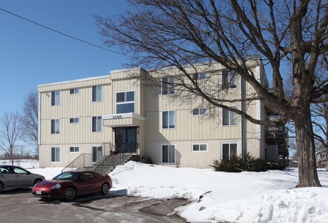
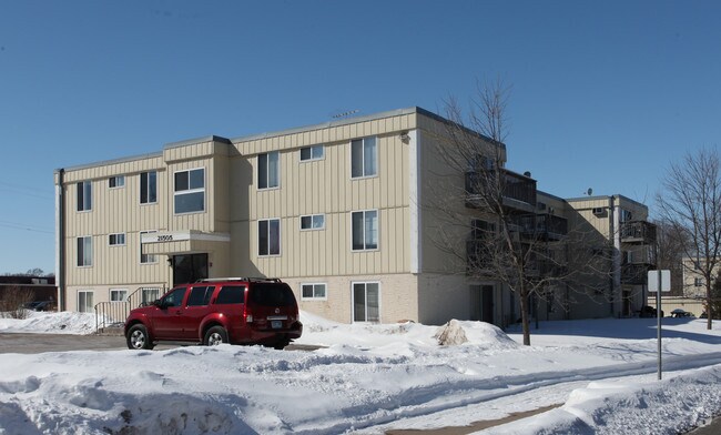
Property Record
21505 Maple Ave, Rogers, MN 55374
Property Detail
21505 Maple Ave
Minneapolis-St. Paul-Bloomington, MN-WI
A SUGAR MAPLES THAT PART OF OUTLOT A LYING E OF A LINE PAR WITH AND DIS 419 87/100 FT WLY AS MEAS ALONG NLY LINE THOF FROM E LINE THOF IRREGULAR
23-120-23-34-0021
Hennepin
Apartment
Minnesota
B and X Area of moderate flood hazard, usually the area between the limits of the 100-year and 500-year floods.
a
2024
1.16 AC
2024
Outlying Hennepin Far Western Suburbs
026912
Minneapolis/St Paul
NEARBY LISTINGS FOR SALE OR LEASE
-
-
View all Rogers listings for sale on LoopNet.com
DEMOGRAPHICS near 21505 Maple Ave
1 mile
3 mile
5 mile
2025 Total Population
4,310
16,301
39,976
2030 Population
4,493
16,908
42,044
Pop Growth 2025-2030
+ 4.25%
+ 3.72%
+ 5.17%
Average Age
39
39
39
2025 Total Households
1,574
5,541
13,858
HH Growth 2025-2030
+ 4.26%
+ 3.74%
+ 5.14%
Median Household Inc
$155,929
$149,106
$139,748
Avg Household Size
2.70
2.90
2.80
2025 Avg HH Vehicles
2.00
2.00
2.00
Median Home Value
$463,694
$445,784
$452,181
Median Year Built
2005
2003
2003
Nearby Places
Map Layers
Map Styles
 Street
 Aerial
Layers
 Traffic
 Biking
Places
Listings with unknown addresses are not visible on the map
- Restaurants
- Banks
- Shops
- Fitness
- Groceries
PUBLIC TRANSPORTATION
COMMUTER RAIL
Elk River Station (Northstar Corridor - Northstar Commuter Rail)
Drive
Walk
Distance
Elk River Station (Northstar Corridor - Northstar Commuter Rail)
14 min
9.0 mi
AIRPORT
Minneapolis-St Paul International/Wold-Chamberlain
Drive
Walk
Distance
Minneapolis-St Paul International/Wold-Chamberlain
49 min
37.6 mi
Nearby Properties
Address
Land Use
TOTAL SIZE
Lot Size
Zoning
Address
Land Use
TOTAL SIZE
Lot Size
Zoning
42.21 AC
Address
Land Use
TOTAL SIZE
Lot Size
Zoning
36.67 AC
Address
Land Use
TOTAL SIZE
Lot Size
Zoning
21.50 AC
Address
Land Use
TOTAL SIZE
Lot Size
Zoning
30.13 AC
Address
Land Use
TOTAL SIZE
Lot Size
Zoning
Address
Land Use
TOTAL SIZE
Lot Size
Zoning
3.32 AC
Address
Land Use
TOTAL SIZE
Lot Size
Zoning
22.24 AC
Address
Land Use
TOTAL SIZE
Lot Size
Zoning
8.10 AC
Address
Land Use
TOTAL SIZE
Lot Size
Zoning
62.34 AC
Address
Land Use
TOTAL SIZE
Lot Size
Zoning
24.34 AC
Address
Land Use
TOTAL SIZE
Lot Size
Zoning
21.02 AC
Address
Land Use
TOTAL SIZE
Lot Size
Zoning
30.91 AC
Address
Land Use
TOTAL SIZE
Lot Size
Zoning
16.17 AC
Address
Land Use
TOTAL SIZE
Lot Size
Zoning
15.20 AC
Address
Land Use
TOTAL SIZE
Lot Size
Zoning
17.13 AC
Address
Land Use
TOTAL SIZE
Lot Size
Zoning
15.15 AC
Address
Land Use
TOTAL SIZE
Lot Size
Zoning
Address
Land Use
TOTAL SIZE
Lot Size
Zoning
19.03 AC
Address
Land Use
TOTAL SIZE
Lot Size
Zoning
16.57 AC
Address
Land Use
TOTAL SIZE
Lot Size
Zoning
12.98 AC
Address
Land Use
TOTAL SIZE
Lot Size
Zoning
13.21 AC
Address
Land Use
TOTAL SIZE
Lot Size
Zoning
12.39 AC
Address
Land Use
TOTAL SIZE
Lot Size
Zoning
Address
Land Use
TOTAL SIZE
Lot Size
Zoning
14.07 AC
Address
Land Use
TOTAL SIZE
Lot Size
Zoning
11.44 AC
Address
Land Use
TOTAL SIZE
Lot Size
Zoning
Address
Land Use
TOTAL SIZE
Lot Size
Zoning
Address
Land Use
TOTAL SIZE
Lot Size
Zoning
Address
Land Use
TOTAL SIZE
Lot Size
Zoning
41.53 AC
Address
Land Use
TOTAL SIZE
Lot Size
Zoning
The World's #1 Commercial Real Estate Marketplace
Connect with us
© 2026 CoStar Group
The information above has been obtained from sources believed reliable. While we do not doubt its accuracy we have not verified it and make no guarantee, warranty or representation about it. It is your responsibility to independently confirm its accuracy and completeness. Any projections, opinions, assumptions, or estimates used are for example only and do not represent the current or future performance of the property. The value of this transaction to you depends on tax and other factors which should be evaluated by your tax, financial, and legal advisors. You and your advisors should conduct a careful, independent investigation of the property to determine to your satisfaction the suitability of the property for your needs.