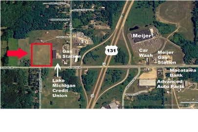
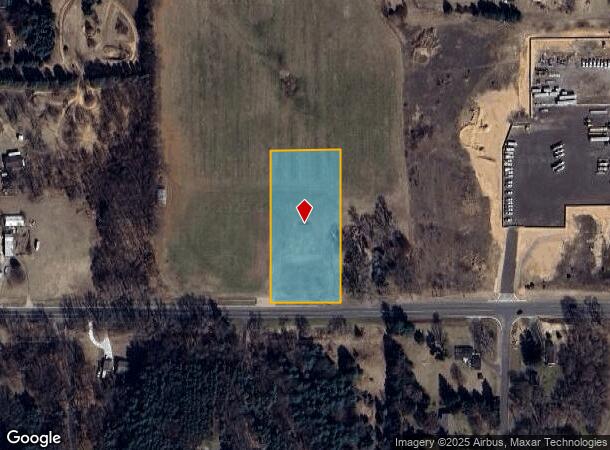
Property Record
2151 10 Mile Rd Ne, Comstock Park, MI 49321
NEARBY LISTINGS FOR SALE OR LEASE
-
-
View all Comstock Park listings for sale on LoopNet.com
Property Detail
2151 10 Mile Rd Ne
41-06-33-451-008
410633451008 S 468.61 FT OF W 200 FT OF E 1660.31 FT OF SE 1/4 * SEC 33 T9N R11W 2.15 A. SPLIT ON 04/23/2008 FROM
Residentialacreage
Kent
X
Michigan
26081C0301D
2 AC
2024
Outlying Kent County
2025
West Michigan
011405
Grand Rapids-Wyoming, MI
DEMOGRAPHICS near 2151 10 Mile Rd Ne
1 Mile
3 Mile
5 Mile
2024 Total Population
1,710
17,387
45,235
2029 Population
1,751
17,625
45,742
Pop Growth 2024-2029
+ 2.40%
+ 1.37%
+ 1.12%
Average Age
38
39
40
2024 Total Households
617
6,290
16,641
HH Growth 2024-2029
+ 2.59%
+ 1.37%
+ 1.11%
Median Household Inc
$99,544
$99,863
$94,083
Avg Household Size
2.70
2.70
2.70
2024 Avg HH Vehicles
2.00
2.00
2.00
Median Home Value
$329,430
$290,702
$280,766
Median Year Built
2006
1992
1989
Nearby Places
Map Layers
Map Styles
 Street
 Aerial
- Restaurants
- Banks
- Shops
- Fitness
- Groceries
PUBLIC TRANSPORTATION
AIRPORT
Gerald R Ford International
DRIVE
WALK
Distance
Gerald R Ford International
34 min
25.2 mi
Freight Ports
Port Milwaukee
DRIVE
WALK
Distance
Port Milwaukee
318 min
274.1 mi
Nearby Properties
Address
Land Use
TOTAL SIZE
Lot Size
Zoning
Address
Land Use
TOTAL SIZE
Lot Size
Zoning
32.53 AC
Address
Land Use
TOTAL SIZE
Lot Size
Zoning
22.40 AC
Address
Land Use
TOTAL SIZE
Lot Size
Zoning
128,148 SF
42.93 AC
PUD
Address
Land Use
TOTAL SIZE
Lot Size
Zoning
17.30 AC
Address
Land Use
TOTAL SIZE
Lot Size
Zoning
4.51 AC
Address
Land Use
TOTAL SIZE
Lot Size
Zoning
97.71 AC
Address
Land Use
TOTAL SIZE
Lot Size
Zoning
97.84 AC
Address
Land Use
TOTAL SIZE
Lot Size
Zoning
53.97 AC
Address
Land Use
TOTAL SIZE
Lot Size
Zoning
79.34 AC
Address
Land Use
TOTAL SIZE
Lot Size
Zoning
9.88 AC
Address
Land Use
TOTAL SIZE
Lot Size
Zoning
10.08 AC
Address
Land Use
TOTAL SIZE
Lot Size
Zoning
11.26 AC
Address
Land Use
TOTAL SIZE
Lot Size
Zoning
10.12 AC
Address
Land Use
TOTAL SIZE
Lot Size
Zoning
6.51 AC
Address
Land Use
TOTAL SIZE
Lot Size
Zoning
10.61 AC
Address
Land Use
TOTAL SIZE
Lot Size
Zoning
18,630 SF
1.84 AC
C2
Address
Land Use
TOTAL SIZE
Lot Size
Zoning
17.70 AC
Address
Land Use
TOTAL SIZE
Lot Size
Zoning
Address
Land Use
TOTAL SIZE
Lot Size
Zoning
2.28 AC
Address
Land Use
TOTAL SIZE
Lot Size
Zoning
3.62 AC
Address
Land Use
TOTAL SIZE
Lot Size
Zoning
257.69 AC
Address
Land Use
TOTAL SIZE
Lot Size
Zoning
2.96 AC
Address
Land Use
TOTAL SIZE
Lot Size
Zoning
Address
Land Use
TOTAL SIZE
Lot Size
Zoning
3.15 AC
Address
Land Use
TOTAL SIZE
Lot Size
Zoning
8.72 AC
Address
Land Use
TOTAL SIZE
Lot Size
Zoning
1,548 SF
49.71 AC
Address
Land Use
TOTAL SIZE
Lot Size
Zoning
1.34 AC
C-2
Address
Land Use
TOTAL SIZE
Lot Size
Zoning
5,445 SF
0.43 AC
C-2
Address
Land Use
TOTAL SIZE
Lot Size
Zoning
36,000 SF
11.97 AC
C2
Address
Land Use
TOTAL SIZE
Lot Size
Zoning
The World's #1 Commercial Real Estate Marketplace
Connect with us
© 2025 CoStar Group
The information above has been obtained from sources believed reliable. While we do not doubt its accuracy we have not verified it and make no guarantee, warranty or representation about it. It is your responsibility to independently confirm its accuracy and completeness. Any projections, opinions, assumptions, or estimates used are for example only and do not represent the current or future performance of the property. The value of this transaction to you depends on tax and other factors which should be evaluated by your tax, financial, and legal advisors. You and your advisors should conduct a careful, independent investigation of the property to determine to your satisfaction the suitability of the property for your needs.