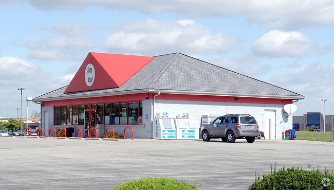
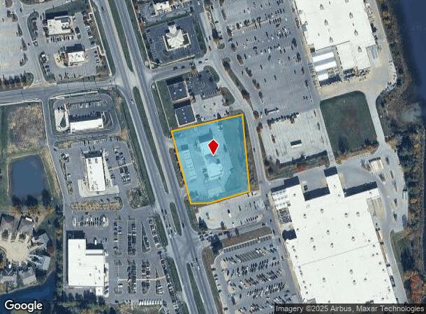
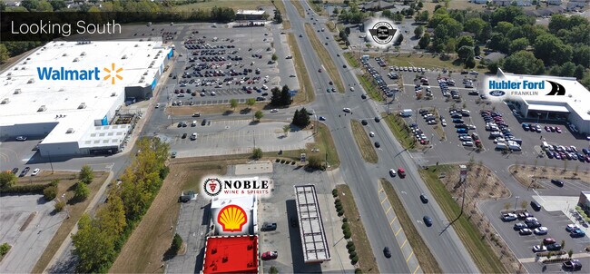
Property Record
2151 N Morton St, Franklin, IN 46131
NEARBY LISTINGS FOR SALE OR LEASE
Property Detail
2151 N Morton St
41-08-10-014-002.000-009
Franklin
Storebuilding
NE S10 T12 R4 MP FRANKLIN COMMUNI
X
Johnson
18081C0139E
Indiana
2024
2.22 AC
2025
Far South Johnson Cty
610802
Indianapolis
7,652 SF
Indianapolis-Carmel-Anderson, IN
DEMOGRAPHICS near 2151 N Morton St
1 Mile
3 Mile
5 Mile
2024 Total Population
7,186
29,598
43,322
2029 Population
7,656
31,715
46,357
Pop Growth 2024-2029
+ 6.54%
+ 7.15%
+ 7.01%
Average Age
37
39
39
2024 Total Households
2,788
10,879
15,858
HH Growth 2024-2029
+ 6.64%
+ 7.32%
+ 7.16%
Median Household Inc
$74,889
$71,077
$73,163
Avg Household Size
2.60
2.50
2.60
2024 Avg HH Vehicles
2.00
2.00
2.00
Median Home Value
$174,300
$185,450
$183,797
Median Year Built
1991
1992
1991
Nearby Places
Map Layers
Map Styles
 Street
 Aerial
- Restaurants
- Banks
- Shops
- Fitness
- Groceries
PUBLIC TRANSPORTATION
AIRPORT
Indianapolis International
DRIVE
WALK
Distance
Indianapolis International
47 min
28.7 mi
Freight Ports
Port of Toledo
DRIVE
WALK
Distance
Port of Toledo
296 min
244.0 mi
SALE & LEASE HISTORY
LISTING DATE
SALE/LEASE

Sep 30, 2024
For Lease
Jul 20, 2022
For Lease
Jul 20, 2022
For Lease
Nearby Properties
Address
Land Use
TOTAL SIZE
Lot Size
Zoning
Address
Land Use
TOTAL SIZE
Lot Size
Zoning
35,382 SF
42.11 AC
Address
Land Use
TOTAL SIZE
Lot Size
Zoning
34.59 AC
Address
Land Use
TOTAL SIZE
Lot Size
Zoning
588,200 SF
44.31 AC
Address
Land Use
TOTAL SIZE
Lot Size
Zoning
160.96 AC
PUD
Address
Land Use
TOTAL SIZE
Lot Size
Zoning
18.95 AC
Address
Land Use
TOTAL SIZE
Lot Size
Zoning
8,504 SF
31.42 AC
Address
Land Use
TOTAL SIZE
Lot Size
Zoning
1,792 SF
66.50 AC
Address
Land Use
TOTAL SIZE
Lot Size
Zoning
232,709 SF
51.30 AC
Address
Land Use
TOTAL SIZE
Lot Size
Zoning
193,378 SF
20.55 AC
Address
Land Use
TOTAL SIZE
Lot Size
Zoning
7,304 SF
15.32 AC
Address
Land Use
TOTAL SIZE
Lot Size
Zoning
136,760 SF
31.47 AC
Address
Land Use
TOTAL SIZE
Lot Size
Zoning
119,499 SF
11.54 AC
Address
Land Use
TOTAL SIZE
Lot Size
Zoning
54,436 SF
18.83 AC
Address
Land Use
TOTAL SIZE
Lot Size
Zoning
207,310 SF
17.20 AC
Address
Land Use
TOTAL SIZE
Lot Size
Zoning
20.19 AC
Address
Land Use
TOTAL SIZE
Lot Size
Zoning
86,082 SF
8.14 AC
Address
Land Use
TOTAL SIZE
Lot Size
Zoning
2,516 SF
7.87 AC
Address
Land Use
TOTAL SIZE
Lot Size
Zoning
2,304 SF
14.05 AC
Address
Land Use
TOTAL SIZE
Lot Size
Zoning
119,416 SF
11.51 AC
Address
Land Use
TOTAL SIZE
Lot Size
Zoning
26,208 SF
3.74 AC
PUD
Address
Land Use
TOTAL SIZE
Lot Size
Zoning
539,190 SF
33.27 AC
Address
Land Use
TOTAL SIZE
Lot Size
Zoning
39.94 AC
PUD
Address
Land Use
TOTAL SIZE
Lot Size
Zoning
160,700 SF
25.56 AC
Address
Land Use
TOTAL SIZE
Lot Size
Zoning
140,328 SF
20 AC
Address
Land Use
TOTAL SIZE
Lot Size
Zoning
290,449 SF
22.82 AC
Address
Land Use
TOTAL SIZE
Lot Size
Zoning
8,428 SF
7.39 AC
Address
Land Use
TOTAL SIZE
Lot Size
Zoning
68,423 SF
41.73 AC
Address
Land Use
TOTAL SIZE
Lot Size
Zoning
100,672 SF
25.32 AC
Address
Land Use
TOTAL SIZE
Lot Size
Zoning
133,820 SF
32.60 AC
Address
Land Use
TOTAL SIZE
Lot Size
Zoning
100,099 SF
9.37 AC
The World's #1 Commercial Real Estate Marketplace
Connect with us
© 2025 CoStar Group
The information above has been obtained from sources believed reliable. While we do not doubt its accuracy we have not verified it and make no guarantee, warranty or representation about it. It is your responsibility to independently confirm its accuracy and completeness. Any projections, opinions, assumptions, or estimates used are for example only and do not represent the current or future performance of the property. The value of this transaction to you depends on tax and other factors which should be evaluated by your tax, financial, and legal advisors. You and your advisors should conduct a careful, independent investigation of the property to determine to your satisfaction the suitability of the property for your needs.