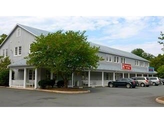
Property Record
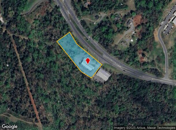
2151 Richmond Rd, Charlottesville, VA 22911
NEARBY LISTINGS FOR SALE OR LEASE
Property Detail
2151 Richmond Rd
07800-00-00-033A0
PARCEL X
Storebuilding
Albemarle
X
Virginia
51003C0295D
2.02 AC
2025
Charlottesville
2025
Other Market Areas
010502
Charlottesville, VA
10,240 SF
DEMOGRAPHICS near 2151 Richmond Rd
1 mile
3 mile
5 mile
2024 Total Population
487
17,765
70,615
2029 Population
511
17,863
70,626
Pop Growth 2024-2029
+ 4.93%
+ 0.55%
+ 0.02%
Average Age
46
43
38
2024 Total Households
224
8,361
29,405
HH Growth 2024-2029
+ 5.36%
+ 0.67%
+ 0.18%
Median Household Inc
$132,974
$89,158
$78,596
Avg Household Size
2.10
2.10
2.20
2024 Avg HH Vehicles
2.00
2.00
2.00
Median Home Value
$454,761
$441,145
$427,580
Median Year Built
2009
1992
1984
Nearby Places
Map Layers
Map Styles
 Street
 Aerial
Transit
 Traffic
 Biking
Places
Listings with unknown addresses are not visible on the map
- Restaurants
- Banks
- Shops
- Fitness
- Groceries
PUBLIC TRANSPORTATION
COMMUTER RAIL
Charlottesville (Cardinal - Amtrak, Crescent - Amtrak, Northeast Regional - Amtrak)
Drive
Walk
Distance
Charlottesville (Cardinal - Amtrak, Crescent - Amtrak, Northeast Regional - Amtrak)
10 min
5.0 mi
AIRPORT
Charlottesville-Albemarle
Drive
Walk
Distance
Charlottesville-Albemarle
25 min
12.2 mi
Freight Ports
Virginia Port Authority - Richmond
Drive
Walk
Distance
Virginia Port Authority - Richmond
87 min
73.7 mi
Nearby Properties
Address
Land Use
TOTAL SIZE
Lot Size
Zoning
Address
Land Use
TOTAL SIZE
Lot Size
Zoning
429,500 SF
38.49 AC
PDMC
Address
Land Use
TOTAL SIZE
Lot Size
Zoning
160,621 SF
55.78 AC
PLANNED RE
Address
Land Use
TOTAL SIZE
Lot Size
Zoning
3,803 SF
266.70 AC
CV
Address
Land Use
TOTAL SIZE
Lot Size
Zoning
14,000 SF
6.45 AC
CX-5
Address
Land Use
TOTAL SIZE
Lot Size
Zoning
336,000 SF
20.20 AC
R15 RESIDE
Address
Land Use
TOTAL SIZE
Lot Size
Zoning
20.41 AC
Address
Land Use
TOTAL SIZE
Lot Size
Zoning
222,253 SF
0.73 AC
NX-10
Address
Land Use
TOTAL SIZE
Lot Size
Zoning
42,336 SF
0.90 AC
CV
Address
Land Use
TOTAL SIZE
Lot Size
Zoning
12,495 SF
4.50 AC
NX-10
Address
Land Use
TOTAL SIZE
Lot Size
Zoning
223,492 SF
35 AC
COMMERCIAL
Address
Land Use
TOTAL SIZE
Lot Size
Zoning
73,068 SF
13.39 AC
PLANNED DE
Address
Land Use
TOTAL SIZE
Lot Size
Zoning
100 SF
51.71 AC
LIGHT INDU
Address
Land Use
TOTAL SIZE
Lot Size
Zoning
176,364 SF
9.71 AC
R15 RESIDE
Address
Land Use
TOTAL SIZE
Lot Size
Zoning
1,195,052 SF
1.05 AC
DX
Address
Land Use
TOTAL SIZE
Lot Size
Zoning
75,760 SF
1.15 AC
CV
Address
Land Use
TOTAL SIZE
Lot Size
Zoning
128,620 SF
3.06 AC
CX-8
Address
Land Use
TOTAL SIZE
Lot Size
Zoning
85,000 SF
3.49 AC
NX-10
Address
Land Use
TOTAL SIZE
Lot Size
Zoning
81,569 SF
0.63 AC
DX
Address
Land Use
TOTAL SIZE
Lot Size
Zoning
28,392 SF
10.38 AC
C1 COMMERC
Address
Land Use
TOTAL SIZE
Lot Size
Zoning
150,768 SF
14.40 AC
R10 RESIDE
Address
Land Use
TOTAL SIZE
Lot Size
Zoning
77,112 SF
4.10 AC
PLANNED DE
Address
Land Use
TOTAL SIZE
Lot Size
Zoning
92,044 SF
15.70 AC
R-A
Address
Land Use
TOTAL SIZE
Lot Size
Zoning
101,938 SF
2.94 AC
R15 RESIDE
Address
Land Use
TOTAL SIZE
Lot Size
Zoning
2,000 SF
13.91 AC
LIGHT INDU
Address
Land Use
TOTAL SIZE
Lot Size
Zoning
5,773 SF
684.60 AC
RURAL AREA
Address
Land Use
TOTAL SIZE
Lot Size
Zoning
54,090 SF
11.10 AC
PDMC
Address
Land Use
TOTAL SIZE
Lot Size
Zoning
2.88 AC
HIGHWAY CO
Address
Land Use
TOTAL SIZE
Lot Size
Zoning
74,900 SF
7.42 AC
PLANNED DE
Address
Land Use
TOTAL SIZE
Lot Size
Zoning
84,156 SF
7.90 AC
PLANNED DE
Address
Land Use
TOTAL SIZE
Lot Size
Zoning
70,740 SF
8.01 AC
PLANNED DE
The World's #1 Commercial Real Estate Marketplace
Connect with us
© 2026 CoStar Group
The information above has been obtained from sources believed reliable. While we do not doubt its accuracy we have not verified it and make no guarantee, warranty or representation about it. It is your responsibility to independently confirm its accuracy and completeness. Any projections, opinions, assumptions, or estimates used are for example only and do not represent the current or future performance of the property. The value of this transaction to you depends on tax and other factors which should be evaluated by your tax, financial, and legal advisors. You and your advisors should conduct a careful, independent investigation of the property to determine to your satisfaction the suitability of the property for your needs.