Property Record
2151 W 143Rd St, Dixmoor, IL 60426
NEARBY LISTINGS FOR SALE OR LEASE
Property Detail
2151 W 143Rd St
29-07-118-002-0000
Cook
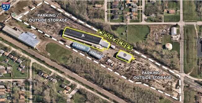
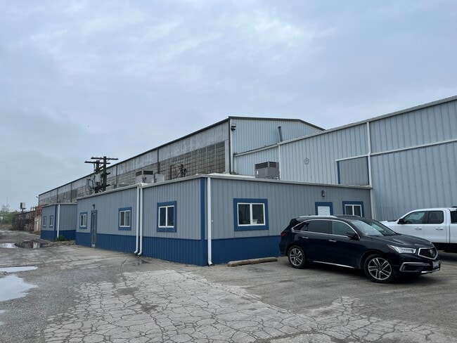
Railroadfacility
Illinois
X
0.58 AC
17031C0643J
Near South Cook
0
Chicago
2024
Chicago-Naperville-Elgin, IL-IN-WI
827300
DEMOGRAPHICS near 2151 W 143Rd St
1 Mile
3 Mile
5 Mile
2024 Total Population
11,799
109,840
301,183
2029 Population
11,820
109,025
295,871
Pop Growth 2024-2029
+ 0.18%
(0.74%)
(1.76%)
Average Age
37
39
40
2024 Total Households
3,984
39,243
110,947
HH Growth 2024-2029
+ 0.05%
(0.98%)
(2.06%)
Median Household Inc
$42,524
$43,663
$54,156
Avg Household Size
2.90
2.70
2.60
2024 Avg HH Vehicles
2.00
2.00
2.00
Median Home Value
$97,756
$118,408
$152,698
Median Year Built
1967
1960
1962
Nearby Places
Map Layers
Map Styles
 Street
 Aerial
- Restaurants
- Banks
- Shops
- Fitness
- Groceries
PUBLIC TRANSPORTATION
COMMUTER RAIL
147Th St. (Metra Electric - Metra)
DRIVE
WALK
Distance
147Th St. (Metra Electric - Metra)
5 min
2.0 mi
Robbins Station (Rock Island District Line - Northeast Illinois Regional Commuter Railroad (Metra))
DRIVE
WALK
Distance
Robbins Station (Rock Island District Line - Northeast Illinois Regional Commuter Railroad (Metra))
8 min
3.1 mi
AIRPORT
Chicago Midway International
DRIVE
WALK
Distance
Chicago Midway International
26 min
15.4 mi
Chicago O'Hare International
DRIVE
WALK
Distance
Chicago O'Hare International
51 min
37.1 mi
Freight Ports
Port Milwaukee
DRIVE
WALK
Distance
Port Milwaukee
132 min
108.9 mi
SALE & LEASE HISTORY
LISTING DATE
SALE/LEASE

Sep 13, 2024
For Sale
Jan 11, 2021
For Sale
Aug 10, 2023
For Lease
Nearby Properties
Address
Land Use
TOTAL SIZE
Lot Size
Zoning
Address
Land Use
TOTAL SIZE
Lot Size
Zoning
1.45 AC
Address
Land Use
TOTAL SIZE
Lot Size
Zoning
Address
Land Use
TOTAL SIZE
Lot Size
Zoning
83,005 SF
3.11 AC
Address
Land Use
TOTAL SIZE
Lot Size
Zoning
380,924 SF
19.13 AC
Address
Land Use
TOTAL SIZE
Lot Size
Zoning
Address
Land Use
TOTAL SIZE
Lot Size
Zoning
Address
Land Use
TOTAL SIZE
Lot Size
Zoning
162,379 SF
10.59 AC
Address
Land Use
TOTAL SIZE
Lot Size
Zoning
Address
Land Use
TOTAL SIZE
Lot Size
Zoning
8,800 SF
8.83 AC
Address
Land Use
TOTAL SIZE
Lot Size
Zoning
49,229 SF
1.31 AC
Address
Land Use
TOTAL SIZE
Lot Size
Zoning
132,322 SF
2 AC
Address
Land Use
TOTAL SIZE
Lot Size
Zoning
Address
Land Use
TOTAL SIZE
Lot Size
Zoning
38,111 SF
6.70 AC
Address
Land Use
TOTAL SIZE
Lot Size
Zoning
13,327 SF
64.93 AC
Address
Land Use
TOTAL SIZE
Lot Size
Zoning
513,843 SF
23.76 AC
Address
Land Use
TOTAL SIZE
Lot Size
Zoning
170,680 SF
15.28 AC
M3-3
Address
Land Use
TOTAL SIZE
Lot Size
Zoning
180,139 SF
18.78 AC
Address
Land Use
TOTAL SIZE
Lot Size
Zoning
20,579 SF
1.14 AC
Address
Land Use
TOTAL SIZE
Lot Size
Zoning
80,025 SF
0.70 AC
Address
Land Use
TOTAL SIZE
Lot Size
Zoning
Address
Land Use
TOTAL SIZE
Lot Size
Zoning
Address
Land Use
TOTAL SIZE
Lot Size
Zoning
4,506 SF
2.27 AC
Address
Land Use
TOTAL SIZE
Lot Size
Zoning
456 SF
0.39 AC
Address
Land Use
TOTAL SIZE
Lot Size
Zoning
28.54 AC
Address
Land Use
TOTAL SIZE
Lot Size
Zoning
12.38 AC
Address
Land Use
TOTAL SIZE
Lot Size
Zoning
8,644 SF
0.26 AC
Address
Land Use
TOTAL SIZE
Lot Size
Zoning
55,000 SF
2.34 AC
Address
Land Use
TOTAL SIZE
Lot Size
Zoning
2,320 SF
18 AC
Address
Land Use
TOTAL SIZE
Lot Size
Zoning
8.75 AC
The World's #1 Commercial Real Estate Marketplace
Connect with us
© 2025 CoStar Group
The information above has been obtained from sources believed reliable. While we do not doubt its accuracy we have not verified it and make no guarantee, warranty or representation about it. It is your responsibility to independently confirm its accuracy and completeness. Any projections, opinions, assumptions, or estimates used are for example only and do not represent the current or future performance of the property. The value of this transaction to you depends on tax and other factors which should be evaluated by your tax, financial, and legal advisors. You and your advisors should conduct a careful, independent investigation of the property to determine to your satisfaction the suitability of the property for your needs.