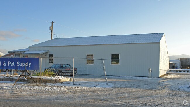
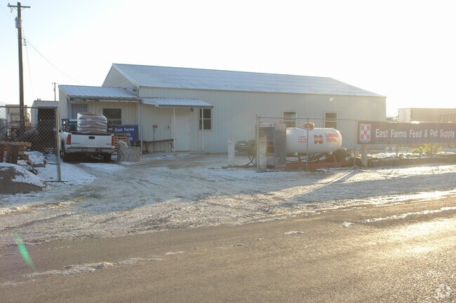
Property Record
21518 E Gilbert Ave, Otis Orchards, WA 99027
Save to a Folder
{{folder.Name}}
{{folder.ListingIds.length}} Properties
{{folder.ListingIds.length}} Property
Create a New Folder
Property Detail
21518 E Gilbert Ave
56334.9050
33-26-45: THAT PORTION OF THE SOUTHEAST QUARTER OF SAID SECTION 33 BEING MORE PARTICULARLY DESCRIBED AS FOLLOWS: THE NORTH 115 FEET OF THE SOUTH 394 FEET OF THE WEST 185 FEET OF THE EAST 320 FEET OF THE NORTHWEST QUARTER OF THE NORTHEAST QUARTER OF T
Storebuilding
Spokane
LI
Washington
B and X Area of moderate flood hazard, usually the area between the limits of the 100-year and 500-year floods.
0.53 AC
2026
Valley
2026
Spokane
013201
Spokane-Spokane Valley, WA
970 SF
NEARBY LISTINGS FOR SALE OR LEASE
DEMOGRAPHICS near 21518 E Gilbert Ave
1 mile
3 mile
5 mile
2025 Total Population
2,072
19,587
53,935
2030 Population
2,078
20,054
55,744
Pop Growth 2025-2030
+ 0.29%
+ 2.38%
+ 3.35%
Average Age
44
43
41
2025 Total Households
793
7,701
21,051
HH Growth 2025-2030
+ 0.38%
+ 2.42%
+ 3.37%
Median Household Inc
$82,267
$85,833
$86,991
Avg Household Size
2.60
2.50
2.50
2025 Avg HH Vehicles
3.00
2.00
2.00
Median Home Value
$424,074
$468,338
$476,756
Median Year Built
1979
1994
1997
Nearby Places
Map Layers
Map Styles
 Street
 Aerial
Layers
 Traffic
 Biking
Places
Listings with unknown addresses are not visible on the map
- Restaurants
- Banks
- Shops
- Fitness
- Groceries
PUBLIC TRANSPORTATION
AIRPORT
Spokane International
Drive
Walk
Distance
Spokane International
33 min
21.9 mi
Freight Ports
Port of Everett
Drive
Walk
Distance
Port of Everett
361 min
317.5 mi
Nearby Properties
Address
Land Use
TOTAL SIZE
Lot Size
Zoning
Address
Land Use
TOTAL SIZE
Lot Size
Zoning
1,077,082 SF
85.91 AC
I-2
Address
Land Use
TOTAL SIZE
Lot Size
Zoning
296,760 SF
37.61 AC
I-1
Address
Land Use
TOTAL SIZE
Lot Size
Zoning
602,024 SF
44.20 AC
I
Address
Land Use
TOTAL SIZE
Lot Size
Zoning
358,700 SF
16.41 AC
R3
Address
Land Use
TOTAL SIZE
Lot Size
Zoning
112,242 SF
13.94 AC
SAP
Address
Land Use
TOTAL SIZE
Lot Size
Zoning
132,986 SF
10.93 AC
M2
Address
Land Use
TOTAL SIZE
Lot Size
Zoning
192,384 SF
9.63 AC
I-2
Address
Land Use
TOTAL SIZE
Lot Size
Zoning
150,936 SF
9.30 AC
M2
Address
Land Use
TOTAL SIZE
Lot Size
Zoning
144,544 SF
9.65 AC
I-1
Address
Land Use
TOTAL SIZE
Lot Size
Zoning
145,884 SF
6.87 AC
M2
Address
Land Use
TOTAL SIZE
Lot Size
Zoning
78,795 SF
39.53 AC
C2
Address
Land Use
TOTAL SIZE
Lot Size
Zoning
144,349 SF
8.06 AC
I-2
Address
Land Use
TOTAL SIZE
Lot Size
Zoning
105,457 SF
9.69 AC
SAP
Address
Land Use
TOTAL SIZE
Lot Size
Zoning
233,763 SF
9.63 AC
I
Address
Land Use
TOTAL SIZE
Lot Size
Zoning
84,317 SF
9.27 AC
I
Address
Land Use
TOTAL SIZE
Lot Size
Zoning
104,962 SF
4.86 AC
Address
Land Use
TOTAL SIZE
Lot Size
Zoning
154,265 SF
13.38 AC
I
Address
Land Use
TOTAL SIZE
Lot Size
Zoning
201,370 SF
21.72 AC
I
Address
Land Use
TOTAL SIZE
Lot Size
Zoning
136,894 SF
8.20 AC
I-2
Address
Land Use
TOTAL SIZE
Lot Size
Zoning
131,648 SF
11.02 AC
Address
Land Use
TOTAL SIZE
Lot Size
Zoning
184,710 SF
13.12 AC
I
Address
Land Use
TOTAL SIZE
Lot Size
Zoning
140,395 SF
10.44 AC
I
Address
Land Use
TOTAL SIZE
Lot Size
Zoning
296,341 SF
23.08 AC
I
Address
Land Use
TOTAL SIZE
Lot Size
Zoning
33,709 SF
8.02 AC
I-1
Address
Land Use
TOTAL SIZE
Lot Size
Zoning
102,529 SF
13.98 AC
M2
Address
Land Use
TOTAL SIZE
Lot Size
Zoning
33,288 SF
5.53 AC
Address
Land Use
TOTAL SIZE
Lot Size
Zoning
105,600 SF
7.50 AC
I-2
Address
Land Use
TOTAL SIZE
Lot Size
Zoning
63,044 SF
5.80 AC
I
Address
Land Use
TOTAL SIZE
Lot Size
Zoning
63,044 SF
7.98 AC
I
Address
Land Use
TOTAL SIZE
Lot Size
Zoning
80,744 SF
8.11 AC
I
The World's #1 Commercial Real Estate Marketplace
Connect with us
© 2026 CoStar Group
The information above has been obtained from sources believed reliable. While we do not doubt its accuracy we have not verified it and make no guarantee, warranty or representation about it. It is your responsibility to independently confirm its accuracy and completeness. Any projections, opinions, assumptions, or estimates used are for example only and do not represent the current or future performance of the property. The value of this transaction to you depends on tax and other factors which should be evaluated by your tax, financial, and legal advisors. You and your advisors should conduct a careful, independent investigation of the property to determine to your satisfaction the suitability of the property for your needs.