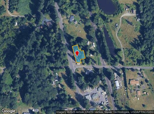
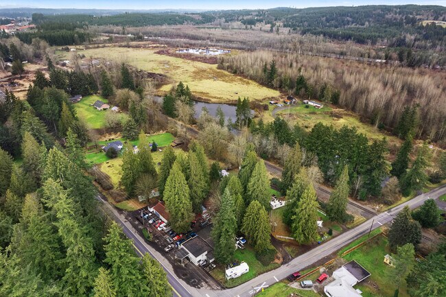
Property Record
21530 Old Highway 99 Sw, Centralia, WA 98531

NEARBY LISTINGS FOR SALE OR LEASE
Property Detail
21530 Old Highway 99 Sw
13524210500
SECTION 24 TOWNSHIP 15 RANGE 3W QUARTER NE NW COM X N LN HOBSON RD & ELY LN OLD PACIFIC HW NWLY ALG E LN 186F, NELY RIGHT ANG 60F SELY PARALLEL E LN 49F NELY RIGHT ANG 17F, SELY PARALLEL E LN 25F,
Supermarket
Thurston
X
Washington
53067C0445F
0.35 AC
2024
Outlying Thurston County
2024
Olympia
012720
Olympia-Tumwater, WA
2,144 SF
DEMOGRAPHICS near 21530 Old Highway 99 Sw
1 Mile
3 Mile
5 Mile
2024 Total Population
667
7,301
34,454
2029 Population
711
7,854
37,830
Pop Growth 2024-2029
+ 6.60%
+ 7.57%
+ 9.80%
Average Age
41
40
41
2024 Total Households
241
2,669
12,951
HH Growth 2024-2029
+ 6.64%
+ 7.79%
+ 10.01%
Median Household Inc
$99,739
$76,588
$63,941
Avg Household Size
2.70
2.70
2.60
2024 Avg HH Vehicles
3.00
2.00
2.00
Median Home Value
$555,555
$343,552
$330,300
Median Year Built
1994
1991
1986
Nearby Places
Map Layers
Map Styles
 Street
 Aerial
- Restaurants
- Banks
- Shops
- Fitness
- Groceries
PUBLIC TRANSPORTATION
COMMUTER RAIL
Centralia Amtrak Station (Amtrak Cascades - Amtrak, Coast Starlight - Amtrak)
DRIVE
WALK
Distance
Centralia Amtrak Station (Amtrak Cascades - Amtrak, Coast Starlight - Amtrak)
11 min
5.3 mi
Freight Ports
Port of Grays Harbor, WA
DRIVE
WALK
Distance
Port of Grays Harbor, WA
75 min
49.7 mi
SALE & LEASE HISTORY
LISTING DATE
SALE/LEASE

Feb 07, 2025
For Sale
Nearby Properties
Address
Land Use
TOTAL SIZE
Lot Size
Zoning
Address
Land Use
TOTAL SIZE
Lot Size
Zoning
1,038,447 SF
77 AC
PMP
Address
Land Use
TOTAL SIZE
Lot Size
Zoning
441,608 SF
Address
Land Use
TOTAL SIZE
Lot Size
Zoning
32,914 SF
3.38 AC
PMP
Address
Land Use
TOTAL SIZE
Lot Size
Zoning
229,011 SF
209.52 AC
PID
Address
Land Use
TOTAL SIZE
Lot Size
Zoning
155,458 SF
15.79 AC
PMP
Address
Land Use
TOTAL SIZE
Lot Size
Zoning
738,962 SF
16.50 AC
Address
Land Use
TOTAL SIZE
Lot Size
Zoning
297,970 SF
19.32 AC
PID
Address
Land Use
TOTAL SIZE
Lot Size
Zoning
158,948 SF
77.13 AC
RRR1/5
Address
Land Use
TOTAL SIZE
Lot Size
Zoning
1,427 SF
15.22 AC
Address
Land Use
TOTAL SIZE
Lot Size
Zoning
129,242 SF
11.91 AC
M1
Address
Land Use
TOTAL SIZE
Lot Size
Zoning
14,264 SF
6.60 AC
R20
Address
Land Use
TOTAL SIZE
Lot Size
Zoning
196,060 SF
24.68 AC
PMP
Address
Land Use
TOTAL SIZE
Lot Size
Zoning
7,200 SF
4 AC
OSPF
Address
Land Use
TOTAL SIZE
Lot Size
Zoning
28,522 SF
2 AC
M2
Address
Land Use
TOTAL SIZE
Lot Size
Zoning
75,993 SF
18.76 AC
PMP
Address
Land Use
TOTAL SIZE
Lot Size
Zoning
Address
Land Use
TOTAL SIZE
Lot Size
Zoning
940 SF
1.50 AC
Address
Land Use
TOTAL SIZE
Lot Size
Zoning
4,104 SF
79.55 AC
M2
Address
Land Use
TOTAL SIZE
Lot Size
Zoning
7.13 AC
Address
Land Use
TOTAL SIZE
Lot Size
Zoning
23,908 SF
3.74 AC
AC
Address
Land Use
TOTAL SIZE
Lot Size
Zoning
3,096 SF
4.89 AC
M1
Address
Land Use
TOTAL SIZE
Lot Size
Zoning
72.49 AC
PMP
Address
Land Use
TOTAL SIZE
Lot Size
Zoning
22.44 AC
PMP
Address
Land Use
TOTAL SIZE
Lot Size
Zoning
768 SF
34.16 AC
PID
Address
Land Use
TOTAL SIZE
Lot Size
Zoning
19,626 SF
2.35 AC
PMP
Address
Land Use
TOTAL SIZE
Lot Size
Zoning
1,728 SF
13.88 AC
RDD5
Address
Land Use
TOTAL SIZE
Lot Size
Zoning
4,000 SF
8.41 AC
M2
Address
Land Use
TOTAL SIZE
Lot Size
Zoning
2,838 SF
33.09 AC
M2
Address
Land Use
TOTAL SIZE
Lot Size
Zoning
12,616 SF
7.56 AC
AC
Address
Land Use
TOTAL SIZE
Lot Size
Zoning
28,248 SF
4.92 AC
PID
The World's #1 Commercial Real Estate Marketplace
Connect with us
© 2025 CoStar Group
The information above has been obtained from sources believed reliable. While we do not doubt its accuracy we have not verified it and make no guarantee, warranty or representation about it. It is your responsibility to independently confirm its accuracy and completeness. Any projections, opinions, assumptions, or estimates used are for example only and do not represent the current or future performance of the property. The value of this transaction to you depends on tax and other factors which should be evaluated by your tax, financial, and legal advisors. You and your advisors should conduct a careful, independent investigation of the property to determine to your satisfaction the suitability of the property for your needs.