Property Record
2155 Fields Blvd, Greenfield, IN 46140
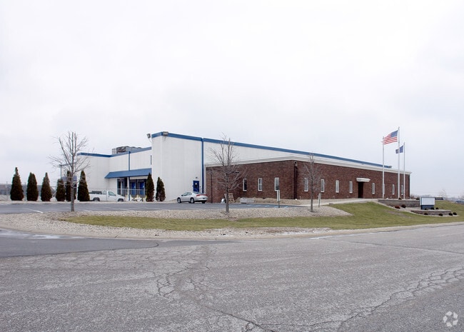


Property Detail
2155 Fields Blvd
30-07-20-400-001.000-009
GFLD AT THE XING S1 L1 SE 20-16-7 6.428
Warehouse
Hancock
B and X Area of moderate flood hazard, usually the area between the limits of the 100-year and 500-year floods.
Indiana
2025
6.43 AC
2025
Hancock County
410301
Indianapolis
52,551 SF
Indianapolis-Carmel-Greenwood, IN
NEARBY LISTINGS FOR SALE OR LEASE
DEMOGRAPHICS near 2155 Fields Blvd
1 mile
3 mile
5 mile
2025 Total Population
3,626
27,938
36,049
2030 Population
3,939
30,729
39,608
Pop Growth 2025-2030
+ 8.63%
+ 9.99%
+ 9.87%
Average Age
41
41
41
2025 Total Households
1,507
11,386
14,580
HH Growth 2025-2030
+ 8.96%
+ 10.27%
+ 10.15%
Median Household Inc
$77,566
$79,225
$81,198
Avg Household Size
2.30
2.40
2.40
2025 Avg HH Vehicles
2.00
2.00
2.00
Median Home Value
$247,451
$227,423
$240,209
Median Year Built
1989
1994
1993
Nearby Places
Map Layers
Map Styles
 Street
 Aerial
Layers
 Traffic
 Biking
Places
Listings with unknown addresses are not visible on the map
- Restaurants
- Banks
- Shops
- Fitness
- Groceries
PUBLIC TRANSPORTATION
AIRPORT
Indianapolis International
Drive
Walk
Distance
Indianapolis International
55 min
37.2 mi
Freight Ports
Port of Toledo
Drive
Walk
Distance
Port of Toledo
254 min
207.9 mi
Nearby Properties
Address
Land Use
TOTAL SIZE
Lot Size
Zoning
Address
Land Use
TOTAL SIZE
Lot Size
Zoning
505,100 SF
22.47 AC
Address
Land Use
TOTAL SIZE
Lot Size
Zoning
1,001,373 SF
81.13 AC
Address
Land Use
TOTAL SIZE
Lot Size
Zoning
294,173 SF
38.43 AC
Address
Land Use
TOTAL SIZE
Lot Size
Zoning
13,428 SF
23 AC
Address
Land Use
TOTAL SIZE
Lot Size
Zoning
26,680 SF
20.64 AC
Address
Land Use
TOTAL SIZE
Lot Size
Zoning
17,606 SF
21.29 AC
Address
Land Use
TOTAL SIZE
Lot Size
Zoning
704 SF
40.64 AC
Address
Land Use
TOTAL SIZE
Lot Size
Zoning
14,120 SF
21.75 AC
Address
Land Use
TOTAL SIZE
Lot Size
Zoning
2,730 SF
21.24 AC
Address
Land Use
TOTAL SIZE
Lot Size
Zoning
Address
Land Use
TOTAL SIZE
Lot Size
Zoning
9,522 SF
19.74 AC
Address
Land Use
TOTAL SIZE
Lot Size
Zoning
423,054 SF
113.86 AC
Address
Land Use
TOTAL SIZE
Lot Size
Zoning
84,364 SF
28.27 AC
Address
Land Use
TOTAL SIZE
Lot Size
Zoning
243,574 SF
19.92 AC
Address
Land Use
TOTAL SIZE
Lot Size
Zoning
96,349 SF
10.55 AC
Address
Land Use
TOTAL SIZE
Lot Size
Zoning
49,600 SF
4.27 AC
Address
Land Use
TOTAL SIZE
Lot Size
Zoning
219,354 SF
9.95 AC
Address
Land Use
TOTAL SIZE
Lot Size
Zoning
184,512 SF
Address
Land Use
TOTAL SIZE
Lot Size
Zoning
185,826 SF
20.54 AC
Address
Land Use
TOTAL SIZE
Lot Size
Zoning
229,786 SF
16 AC
Address
Land Use
TOTAL SIZE
Lot Size
Zoning
70,256 SF
1.13 AC
Address
Land Use
TOTAL SIZE
Lot Size
Zoning
195,134 SF
Address
Land Use
TOTAL SIZE
Lot Size
Zoning
52,809 SF
6.52 AC
Address
Land Use
TOTAL SIZE
Lot Size
Zoning
87,810 SF
10.45 AC
Address
Land Use
TOTAL SIZE
Lot Size
Zoning
115,758 SF
7.10 AC
Address
Land Use
TOTAL SIZE
Lot Size
Zoning
72,791 SF
9.52 AC
Address
Land Use
TOTAL SIZE
Lot Size
Zoning
43,012 SF
2.02 AC
Address
Land Use
TOTAL SIZE
Lot Size
Zoning
46,690 SF
2.08 AC
Address
Land Use
TOTAL SIZE
Lot Size
Zoning
46,680 SF
1.96 AC
Address
Land Use
TOTAL SIZE
Lot Size
Zoning
88,200 SF
10.86 AC
The World's #1 Commercial Real Estate Marketplace
Connect with us
© 2026 CoStar Group
The information above has been obtained from sources believed reliable. While we do not doubt its accuracy we have not verified it and make no guarantee, warranty or representation about it. It is your responsibility to independently confirm its accuracy and completeness. Any projections, opinions, assumptions, or estimates used are for example only and do not represent the current or future performance of the property. The value of this transaction to you depends on tax and other factors which should be evaluated by your tax, financial, and legal advisors. You and your advisors should conduct a careful, independent investigation of the property to determine to your satisfaction the suitability of the property for your needs.