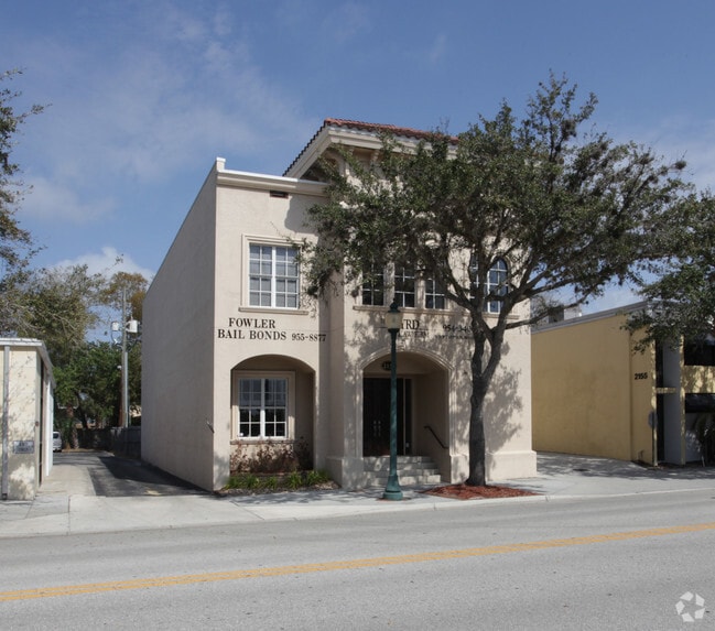
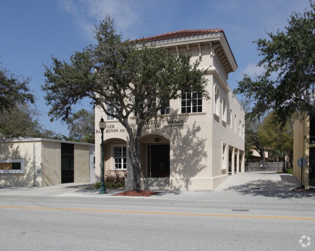
Property Record
2151 Main St, Sarasota, FL 34237


Property Detail
2151 Main St
2029-04-0018
BEG AT SE COR OF W 1/2 OF LOT 18, BLK L, PLAT OF SARASOTA, TH N 150 FT TH W 50 FT TH S 150 FT TH E 50 FT TO POB
Officebuilding
Sarasota
DTC
Florida
B and X Area of moderate flood hazard, usually the area between the limits of the 100-year and 500-year floods.
18
2024
0.17 AC
2025
Sarasota
000102
Tampa/St Petersburg
4,078 SF
North Port-Bradenton-Sarasota, FL
NEARBY LISTINGS FOR SALE OR LEASE
DEMOGRAPHICS near 2151 Main St
1 mile
3 mile
5 mile
2025 Total Population
15,320
82,362
174,660
2030 Population
16,458
87,558
186,525
Pop Growth 2025-2030
+ 7.43%
+ 6.31%
+ 6.79%
Average Age
46
46
48
2025 Total Households
7,304
37,203
79,858
HH Growth 2025-2030
+ 7.50%
+ 6.42%
+ 6.99%
Median Household Inc
$68,865
$69,617
$76,337
Avg Household Size
1.90
2.10
2.10
2025 Avg HH Vehicles
1.00
2.00
2.00
Median Home Value
$638,689
$430,353
$454,930
Median Year Built
1979
1976
1980
Nearby Places
Map Layers
Map Styles
 Street
 Aerial
Layers
 Traffic
 Biking
Places
Listings with unknown addresses are not visible on the map
- Restaurants
- Banks
- Shops
- Fitness
- Groceries
PUBLIC TRANSPORTATION
AIRPORT
Sarasota/Bradenton International
Drive
Walk
Distance
Sarasota/Bradenton International
12 min
5.6 mi
Freight Ports
Port Manatee
Drive
Walk
Distance
Port Manatee
39 min
23.5 mi
Nearby Properties
Address
Land Use
TOTAL SIZE
Lot Size
Zoning
Address
Land Use
TOTAL SIZE
Lot Size
Zoning
2,010,667 SF
14.38 AC
SMH
Address
Land Use
TOTAL SIZE
Lot Size
Zoning
843,350 SF
5.13 AC
DTC
Address
Land Use
TOTAL SIZE
Lot Size
Zoning
124,840 SF
29.18 AC
G
Address
Land Use
TOTAL SIZE
Lot Size
Zoning
516,332 SF
7.62 AC
DTB
Address
Land Use
TOTAL SIZE
Lot Size
Zoning
439,798 SF
4.20 AC
DTC
Address
Land Use
TOTAL SIZE
Lot Size
Zoning
595,734 SF
1.63 AC
DTB
Address
Land Use
TOTAL SIZE
Lot Size
Zoning
595,368 SF
13.76 AC
MCI
Address
Land Use
TOTAL SIZE
Lot Size
Zoning
458,955 SF
3.99 AC
DTE
Address
Land Use
TOTAL SIZE
Lot Size
Zoning
409,998 SF
1.09 AC
DTC
Address
Land Use
TOTAL SIZE
Lot Size
Zoning
950 SF
26.80 AC
G
Address
Land Use
TOTAL SIZE
Lot Size
Zoning
298,916 SF
36.99 AC
G
Address
Land Use
TOTAL SIZE
Lot Size
Zoning
394,304 SF
2.85 AC
DTE
Address
Land Use
TOTAL SIZE
Lot Size
Zoning
425,532 SF
3.05 AC
DTE
Address
Land Use
TOTAL SIZE
Lot Size
Zoning
309,573 SF
7.06 AC
ORD
Address
Land Use
TOTAL SIZE
Lot Size
Zoning
463,072 SF
2.21 AC
DTC
Address
Land Use
TOTAL SIZE
Lot Size
Zoning
1.70 AC
DTB
Address
Land Use
TOTAL SIZE
Lot Size
Zoning
223,241 SF
7.80 AC
DTE
Address
Land Use
TOTAL SIZE
Lot Size
Zoning
321,015 SF
1.11 AC
DTB
Address
Land Use
TOTAL SIZE
Lot Size
Zoning
91,324 SF
2.18 AC
SMH
Address
Land Use
TOTAL SIZE
Lot Size
Zoning
146,948 SF
1.08 AC
SMH
Address
Land Use
TOTAL SIZE
Lot Size
Zoning
199,653 SF
0.38 AC
DTC
Address
Land Use
TOTAL SIZE
Lot Size
Zoning
298,970 SF
38.78 AC
G
Address
Land Use
TOTAL SIZE
Lot Size
Zoning
19,464 SF
38.95 AC
G
Address
Land Use
TOTAL SIZE
Lot Size
Zoning
286,339 SF
44.66 AC
G
Address
Land Use
TOTAL SIZE
Lot Size
Zoning
211,459 SF
2.36 AC
DTC
Address
Land Use
TOTAL SIZE
Lot Size
Zoning
258,407 SF
18.55 AC
RMF3
Address
Land Use
TOTAL SIZE
Lot Size
Zoning
237,930 SF
1.58 AC
DTC
Address
Land Use
TOTAL SIZE
Lot Size
Zoning
112,310 SF
36.83 AC
G
Address
Land Use
TOTAL SIZE
Lot Size
Zoning
209,091 SF
21.30 AC
RMF3
Address
Land Use
TOTAL SIZE
Lot Size
Zoning
252,254 SF
0.98 AC
DTB
The World's #1 Commercial Real Estate Marketplace
Connect with us
© 2026 CoStar Group
The information above has been obtained from sources believed reliable. While we do not doubt its accuracy we have not verified it and make no guarantee, warranty or representation about it. It is your responsibility to independently confirm its accuracy and completeness. Any projections, opinions, assumptions, or estimates used are for example only and do not represent the current or future performance of the property. The value of this transaction to you depends on tax and other factors which should be evaluated by your tax, financial, and legal advisors. You and your advisors should conduct a careful, independent investigation of the property to determine to your satisfaction the suitability of the property for your needs.