Property Record
2155 W 181St St S, Mounds, OK 74047
NEARBY LISTINGS FOR SALE OR LEASE
Property Detail
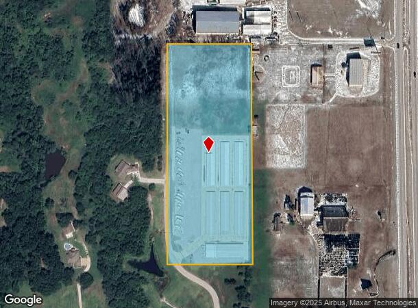
2155 W 181St St S
Tulsa, OK
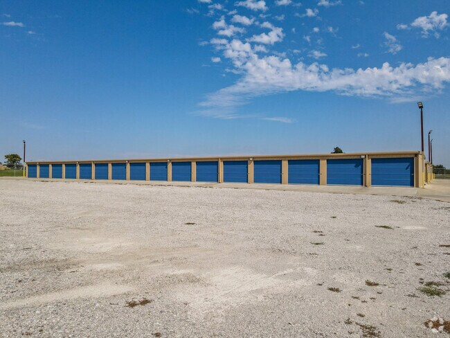
Cotton Creek Mini-Storage
84986-72-34-73330
LOT 4 BLOCK 1
Publicstorage
Tulsa
A
Oklahoma
40143C0420K
4
2025
9.26 AC
2025
South
007703
Tulsa
58,200 SF
DEMOGRAPHICS near 2155 W 181St St S
1 Mile
3 Mile
5 Mile
2024 Total Population
454
3,043
19,317
2029 Population
463
3,114
19,776
Pop Growth 2024-2029
+ 1.98%
+ 2.33%
+ 2.38%
Average Age
38
38
37
2024 Total Households
155
1,050
6,804
HH Growth 2024-2029
+ 1.94%
+ 2.38%
+ 2.40%
Median Household Inc
$107,500
$103,992
$73,217
Avg Household Size
2.90
2.90
2.80
2024 Avg HH Vehicles
3.00
3.00
2.00
Median Home Value
$291,999
$240,934
$190,762
Median Year Built
1995
2001
1992
Nearby Places
Map Layers
Map Styles
 Street
 Aerial
- Restaurants
- Banks
- Shops
- Fitness
- Groceries
PUBLIC TRANSPORTATION
AIRPORT
Tulsa International
DRIVE
WALK
Distance
Tulsa International
36 min
27.0 mi
Freight Ports
Tulsa Port Of Catoosa
DRIVE
WALK
Distance
Tulsa Port Of Catoosa
45 min
35.7 mi
Nearby Properties
Address
Land Use
TOTAL SIZE
Lot Size
Zoning
Address
Land Use
TOTAL SIZE
Lot Size
Zoning
49,735 SF
14.35 AC
CG
Address
Land Use
TOTAL SIZE
Lot Size
Zoning
116,016 SF
54.80 AC
CG
Address
Land Use
TOTAL SIZE
Lot Size
Zoning
6,702 SF
3.63 AC
AG
Address
Land Use
TOTAL SIZE
Lot Size
Zoning
38,476 SF
18.68 AC
CG
Address
Land Use
TOTAL SIZE
Lot Size
Zoning
68,298 SF
28.61 AC
CG
Address
Land Use
TOTAL SIZE
Lot Size
Zoning
18,078 SF
14.73 AC
IL
Address
Land Use
TOTAL SIZE
Lot Size
Zoning
22.20 AC
AG
Address
Land Use
TOTAL SIZE
Lot Size
Zoning
197,644 SF
32.39 AC
IL
Address
Land Use
TOTAL SIZE
Lot Size
Zoning
6.76 AC
AG
Address
Land Use
TOTAL SIZE
Lot Size
Zoning
840 SF
10.43 AC
AG
Address
Land Use
TOTAL SIZE
Lot Size
Zoning
5,800 SF
1.86 AC
CS
Address
Land Use
TOTAL SIZE
Lot Size
Zoning
108,000 SF
8.81 AC
AG
Address
Land Use
TOTAL SIZE
Lot Size
Zoning
72,456 SF
3.77 AC
RM2
Address
Land Use
TOTAL SIZE
Lot Size
Zoning
83,598 SF
19.93 AC
IL
Address
Land Use
TOTAL SIZE
Lot Size
Zoning
2,234 SF
0.91 AC
CG
Address
Land Use
TOTAL SIZE
Lot Size
Zoning
5,944 SF
1.32 AC
CG
Address
Land Use
TOTAL SIZE
Lot Size
Zoning
4,748 SF
1.26 AC
CG
Address
Land Use
TOTAL SIZE
Lot Size
Zoning
18,920 SF
3 AC
CS
Address
Land Use
TOTAL SIZE
Lot Size
Zoning
5,704 SF
66.47 AC
AG
Address
Land Use
TOTAL SIZE
Lot Size
Zoning
4,319 SF
1.13 AC
CS
Address
Land Use
TOTAL SIZE
Lot Size
Zoning
36,100 SF
5.37 AC
RS3
Address
Land Use
TOTAL SIZE
Lot Size
Zoning
1,500 SF
14.67 AC
CG
Address
Land Use
TOTAL SIZE
Lot Size
Zoning
10,146 SF
3.69 AC
IL
Address
Land Use
TOTAL SIZE
Lot Size
Zoning
51,020 SF
9.16 AC
CG
Address
Land Use
TOTAL SIZE
Lot Size
Zoning
2,176 SF
0.41 AC
Address
Land Use
TOTAL SIZE
Lot Size
Zoning
9,800 SF
5.82 AC
IL
Address
Land Use
TOTAL SIZE
Lot Size
Zoning
600 SF
19.60 AC
AG
Address
Land Use
TOTAL SIZE
Lot Size
Zoning
4,067 SF
3.04 AC
CG
The World's #1 Commercial Real Estate Marketplace
Connect with us
© 2026 CoStar Group
The information above has been obtained from sources believed reliable. While we do not doubt its accuracy we have not verified it and make no guarantee, warranty or representation about it. It is your responsibility to independently confirm its accuracy and completeness. Any projections, opinions, assumptions, or estimates used are for example only and do not represent the current or future performance of the property. The value of this transaction to you depends on tax and other factors which should be evaluated by your tax, financial, and legal advisors. You and your advisors should conduct a careful, independent investigation of the property to determine to your satisfaction the suitability of the property for your needs.