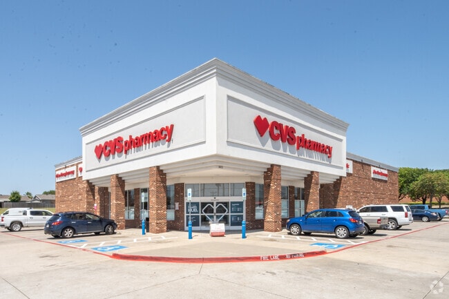
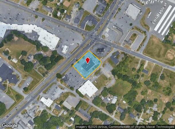
Property Record
21550 Timberlake Rd, Lynchburg, VA 24502
NEARBY LISTINGS FOR SALE OR LEASE
Property Detail
21550 Timberlake Rd
021A-01000-005-0
TIMBERLAKE RD
Commercialnec
Campbell
X
Virginia
51019C0400D
1.13 AC
2025
Lynchburg
2025
Other Market Areas
020401
Lynchburg, VA
10,848 SF
DEMOGRAPHICS near 21550 Timberlake Rd
1 Mile
3 Mile
5 Mile
2024 Total Population
5,650
35,063
63,801
2029 Population
5,578
35,036
64,369
Pop Growth 2024-2029
(1.27%)
(0.08%)
+ 0.89%
Average Age
40
39
39
2024 Total Households
2,476
14,889
26,041
HH Growth 2024-2029
(1.21%)
(0.10%)
+ 0.85%
Median Household Inc
$57,354
$62,822
$63,945
Avg Household Size
2.30
2.30
2.30
2024 Avg HH Vehicles
2.00
2.00
2.00
Median Home Value
$174,051
$212,690
$220,797
Median Year Built
1979
1987
1988
Nearby Places
- Restaurants
- Banks
- Shops
- Fitness
- Groceries
PUBLIC TRANSPORTATION
COMMUTER RAIL
DRIVE
WALK
Distance
15 min
8.7 mi
AIRPORT
Lynchburg Regional/Preston Glenn Field
DRIVE
WALK
Distance
Lynchburg Regional/Preston Glenn Field
10 min
3.8 mi
SALE & LEASE HISTORY
LISTING DATE
SALE/LEASE

Aug 13, 2020
For Sale
Nearby Properties
Address
Land Use
TOTAL SIZE
Lot Size
Zoning
Address
Land Use
TOTAL SIZE
Lot Size
Zoning
22.70 AC
Address
Land Use
TOTAL SIZE
Lot Size
Zoning
912 SF
52.88 AC
BGC
Address
Land Use
TOTAL SIZE
Lot Size
Zoning
207,379 SF
10.24 AC
250905
Address
Land Use
TOTAL SIZE
Lot Size
Zoning
4,672 SF
905.07 AC
BHC
Address
Land Use
TOTAL SIZE
Lot Size
Zoning
199,056 SF
16.21 AC
R1
Address
Land Use
TOTAL SIZE
Lot Size
Zoning
36,168 SF
7.96 AC
BGC
Address
Land Use
TOTAL SIZE
Lot Size
Zoning
155,125 SF
38.67 AC
250129
Address
Land Use
TOTAL SIZE
Lot Size
Zoning
9,508 SF
8.54 AC
RMF
Address
Land Use
TOTAL SIZE
Lot Size
Zoning
1,120 SF
16.81 AC
RMF
Address
Land Use
TOTAL SIZE
Lot Size
Zoning
3,478 SF
13.10 AC
RMFC
Address
Land Use
TOTAL SIZE
Lot Size
Zoning
537,608 SF
47.65 AC
152919
Address
Land Use
TOTAL SIZE
Lot Size
Zoning
88,286 SF
11.85 AC
Address
Land Use
TOTAL SIZE
Lot Size
Zoning
161,333 SF
10.60 AC
2119
Address
Land Use
TOTAL SIZE
Lot Size
Zoning
192,704 SF
8.35 AC
252905
Address
Land Use
TOTAL SIZE
Lot Size
Zoning
76,421 SF
25.07 AC
R2RC
Address
Land Use
TOTAL SIZE
Lot Size
Zoning
172,074 SF
9.93 AC
Address
Land Use
TOTAL SIZE
Lot Size
Zoning
95,792 SF
3.28 AC
Address
Land Use
TOTAL SIZE
Lot Size
Zoning
96,428 SF
4.38 AC
Address
Land Use
TOTAL SIZE
Lot Size
Zoning
124,709 SF
6.14 AC
092305
Address
Land Use
TOTAL SIZE
Lot Size
Zoning
235,213 SF
24.61 AC
I2
Address
Land Use
TOTAL SIZE
Lot Size
Zoning
91,588 SF
10.96 AC
B3R4
Address
Land Use
TOTAL SIZE
Lot Size
Zoning
22,170 SF
18.84 AC
BGC
Address
Land Use
TOTAL SIZE
Lot Size
Zoning
101,183 SF
3.94 AC
R4
Address
Land Use
TOTAL SIZE
Lot Size
Zoning
58,352 SF
1.91 AC
Address
Land Use
TOTAL SIZE
Lot Size
Zoning
214,400 SF
98.14 AC
Address
Land Use
TOTAL SIZE
Lot Size
Zoning
23,633 SF
6.36 AC
RSF
Address
Land Use
TOTAL SIZE
Lot Size
Zoning
3,199 SF
1.36 AC
R1
Address
Land Use
TOTAL SIZE
Lot Size
Zoning
19,200 SF
17.13 AC
IG
Address
Land Use
TOTAL SIZE
Lot Size
Zoning
41,808 SF
12.16 AC
RSF
Address
Land Use
TOTAL SIZE
Lot Size
Zoning
95,130 SF
17.79 AC
090501
The World's #1 Commercial Real Estate Marketplace
Connect with us
© 2025 CoStar Group
The information above has been obtained from sources believed reliable. While we do not doubt its accuracy we have not verified it and make no guarantee, warranty or representation about it. It is your responsibility to independently confirm its accuracy and completeness. Any projections, opinions, assumptions, or estimates used are for example only and do not represent the current or future performance of the property. The value of this transaction to you depends on tax and other factors which should be evaluated by your tax, financial, and legal advisors. You and your advisors should conduct a careful, independent investigation of the property to determine to your satisfaction the suitability of the property for your needs.