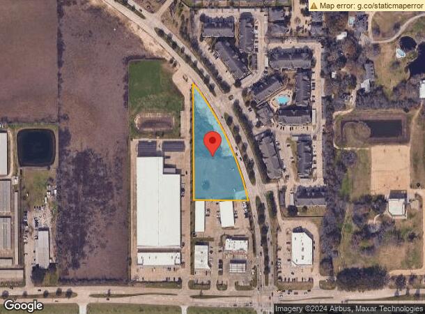
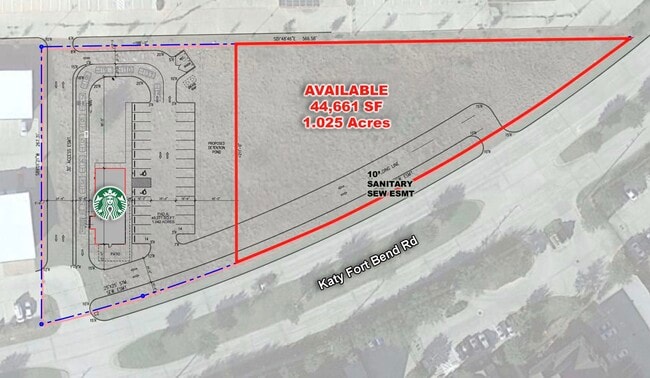
Property Record
2155 Katy Fort Bend Rd, Katy, TX 77493
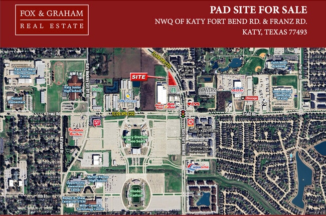
NEARBY LISTINGS FOR SALE OR LEASE
Property Detail
2155 Katy Fort Bend Rd
1316680010005
Kfb Franz Sec 2
Restaurantdrivein
RES A3 BLK 1 KFB FRANZ SEC 2
X
Harris
48201C0595M
Texas
2024
2.07 AC
2025
Katy/Grand Parkway West
542800
Houston
2,268 SF
Houston-The Woodlands-Sugar Land, TX
DEMOGRAPHICS near 2155 Katy Fort Bend Rd
1 Mile
3 Mile
5 Mile
2024 Total Population
14,434
87,956
224,553
2029 Population
14,975
94,993
244,710
Pop Growth 2024-2029
+ 3.75%
+ 8.00%
+ 8.98%
Average Age
36
36
35
2024 Total Households
4,719
29,792
72,979
HH Growth 2024-2029
+ 3.79%
+ 7.74%
+ 8.74%
Median Household Inc
$92,750
$94,069
$96,843
Avg Household Size
3.00
2.90
3.00
2024 Avg HH Vehicles
2.00
2.00
2.00
Median Home Value
$243,148
$267,839
$274,409
Median Year Built
2005
2010
2008
Nearby Places
- Restaurants
- Banks
- Shops
- Fitness
- Groceries
SALE & LEASE HISTORY
LISTING DATE
SALE/LEASE

Apr 22, 2024
For Sale
Apr 21, 2023
For Sale
Nearby Properties
Address
Land Use
TOTAL SIZE
Lot Size
Zoning
Address
Land Use
TOTAL SIZE
Lot Size
Zoning
1,655,920 SF
121.35 AC
Address
Land Use
TOTAL SIZE
Lot Size
Zoning
720,217 SF
65.17 AC
Address
Land Use
TOTAL SIZE
Lot Size
Zoning
807,360 SF
54.15 AC
Address
Land Use
TOTAL SIZE
Lot Size
Zoning
350,883 SF
29.41 AC
Address
Land Use
TOTAL SIZE
Lot Size
Zoning
765,465 SF
63.65 AC
Address
Land Use
TOTAL SIZE
Lot Size
Zoning
614,847 SF
42 AC
Address
Land Use
TOTAL SIZE
Lot Size
Zoning
329,918 SF
19.18 AC
Address
Land Use
TOTAL SIZE
Lot Size
Zoning
380,278 SF
12.61 AC
Address
Land Use
TOTAL SIZE
Lot Size
Zoning
1,051,080 SF
54.27 AC
Address
Land Use
TOTAL SIZE
Lot Size
Zoning
346,736 SF
14.28 AC
Address
Land Use
TOTAL SIZE
Lot Size
Zoning
352,733 SF
13.66 AC
Address
Land Use
TOTAL SIZE
Lot Size
Zoning
455,592 SF
27.53 AC
Address
Land Use
TOTAL SIZE
Lot Size
Zoning
455,592 SF
20.95 AC
Address
Land Use
TOTAL SIZE
Lot Size
Zoning
41,083 SF
23.66 AC
Address
Land Use
TOTAL SIZE
Lot Size
Zoning
339,835 SF
12.09 AC
Address
Land Use
TOTAL SIZE
Lot Size
Zoning
278,212 SF
8.15 AC
Address
Land Use
TOTAL SIZE
Lot Size
Zoning
351,758 SF
18.23 AC
Address
Land Use
TOTAL SIZE
Lot Size
Zoning
361,382 SF
14.60 AC
Address
Land Use
TOTAL SIZE
Lot Size
Zoning
375,757 SF
18.37 AC
Address
Land Use
TOTAL SIZE
Lot Size
Zoning
297,040 SF
11.64 AC
Address
Land Use
TOTAL SIZE
Lot Size
Zoning
363,173 SF
13.57 AC
Address
Land Use
TOTAL SIZE
Lot Size
Zoning
327,699 SF
11.64 AC
Address
Land Use
TOTAL SIZE
Lot Size
Zoning
6.13 AC
Address
Land Use
TOTAL SIZE
Lot Size
Zoning
12.50 AC
Address
Land Use
TOTAL SIZE
Lot Size
Zoning
348,199 SF
16.69 AC
Address
Land Use
TOTAL SIZE
Lot Size
Zoning
440,214 SF
23.66 AC
Address
Land Use
TOTAL SIZE
Lot Size
Zoning
261,803 SF
12.51 AC
Address
Land Use
TOTAL SIZE
Lot Size
Zoning
319,341 SF
14.88 AC
Address
Land Use
TOTAL SIZE
Lot Size
Zoning
324,201 SF
12.39 AC
Address
Land Use
TOTAL SIZE
Lot Size
Zoning
290,973 SF
15 AC
The World's #1 Commercial Real Estate Marketplace
Connect with us
© 2025 CoStar Group
The information above has been obtained from sources believed reliable. While we do not doubt its accuracy we have not verified it and make no guarantee, warranty or representation about it. It is your responsibility to independently confirm its accuracy and completeness. Any projections, opinions, assumptions, or estimates used are for example only and do not represent the current or future performance of the property. The value of this transaction to you depends on tax and other factors which should be evaluated by your tax, financial, and legal advisors. You and your advisors should conduct a careful, independent investigation of the property to determine to your satisfaction the suitability of the property for your needs.