Property Record
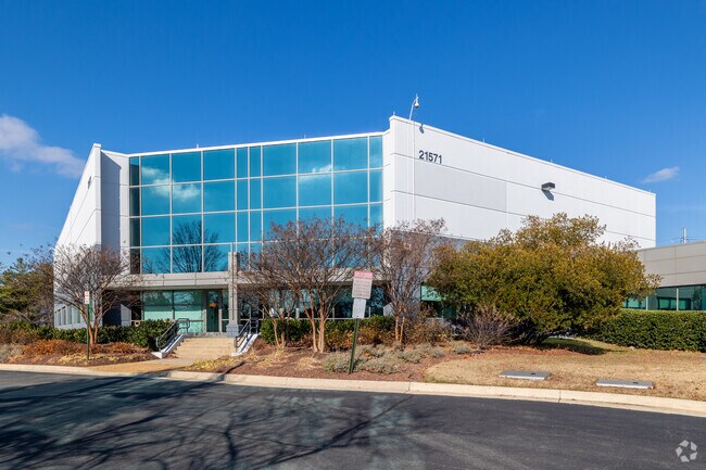
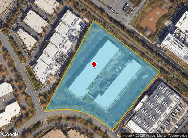
21571 Beaumeade Cir, Ashburn, VA 20147
NEARBY LISTINGS FOR SALE OR LEASE
Property Detail
21571 Beaumeade Cir
Washington-Arlington-Alexandria, DC-VA-MD-WV
Beaumeade Ph.1
060-20-2337
BEAUMEADE PH.1 S.1 L.29 200912210084444 PC E-659-5, 994--1477
Warehouse
Loudoun
X
Virginia
51107C0265E
29
2025
14.15 AC
2025
Rt 28/Dulles North
611006
Washington, DC
164,455 SF
DEMOGRAPHICS near 21571 Beaumeade Cir
1 Mile
3 Mile
5 Mile
2024 Total Population
4,190
84,705
232,477
2029 Population
4,559
91,823
248,136
Pop Growth 2024-2029
+ 8.81%
+ 8.40%
+ 6.74%
Average Age
59
39
38
2024 Total Households
2,125
31,089
79,246
HH Growth 2024-2029
+ 9.79%
+ 8.70%
+ 7.06%
Median Household Inc
$103,836
$126,894
$142,794
Avg Household Size
1.90
2.70
2.90
2024 Avg HH Vehicles
1.00
2.00
2.00
Median Home Value
$649,211
$616,019
$633,822
Median Year Built
2010
1998
1998
Nearby Places
Map Layers
Map Styles
 Street
 Aerial
- Restaurants
- Banks
- Shops
- Fitness
- Groceries
PUBLIC TRANSPORTATION
AIRPORT
Washington Dulles International
DRIVE
WALK
Distance
Washington Dulles International
18 min
7.4 mi
Ronald Reagan Washington Ntl
DRIVE
WALK
Distance
Ronald Reagan Washington Ntl
51 min
32.6 mi
Freight Ports
Port of Baltimore
DRIVE
WALK
Distance
Port of Baltimore
90 min
64.5 mi
Nearby Properties
Address
Land Use
TOTAL SIZE
Lot Size
Zoning
Address
Land Use
TOTAL SIZE
Lot Size
Zoning
2,735,138 SF
123.03 AC
PDAAAR
Address
Land Use
TOTAL SIZE
Lot Size
Zoning
431.05 AC
LB:PRC
Address
Land Use
TOTAL SIZE
Lot Size
Zoning
125.80 AC
TRC
Address
Land Use
TOTAL SIZE
Lot Size
Zoning
414,268 SF
43.68 AC
R16
Address
Land Use
TOTAL SIZE
Lot Size
Zoning
341,831 SF
31.21 AC
PDH6
Address
Land Use
TOTAL SIZE
Lot Size
Zoning
624,852 SF
22.54 AC
R24
Address
Land Use
TOTAL SIZE
Lot Size
Zoning
549,027 SF
21.01 AC
R16
Address
Land Use
TOTAL SIZE
Lot Size
Zoning
119,087 SF
339.95 AC
PDIP
Address
Land Use
TOTAL SIZE
Lot Size
Zoning
430,507 SF
25.60 AC
R16
Address
Land Use
TOTAL SIZE
Lot Size
Zoning
100,121 SF
2.20 AC
PDIP
Address
Land Use
TOTAL SIZE
Lot Size
Zoning
396,198 SF
5.84 AC
PDMUB
Address
Land Use
TOTAL SIZE
Lot Size
Zoning
364,146 SF
38.05 AC
CCSC
Address
Land Use
TOTAL SIZE
Lot Size
Zoning
498,598 SF
21.89 AC
R16
Address
Land Use
TOTAL SIZE
Lot Size
Zoning
316,325 SF
18.08 AC
R16
Address
Land Use
TOTAL SIZE
Lot Size
Zoning
404,709 SF
18.57 AC
R24
Address
Land Use
TOTAL SIZE
Lot Size
Zoning
29,800 SF
43.29 AC
IP
Address
Land Use
TOTAL SIZE
Lot Size
Zoning
680,252 SF
19.23 AC
R16
Address
Land Use
TOTAL SIZE
Lot Size
Zoning
454,700 SF
54.92 AC
PDGI
Address
Land Use
TOTAL SIZE
Lot Size
Zoning
320,609 SF
2.02 AC
PDTRC
Address
Land Use
TOTAL SIZE
Lot Size
Zoning
198,672 SF
21.41 AC
R16
Address
Land Use
TOTAL SIZE
Lot Size
Zoning
287,479 SF
14.90 AC
PDAAAR
Address
Land Use
TOTAL SIZE
Lot Size
Zoning
152,394 SF
10.73 AC
PDIP
Address
Land Use
TOTAL SIZE
Lot Size
Zoning
308,805 SF
34.45 AC
PDCCRC
Address
Land Use
TOTAL SIZE
Lot Size
Zoning
218,277 SF
14.54 AC
PDH3
Address
Land Use
TOTAL SIZE
Lot Size
Zoning
177,571 SF
16.23 AC
R16
Address
Land Use
TOTAL SIZE
Lot Size
Zoning
135,513 SF
8.49 AC
PDIP
Address
Land Use
TOTAL SIZE
Lot Size
Zoning
287,050 SF
11.05 AC
R24
Address
Land Use
TOTAL SIZE
Lot Size
Zoning
1,026,767 SF
71 AC
PDSC
The World's #1 Commercial Real Estate Marketplace
Connect with us
© 2026 CoStar Group
The information above has been obtained from sources believed reliable. While we do not doubt its accuracy we have not verified it and make no guarantee, warranty or representation about it. It is your responsibility to independently confirm its accuracy and completeness. Any projections, opinions, assumptions, or estimates used are for example only and do not represent the current or future performance of the property. The value of this transaction to you depends on tax and other factors which should be evaluated by your tax, financial, and legal advisors. You and your advisors should conduct a careful, independent investigation of the property to determine to your satisfaction the suitability of the property for your needs.