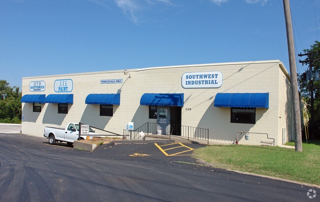
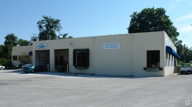
Property Record
2159 E Chestnut Expy, Springfield, MO 65802

Property Detail
2159 E Chestnut Expy
12-17-301-003
6.63A M/L E 300 FT S3/4 S1/2 SW1/4 17/29/21 (EX ST)
Warehouse
GREENE
INC
Missouri
AE The base floodplain where base flood elevations are provided. AE Zones are now used on new format FIRMs instead of A1-A30 Zones.
6.63 AC
2025
Northeast
2025
Springfield
002200
Springfield, MO
10,580 SF
NEARBY LISTINGS FOR SALE OR LEASE
DEMOGRAPHICS near 2159 E Chestnut Expy
1 mile
3 mile
5 mile
2025 Total Population
7,244
75,445
157,075
2030 Population
7,394
77,588
161,450
Pop Growth 2025-2030
+ 2.07%
+ 2.84%
+ 2.79%
Average Age
37
36
38
2025 Total Households
3,245
33,205
69,787
HH Growth 2025-2030
+ 2.16%
+ 3.07%
+ 2.99%
Median Household Inc
$42,392
$47,277
$49,072
Avg Household Size
2.00
2.00
2.10
2025 Avg HH Vehicles
2.00
2.00
2.00
Median Home Value
$161,814
$193,737
$194,533
Median Year Built
1971
1969
1975
Nearby Places
Map Layers
Map Styles
 Street
 Aerial
Transit
 Traffic
 Biking
Places
Listings with unknown addresses are not visible on the map
- Restaurants
- Banks
- Shops
- Fitness
- Groceries
PUBLIC TRANSPORTATION
AIRPORT
Springfield-Branson Ntl
Drive
Walk
Distance
Springfield-Branson Ntl
25 min
14.2 mi
Freight Ports
Tulsa Port of Inola
Drive
Walk
Distance
Tulsa Port of Inola
198 min
173.5 mi
Nearby Properties
Address
Land Use
TOTAL SIZE
Lot Size
Zoning
Address
Land Use
TOTAL SIZE
Lot Size
Zoning
11.54 AC
Address
Land Use
TOTAL SIZE
Lot Size
Zoning
2,981,315 SF
76.43 AC
INC
Address
Land Use
TOTAL SIZE
Lot Size
Zoning
35.56 AC
INC
Address
Land Use
TOTAL SIZE
Lot Size
Zoning
343,758 SF
29.81 AC
INC
Address
Land Use
TOTAL SIZE
Lot Size
Zoning
297,760 SF
4.22 AC
INC
Address
Land Use
TOTAL SIZE
Lot Size
Zoning
233,445 SF
8.17 AC
INC
Address
Land Use
TOTAL SIZE
Lot Size
Zoning
1,728,457 SF
123.60 AC
INC
Address
Land Use
TOTAL SIZE
Lot Size
Zoning
779,221 SF
45.03 AC
INC
Address
Land Use
TOTAL SIZE
Lot Size
Zoning
340,000 SF
37.93 AC
INC
Address
Land Use
TOTAL SIZE
Lot Size
Zoning
359,020 SF
14 AC
INC
Address
Land Use
TOTAL SIZE
Lot Size
Zoning
18.35 AC
Address
Land Use
TOTAL SIZE
Lot Size
Zoning
224,730 SF
19.99 AC
INC
Address
Land Use
TOTAL SIZE
Lot Size
Zoning
355,759 SF
2.23 AC
INC
Address
Land Use
TOTAL SIZE
Lot Size
Zoning
5.84 AC
INC
Address
Land Use
TOTAL SIZE
Lot Size
Zoning
10.29 AC
INC.
Address
Land Use
TOTAL SIZE
Lot Size
Zoning
805,370 SF
54.30 AC
INC
Address
Land Use
TOTAL SIZE
Lot Size
Zoning
24.54 AC
INC.
Address
Land Use
TOTAL SIZE
Lot Size
Zoning
13.88 AC
INC
Address
Land Use
TOTAL SIZE
Lot Size
Zoning
1,825 SF
4.31 AC
INC
Address
Land Use
TOTAL SIZE
Lot Size
Zoning
25.51 AC
INC
Address
Land Use
TOTAL SIZE
Lot Size
Zoning
4.63 AC
O-2
Address
Land Use
TOTAL SIZE
Lot Size
Zoning
5.47 AC
INC
Address
Land Use
TOTAL SIZE
Lot Size
Zoning
143,774 SF
5.85 AC
INC
Address
Land Use
TOTAL SIZE
Lot Size
Zoning
1.99 AC
INC
Address
Land Use
TOTAL SIZE
Lot Size
Zoning
108,153 SF
7.37 AC
INC.
Address
Land Use
TOTAL SIZE
Lot Size
Zoning
290,844 SF
20.78 AC
INC
Address
Land Use
TOTAL SIZE
Lot Size
Zoning
127,740 SF
27.70 AC
INC
Address
Land Use
TOTAL SIZE
Lot Size
Zoning
324,341 SF
43 AC
INC
Address
Land Use
TOTAL SIZE
Lot Size
Zoning
92,702 SF
42.54 AC
INC
Address
Land Use
TOTAL SIZE
Lot Size
Zoning
20.11 AC
INC
The World's #1 Commercial Real Estate Marketplace
Connect with us
© 2026 CoStar Group
The information above has been obtained from sources believed reliable. While we do not doubt its accuracy we have not verified it and make no guarantee, warranty or representation about it. It is your responsibility to independently confirm its accuracy and completeness. Any projections, opinions, assumptions, or estimates used are for example only and do not represent the current or future performance of the property. The value of this transaction to you depends on tax and other factors which should be evaluated by your tax, financial, and legal advisors. You and your advisors should conduct a careful, independent investigation of the property to determine to your satisfaction the suitability of the property for your needs.