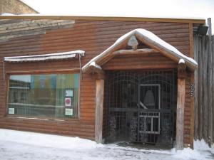
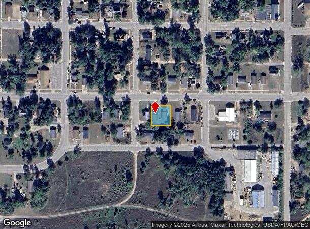
Property Record
216 2Nd St Ne, Cass Lake, MN 56633
NEARBY LISTINGS FOR SALE OR LEASE
-
-
View all Cass Lake listings for sale on LoopNet.com
Property Detail
216 2Nd St Ne
Other Market Areas
Original Plat Of Cass Lake
Brainerd, MN
LOTS 7 THRU 10, BLK 10
85-341-1040
Cass
Governmentalpublicusegeneral
Minnesota
2025
7-10
2024
0.02 AC
940002
DEMOGRAPHICS near 216 2Nd St Ne
1 Mile
3 Mile
5 Mile
2024 Total Population
746
1,727
3,180
2029 Population
775
1,787
3,361
Pop Growth 2024-2029
+ 3.89%
+ 3.47%
+ 5.69%
Average Age
35
35
37
2024 Total Households
249
556
1,067
HH Growth 2024-2029
+ 3.61%
+ 3.24%
+ 5.81%
Median Household Inc
$54,324
$54,657
$56,690
Avg Household Size
2.80
2.90
2.80
2024 Avg HH Vehicles
2.00
2.00
2.00
Median Home Value
$89,725
$102,976
$172,282
Median Year Built
1972
1978
1984
Nearby Places
Map Layers
Map Styles
 Street
 Aerial
- Restaurants
- Banks
- Shops
- Fitness
- Groceries
PUBLIC TRANSPORTATION
AIRPORT
Bemidji Regional
DRIVE
WALK
Distance
Bemidji Regional
24 min
20.7 mi
Freight Ports
Port Milwaukee
DRIVE
WALK
Distance
Port Milwaukee
603 min
531.7 mi
Nearby Properties
Address
Land Use
TOTAL SIZE
Lot Size
Zoning
Address
Land Use
TOTAL SIZE
Lot Size
Zoning
7.35 AC
Address
Land Use
TOTAL SIZE
Lot Size
Zoning
163.52 AC
Address
Land Use
TOTAL SIZE
Lot Size
Zoning
Address
Land Use
TOTAL SIZE
Lot Size
Zoning
39.35 AC
Address
Land Use
TOTAL SIZE
Lot Size
Zoning
0.32 AC
Address
Land Use
TOTAL SIZE
Lot Size
Zoning
6.35 AC
Address
Land Use
TOTAL SIZE
Lot Size
Zoning
0.27 AC
Address
Land Use
TOTAL SIZE
Lot Size
Zoning
1,400 SF
56.22 AC
Address
Land Use
TOTAL SIZE
Lot Size
Zoning
13.26 AC
Address
Land Use
TOTAL SIZE
Lot Size
Zoning
Address
Land Use
TOTAL SIZE
Lot Size
Zoning
15.78 AC
Address
Land Use
TOTAL SIZE
Lot Size
Zoning
377.64 AC
Address
Land Use
TOTAL SIZE
Lot Size
Zoning
Address
Land Use
TOTAL SIZE
Lot Size
Zoning
46.09 AC
Address
Land Use
TOTAL SIZE
Lot Size
Zoning
6,600 SF
7.66 AC
Address
Land Use
TOTAL SIZE
Lot Size
Zoning
1,120 SF
19 AC
Address
Land Use
TOTAL SIZE
Lot Size
Zoning
Address
Land Use
TOTAL SIZE
Lot Size
Zoning
11.09 AC
Address
Land Use
TOTAL SIZE
Lot Size
Zoning
468.14 AC
Address
Land Use
TOTAL SIZE
Lot Size
Zoning
79.63 AC
Address
Land Use
TOTAL SIZE
Lot Size
Zoning
13.30 AC
Address
Land Use
TOTAL SIZE
Lot Size
Zoning
0.09 AC
Address
Land Use
TOTAL SIZE
Lot Size
Zoning
10.06 AC
Address
Land Use
TOTAL SIZE
Lot Size
Zoning
10.05 AC
Address
Land Use
TOTAL SIZE
Lot Size
Zoning
Address
Land Use
TOTAL SIZE
Lot Size
Zoning
10.38 AC
Address
Land Use
TOTAL SIZE
Lot Size
Zoning
35,780 SF
0.27 AC
Address
Land Use
TOTAL SIZE
Lot Size
Zoning
864 SF
10.97 AC
Address
Land Use
TOTAL SIZE
Lot Size
Zoning
The World's #1 Commercial Real Estate Marketplace
Connect with us
© 2025 CoStar Group
The information above has been obtained from sources believed reliable. While we do not doubt its accuracy we have not verified it and make no guarantee, warranty or representation about it. It is your responsibility to independently confirm its accuracy and completeness. Any projections, opinions, assumptions, or estimates used are for example only and do not represent the current or future performance of the property. The value of this transaction to you depends on tax and other factors which should be evaluated by your tax, financial, and legal advisors. You and your advisors should conduct a careful, independent investigation of the property to determine to your satisfaction the suitability of the property for your needs.