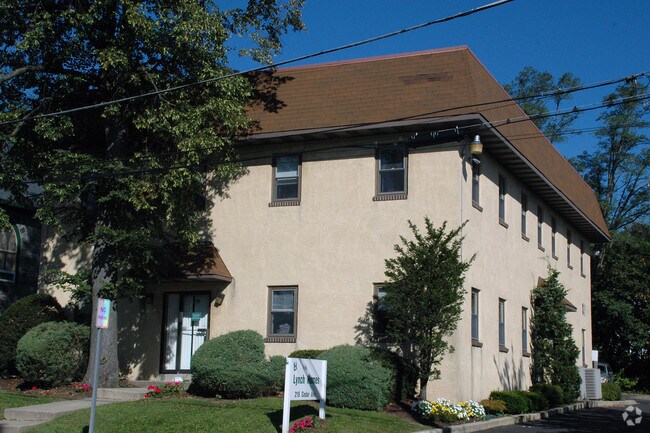
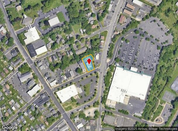
Property Record
216 Cedar Ave, Willow Grove, PA 19090

NEARBY LISTINGS FOR SALE OR LEASE
Property Detail
216 Cedar Ave
Philadelphia-Camden-Wilmington, PA-NJ-DE-MD
Dominica Larosa
59-00-02629-003
L 87-85 INC PT 84
Miscellaneous
Montgomery
X
Pennsylvania
42091C0313G
87
2024
0.31 AC
2025
Horsham/Willow Grove
200307
Philadelphia
4,800 SF
DEMOGRAPHICS near 216 Cedar Ave
1 Mile
3 Mile
5 Mile
2024 Total Population
15,737
89,553
232,923
2029 Population
16,034
91,024
235,706
Pop Growth 2024-2029
+ 1.89%
+ 1.64%
+ 1.19%
Average Age
41
41
43
2024 Total Households
6,183
34,637
89,836
HH Growth 2024-2029
+ 2.02%
+ 1.73%
+ 1.26%
Median Household Inc
$93,308
$100,219
$100,511
Avg Household Size
2.50
2.50
2.50
2024 Avg HH Vehicles
2.00
2.00
2.00
Median Home Value
$284,720
$336,179
$362,292
Median Year Built
1958
1960
1963
Nearby Places
- Restaurants
- Banks
- Shops
- Fitness
- Groceries
PUBLIC TRANSPORTATION
COMMUTER RAIL
Willow Grove (R2 - Southeastern Pennsylvania Transportation Authority Regional Rail (SEPTA Regional Rail))
DRIVE
WALK
Distance
Willow Grove (R2 - Southeastern Pennsylvania Transportation Authority Regional Rail (SEPTA Regional Rail))
1 min
6 min
0.3 mi
Crestmont (R2 - Southeastern Pennsylvania Transportation Authority Regional Rail (SEPTA Regional Rail))
DRIVE
WALK
Distance
Crestmont (R2 - Southeastern Pennsylvania Transportation Authority Regional Rail (SEPTA Regional Rail))
4 min
1.4 mi
AIRPORT
Trenton Mercer
DRIVE
WALK
Distance
Trenton Mercer
39 min
26.9 mi
Philadelphia International
DRIVE
WALK
Distance
Philadelphia International
50 min
28.0 mi
Freight Ports
Port of Philadelphia
DRIVE
WALK
Distance
Port of Philadelphia
27 min
13.8 mi
SALE & LEASE HISTORY
LISTING DATE
SALE/LEASE

Sep 10, 2024
For Sale
Nearby Properties
Address
Land Use
TOTAL SIZE
Lot Size
Zoning
Address
Land Use
TOTAL SIZE
Lot Size
Zoning
1,556,628 SF
7.70 AC
AO
Address
Land Use
TOTAL SIZE
Lot Size
Zoning
794,476 SF
30.14 AC
PB
Address
Land Use
TOTAL SIZE
Lot Size
Zoning
487,936 SF
58.50 AC
T
Address
Land Use
TOTAL SIZE
Lot Size
Zoning
335,203 SF
31.20 AC
C1
Address
Land Use
TOTAL SIZE
Lot Size
Zoning
377,044 SF
58.73 AC
INST
Address
Land Use
TOTAL SIZE
Lot Size
Zoning
752,716 SF
0.29 AC
OC
Address
Land Use
TOTAL SIZE
Lot Size
Zoning
571,213 SF
67.31 AC
M
Address
Land Use
TOTAL SIZE
Lot Size
Zoning
498,072 SF
5.39 AC
TC1
Address
Land Use
TOTAL SIZE
Lot Size
Zoning
316,163 SF
45.32 AC
T
Address
Land Use
TOTAL SIZE
Lot Size
Zoning
557,091 SF
21.87 AC
AO
Address
Land Use
TOTAL SIZE
Lot Size
Zoning
272,344 SF
9.76 AC
I2
Address
Land Use
TOTAL SIZE
Lot Size
Zoning
343,852 SF
8.42 AC
I
Address
Land Use
TOTAL SIZE
Lot Size
Zoning
435,888 SF
16.35 AC
MD
Address
Land Use
TOTAL SIZE
Lot Size
Zoning
251,655 SF
48.95 AC
SC
Address
Land Use
TOTAL SIZE
Lot Size
Zoning
242,560 SF
1.40 AC
OC
Address
Land Use
TOTAL SIZE
Lot Size
Zoning
167,743 SF
20.70 AC
T
Address
Land Use
TOTAL SIZE
Lot Size
Zoning
259,505 SF
42.19 AC
V
Address
Land Use
TOTAL SIZE
Lot Size
Zoning
130,115 SF
10.45 AC
PB
Address
Land Use
TOTAL SIZE
Lot Size
Zoning
139,087 SF
2.76 AC
V
Address
Land Use
TOTAL SIZE
Lot Size
Zoning
251,935 SF
13.03 AC
TC1
Address
Land Use
TOTAL SIZE
Lot Size
Zoning
257,010 SF
34.12 AC
INST
Address
Land Use
TOTAL SIZE
Lot Size
Zoning
84,400 SF
4.70 AC
I
Address
Land Use
TOTAL SIZE
Lot Size
Zoning
193,334 SF
32.50 AC
NR
Address
Land Use
TOTAL SIZE
Lot Size
Zoning
236,808 SF
17.66 AC
PB
Address
Land Use
TOTAL SIZE
Lot Size
Zoning
388,525 SF
25.28 AC
OC
Address
Land Use
TOTAL SIZE
Lot Size
Zoning
309,264 SF
9.93 AC
I
Address
Land Use
TOTAL SIZE
Lot Size
Zoning
902,127 SF
89.67 AC
OC
Address
Land Use
TOTAL SIZE
Lot Size
Zoning
669,839 SF
3 AC
AO
Address
Land Use
TOTAL SIZE
Lot Size
Zoning
452,026 SF
5.58 AC
F1
Address
Land Use
TOTAL SIZE
Lot Size
Zoning
256,679 SF
14 AC
MI
The World's #1 Commercial Real Estate Marketplace
Connect with us
© 2025 CoStar Group
The information above has been obtained from sources believed reliable. While we do not doubt its accuracy we have not verified it and make no guarantee, warranty or representation about it. It is your responsibility to independently confirm its accuracy and completeness. Any projections, opinions, assumptions, or estimates used are for example only and do not represent the current or future performance of the property. The value of this transaction to you depends on tax and other factors which should be evaluated by your tax, financial, and legal advisors. You and your advisors should conduct a careful, independent investigation of the property to determine to your satisfaction the suitability of the property for your needs.